Atambua elevation
Atambua (East Nusa Tenggara), Indonesia elevation is 336 meters and Atambua elevation in feet is 1102 ft above sea level [src 1]. Atambua is a seat of a second-order administrative division (feature code) with elevation that is 145 meters (476 ft) bigger than average city elevation in Indonesia.
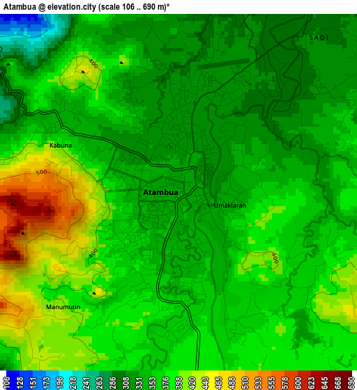
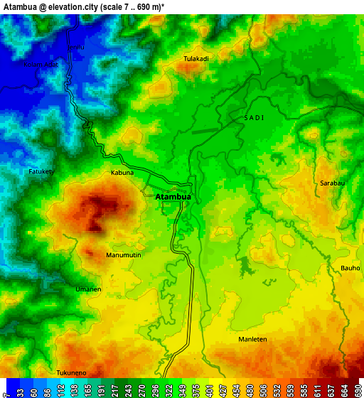
Below is the Elevation map of Atambua, which displays elevation range with different colors. Scale of the first map is from 106 to 690 m (348 to 2264 ft) with average elevation of 366 meters (=1201 ft) [note 1]
These maps also provides idea of topography and contour of this city, they are displayed at different zoom levels. More info about maps, scale and edge coordinates you can find below images.
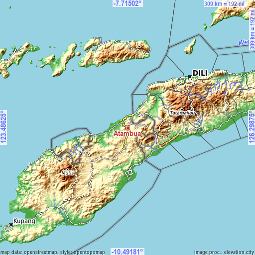
| \ | Map #1 | Map #2 | Topo.Map |
| Scale [m] | 106..690 m | 7..690 m | × |
| Scale [ft] | 348..2264 ft | 23..2264 ft | × |
| Average | 366 m = 1201 ft | 335.5 m = 1101 ft | × |
| Width | 9.65 km = 6 mi | 19.3 km = 12 mi | 308.8 km = 191.9 mi |
| Height | 9.65 km = 6 mi | 19.3 km = 12 mi | 308.8 km = 191.9 mi |
| ↑Max Latitude | -9.062716° | -9.019317° | -7.71502° |
| Latitude at center | -9.10611° | -9.10611° | -9.10611° |
| ↓Min Latitude | -9.149499° | -9.192882° | -10.49181° |
| ← Min Longitude | 124.848555° | 124.804609° | 123.48625° |
| Longitude center | 124.8925° | 124.8925° | 124.8925° |
| →Max Longitude | 124.936445° | 124.980391° | 126.29875° |
Nearby cities:
Cities around Atambua sort by population:
• Kefamenanu elevation 409 m
59.2 km,  230°
230°
• Nikiniki 748 m
90.9 km,  210°
210°
• Kie 790 m
90.4 km,  204°
204°
• Oinlasi 905 m
89.8 km, 202°
• Eban 1053 m
79.8 km, 231°
• Polen 351 m
78.8 km, 214°
• Oeekam 478 m
74.8 km, 206°
• Ayotupas 498 m
68.8 km, 197°
• Noemuti 334 m
67.4 km,  220°
220°
• Sasi 381 m
61.9 km, 225°
• Biudukfoho 551 m
58.1 km, 196°
• Betun 21 m
51.3 km,  178°
178°
Multilingual:
 En español:
Atambua elevación 336 m.
 En France:
Atambua élévation 336 m.


Sources and notes:
- [note 1] Map square and city borders are not equal. Map elevation data is calculated only from area inside that square.
- [src 1] Elevation data from geonames database provided with same terms of usage.
- [src 2] The elevation map of Atambua is generated using elevation data from NASA's 3 arcsec (90m) resolution SRTM data.
- [src 3] Base (background) map © OpenStreetMap contributors tiles are generated by Geofabrik and OpenTopoMap.
Copyright & License:
This Atambua Elevation Map is licensed under CC BY-SA. You may reuse any part from this page, if you give a proper credit by linking to this URL:
 More info on terms of use page.