Seririt elevation
Seririt (Bali), Indonesia elevation is 17 meters and Seririt elevation in feet is 56 ft above sea level [src 1]. Seririt is a seat of a third-order administrative division (feature code) with elevation that is 174 meters (571 ft) smaller than average city elevation in Indonesia.
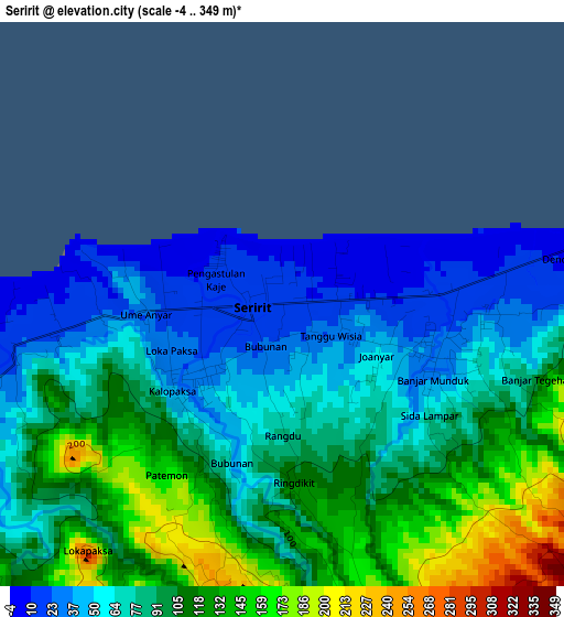
Below is the Elevation map of Seririt, which displays elevation range with different colors. Scale of the first map is from -4 to 349 m (-13 to 1145 ft) with average elevation of 87 meters (=285 ft) [note 1]
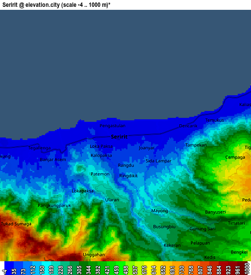
These maps also provides idea of topography and contour of this city, they are displayed at different zoom levels. More info about maps, scale and edge coordinates you can find below images.
| \ | Map #1 | Map #2 | Topo.Map |
| Scale [m] | -4..349 m | -4..1000 m | × |
| Scale [ft] | -13..1145 ft | -13..3281 ft | × |
| Average | 87 m = 285 ft | 276.3 m = 906 ft | × |
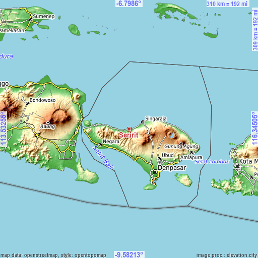
| Width | 9.67 km = 6 mi | 19.35 km = 12 mi | 309.5 km = 192.3 mi |
| Height | 9.67 km = 6 mi | 19.35 km = 12 mi | 309.5 km = 192.3 mi |
| ↑Max Latitude | -8.149301° | -8.105797° | -6.7986° |
| Latitude at center | -8.1928° | -8.1928° | -8.1928° |
| ↓Min Latitude | -8.236294° | -8.279784° | -9.58213° |
| ← Min Longitude | 114.894855° | 114.850909° | 113.53255° |
| Longitude center | 114.9388° | 114.9388° | 114.9388° |
| →Max Longitude | 114.982745° | 115.026691° | 116.34505° |
Nearby cities:
Cities around Seririt sort by population:
• Singaraja elevation 11 m
18.7 km,  61°
61°
• Banjar 15 m
3.2 km,  84°
84°
• Negara 12 m
39.8 km,  242°
242°
• Lovina 5 m
12.1 km,  66°
66°
• Munduk 1163 m
17.6 km,  118°
118°
• Basa 275 m
40.2 km,  141°
141°
• Banjar Mandung 137 m
39.9 km,  155°
155°
• Pohgending Kawan 362 m
35.1 km, 140°
• Baturiti 894 m
30.9 km, 118°
• Pekutatan 37 m
28.4 km,  206°
206°
• Sukasada 110 m
19 km, 71°
• Busungbiu 270 m
7.7 km, 156°
Multilingual:
 En español:
Seririt elevación 17 m.
 En France:
Seririt élévation 17 m.


Sources and notes:
- [note 1] Map square and city borders are not equal. Map elevation data is calculated only from area inside that square.
- [src 1] Elevation data from geonames database provided with same terms of usage.
- [src 2] The elevation map of Seririt is generated using elevation data from NASA's 3 arcsec (90m) resolution SRTM data.
- [src 3] Base (background) map © OpenStreetMap contributors tiles are generated by Geofabrik and OpenTopoMap.
Copyright & License:
This Seririt Elevation Map is licensed under CC BY-SA. You may reuse any part from this page, if you give a proper credit by linking to this URL:
 More info on terms of use page.