Edelény elevation
Edelény (Borsod-Abaúj-Zemplén), Hungary elevation is 131 meters and Edelény elevation in feet is 430 ft above sea level [src 1]. Edelény is a seat of a second-order administrative division (feature code) with elevation that is 2 meters (7 ft) bigger than average city elevation in Hungary.
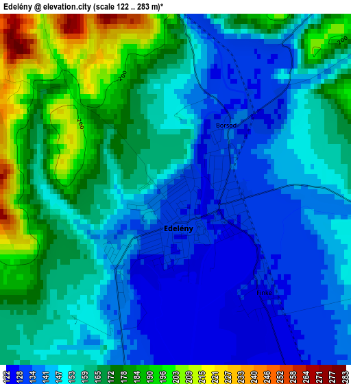
Below is the Elevation map of Edelény, which displays elevation range with different colors. Scale of the first map is from 122 to 283 m (400 to 928 ft) with average elevation of 157.4 meters (=516 ft) [note 1]
These maps also provides idea of topography and contour of this city, they are displayed at different zoom levels. More info about maps, scale and edge coordinates you can find below images.
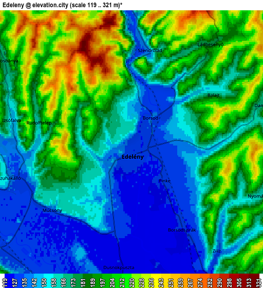
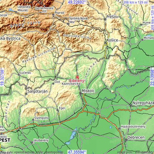
| \ | Map #1 | Map #2 | Topo.Map |
| Scale [m] | 122..283 m | 119..321 m | × |
| Scale [ft] | 400..928 ft | 390..1053 ft | × |
| Average | 157.4 m = 516 ft | 176.8 m = 580 ft | × |
| Width | 6.5 km = 4 mi | 13 km = 8.1 mi | 208 km = 129.2 mi |
| Height | 6.5 km = 4 mi | 13 km = 8.1 mi | 208 km = 129.2 mi |
| ↑Max Latitude | 48.329225° | 48.358434° | 49.22692° |
| Latitude at center | 48.3° | 48.3° | 48.3° |
| ↓Min Latitude | 48.270758° | 48.241499° | 47.35594° |
| ← Min Longitude | 20.689385° | 20.645439° | 19.32708° |
| Longitude center | 20.73333° | 20.73333° | 20.73333° |
| →Max Longitude | 20.777275° | 20.821221° | 22.13958° |
Nearby cities:
Cities around Edelény sort by population:
• Kazincbarcika elevation 185 m
9.3 km,  233°
233°
• Sajószentpéter 125 m
9.3 km,  187°
187°
• Szikszó 115 m
18.5 km,  126°
126°
• Szirmabesenyő 114 m
17.4 km,  163°
163°
• Szendrő 139 m
11.1 km,  0°
0°
• Sajókaza 139 m
11.3 km,  260°
260°
• Múcsony 127 m
5.2 km,  224°
224°
• Sajóbábony 162 m
14.8 km,  180°
180°
• Rudabánya 289 m
11.9 km,  321°
321°
• Boldva 120 m
10.5 km,  151°
151°
• Sajóvámos 122 m
15 km, 151°
• Izsófalva 187 m
4.9 km,  270°
270°
Multilingual:
 En español:
Edelény elevación 131 m.
 En France:
Edelény élévation 131 m.


Sources and notes:
- [note 1] Map square and city borders are not equal. Map elevation data is calculated only from area inside that square.
- [src 1] Elevation data from geonames database provided with same terms of usage.
- [src 2] The elevation map of Edelény is generated using elevation data from NASA's 3 arcsec (90m) resolution SRTM data.
- [src 3] Base (background) map © OpenStreetMap contributors tiles are generated by Geofabrik and OpenTopoMap.
Copyright & License:
This Edelény Elevation Map is licensed under CC BY-SA. You may reuse any part from this page, if you give a proper credit by linking to this URL:
 More info on terms of use page.