Szendrő elevation
Szendrő (Borsod-Abaúj-Zemplén), Hungary elevation is 139 meters and Szendrő elevation in feet is 456 ft above sea level [src 1]. Szendrő is a populated place (feature code) with elevation that is 10 meters (33 ft) bigger than average city elevation in Hungary.
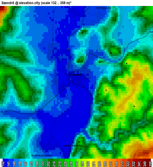
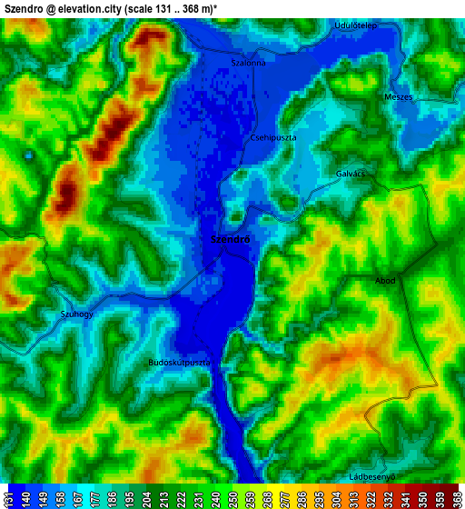
Below is the Elevation map of Szendrő, which displays elevation range with different colors. Scale of the first map is from 132 to 358 m (433 to 1175 ft) with average elevation of 182.6 meters (=599 ft) [note 1]
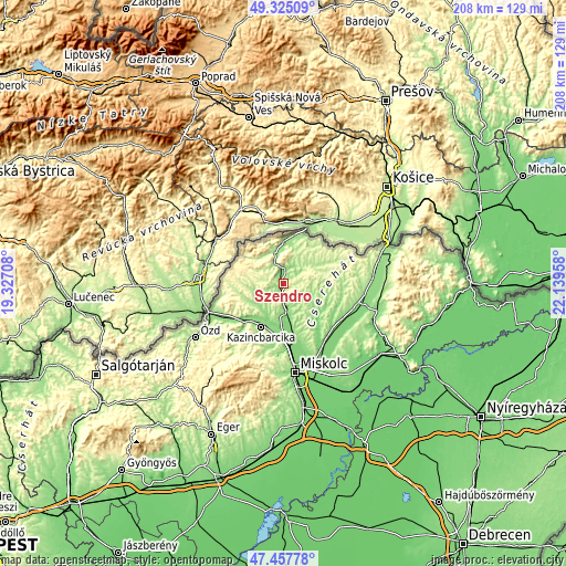
These maps also provides idea of topography and contour of this city, they are displayed at different zoom levels. More info about maps, scale and edge coordinates you can find below images.
| \ | Map #1 | Map #2 | Topo.Map |
| Scale [m] | 132..358 m | 131..368 m | × |
| Scale [ft] | 433..1175 ft | 430..1207 ft | × |
| Average | 182.6 m = 599 ft | 212.2 m = 696 ft | × |
| Width | 6.49 km = 4 mi | 12.98 km = 8.1 mi | 207.6 km = 129 mi |
| Height | 6.49 km = 4 mi | 12.98 km = 8.1 mi | 207.6 km = 129 mi |
| ↑Max Latitude | 48.429168° | 48.458319° | 49.32509° |
| Latitude at center | 48.4° | 48.4° | 48.4° |
| ↓Min Latitude | 48.370815° | 48.341614° | 47.45778° |
| ← Min Longitude | 20.689385° | 20.645439° | 19.32708° |
| Longitude center | 20.73333° | 20.73333° | 20.73333° |
| →Max Longitude | 20.777275° | 20.821221° | 22.13958° |
Nearby cities:
Cities around Szendrő sort by population:
• Kazincbarcika elevation 185 m
18.2 km,  203°
203°
• Sajószentpéter 125 m
20.4 km,  183°
183°
• Edelény 131 m
11.1 km, 180°
• Putnok 178 m
24.8 km,  243°
243°
• Sajókaza 139 m
17.1 km,  220°
220°
• Múcsony 127 m
15.3 km,  193°
193°
• Sajóbábony 162 m
25.9 km, 180°
• Rudabánya 289 m
7.6 km,  255°
255°
• Boldva 120 m
21 km,  166°
166°
• Sajóvámos 122 m
25.3 km,  163°
163°
• Izsófalva 187 m
12.2 km, 203°
• Halmaj 118 m
25.8 km,  130°
130°
Multilingual:
 En español:
Szendrő elevación 139 m.
 En France:
Szendrő élévation 139 m.


Sources and notes:
- [note 1] Map square and city borders are not equal. Map elevation data is calculated only from area inside that square.
- [src 1] Elevation data from geonames database provided with same terms of usage.
- [src 2] The elevation map of Szendrő is generated using elevation data from NASA's 3 arcsec (90m) resolution SRTM data.
- [src 3] Base (background) map © OpenStreetMap contributors tiles are generated by Geofabrik and OpenTopoMap.
Copyright & License:
This Szendrő Elevation Map is licensed under CC BY-SA. You may reuse any part from this page, if you give a proper credit by linking to this URL:
 More info on terms of use page.