Mályi elevation
Mályi (Borsod-Abaúj-Zemplén), Hungary elevation is 104 meters and Mályi elevation in feet is 341 ft above sea level [src 1]. Mályi is a populated place (feature code) with elevation that is 25 meters (82 ft) smaller than average city elevation in Hungary.
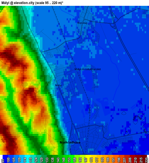
Below is the Elevation map of Mályi, which displays elevation range with different colors. Scale of the first map is from 95 to 220 m (312 to 722 ft) with average elevation of 124 meters (=407 ft) [note 1]
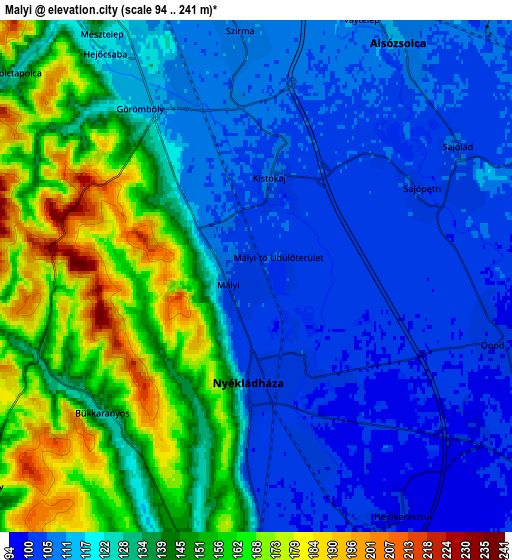
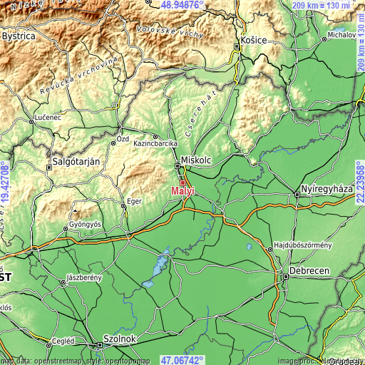
These maps also provides idea of topography and contour of this city, they are displayed at different zoom levels. More info about maps, scale and edge coordinates you can find below images.
| \ | Map #1 | Map #2 | Topo.Map |
| Scale [m] | 95..220 m | 94..241 m | × |
| Scale [ft] | 312..722 ft | 308..791 ft | × |
| Average | 124 m = 407 ft | 128.7 m = 422 ft | × |
| Width | 6.54 km = 4.1 mi | 13.07 km = 8.1 mi | 209.2 km = 130 mi |
| Height | 6.54 km = 4.1 mi | 13.07 km = 8.1 mi | 209.2 km = 130 mi |
| ↑Max Latitude | 48.046057° | 48.075428° | 48.94876° |
| Latitude at center | 48.01667° | 48.01667° | 48.01667° |
| ↓Min Latitude | 47.987266° | 47.957845° | 47.06742° |
| ← Min Longitude | 20.789385° | 20.745439° | 19.42708° |
| Longitude center | 20.83333° | 20.83333° | 20.83333° |
| →Max Longitude | 20.877275° | 20.921221° | 22.23958° |
Nearby cities:
Cities around Mályi sort by population:
• Miskolc elevation 131 m
10 km,  338°
338°
• Felsőzsolca 112 m
9.6 km,  14°
14°
• Alsózsolca 113 m
6.9 km,  30°
30°
• Emőd 108 m
9.3 km,  187°
187°
• Nyékládháza 103 m
3.7 km,  180°
180°
• Onga 113 m
12.7 km, 29°
• Hernádnémeti 111 m
12.5 km,  63°
63°
• Sajólád 104 m
6.2 km,  53°
53°
• Bőcs 102 m
10.6 km,  69°
69°
• Arnót 112 m
12.8 km, 8°
• Ónod 102 m
6.5 km,  106°
106°
• Harsány 158 m
8.3 km,  228°
228°
Multilingual:
 En español:
Mályi elevación 104 m.
 En France:
Mályi élévation 104 m.


Sources and notes:
- [note 1] Map square and city borders are not equal. Map elevation data is calculated only from area inside that square.
- [src 1] Elevation data from geonames database provided with same terms of usage.
- [src 2] The elevation map of Mályi is generated using elevation data from NASA's 3 arcsec (90m) resolution SRTM data.
- [src 3] Base (background) map © OpenStreetMap contributors tiles are generated by Geofabrik and OpenTopoMap.
Copyright & License:
This Mályi Elevation Map is licensed under CC BY-SA. You may reuse any part from this page, if you give a proper credit by linking to this URL:
 More info on terms of use page.