Téglás elevation
Téglás (Hajdú-Bihar), Hungary elevation is 135 meters and Téglás elevation in feet is 443 ft above sea level [src 1]. Téglás is a populated place (feature code) with elevation that is 6 meters (20 ft) bigger than average city elevation in Hungary.
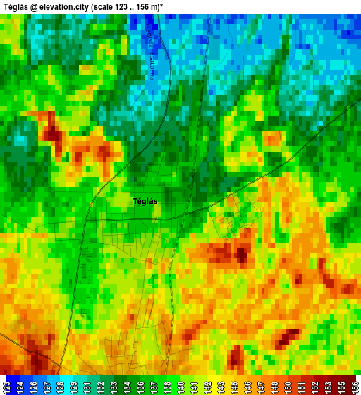
Below is the Elevation map of Téglás, which displays elevation range with different colors. Scale of the first map is from 123 to 156 m (404 to 512 ft) with average elevation of 138.5 meters (=454 ft) [note 1]
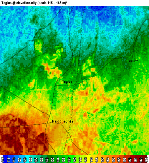
These maps also provides idea of topography and contour of this city, they are displayed at different zoom levels. More info about maps, scale and edge coordinates you can find below images.
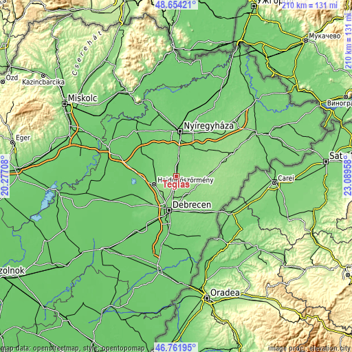
| \ | Map #1 | Map #2 | Topo.Map |
| Scale [m] | 123..156 m | 115..165 m | × |
| Scale [ft] | 404..512 ft | 377..541 ft | × |
| Average | 138.5 m = 454 ft | 136.7 m = 448 ft | × |
| Width | 6.57 km = 4.1 mi | 13.15 km = 8.2 mi | 210.4 km = 130.7 mi |
| Height | 6.57 km = 4.1 mi | 13.15 km = 8.2 mi | 210.4 km = 130.7 mi |
| ↑Max Latitude | 47.746228° | 47.775769° | 48.65421° |
| Latitude at center | 47.71667° | 47.71667° | 47.71667° |
| ↓Min Latitude | 47.687095° | 47.657504° | 46.76195° |
| ← Min Longitude | 21.639385° | 21.595439° | 20.27708° |
| Longitude center | 21.68333° | 21.68333° | 21.68333° |
| →Max Longitude | 21.727275° | 21.771221° | 23.08958° |
Nearby cities:
Cities around Téglás sort by population:
• Debrecen elevation 123 m
20.7 km,  190°
190°
• Hajdúböszörmény 128 m
13.7 km,  245°
245°
• Újfehértó 121 m
9.3 km,  0°
0°
• Hajdúhadház 148 m
3.9 km,  198°
198°
• Hajdúsámson 133 m
14.4 km,  154°
154°
• Nagykálló 123 m
21.2 km,  33°
33°
• Hajdúdorog 109 m
17.6 km,  309°
309°
• Nyíradony 152 m
17.7 km,  96°
96°
• Balkány 138 m
14.7 km,  65°
65°
• Bököny 134 m
5.3 km, 69°
• Szakoly 144 m
18.3 km, 72°
• Kálmánháza 115 m
20 km,  338°
338°
Multilingual:
 En español:
Téglás elevación 135 m.
 En France:
Téglás élévation 135 m.


Sources and notes:
- [note 1] Map square and city borders are not equal. Map elevation data is calculated only from area inside that square.
- [src 1] Elevation data from geonames database provided with same terms of usage.
- [src 2] The elevation map of Téglás is generated using elevation data from NASA's 3 arcsec (90m) resolution SRTM data.
- [src 3] Base (background) map © OpenStreetMap contributors tiles are generated by Geofabrik and OpenTopoMap.
Copyright & License:
This Téglás Elevation Map is licensed under CC BY-SA. You may reuse any part from this page, if you give a proper credit by linking to this URL:
 More info on terms of use page.