Tiszacsege elevation
Tiszacsege (Hajdú-Bihar), Hungary elevation is 89 meters and Tiszacsege elevation in feet is 292 ft above sea level [src 1]. Tiszacsege is a populated place (feature code) with elevation that is 40 meters (131 ft) smaller than average city elevation in Hungary.
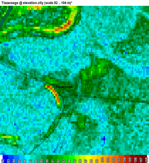
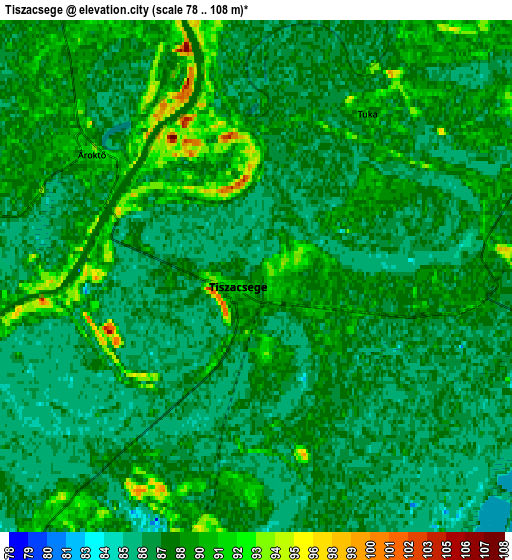
Below is the Elevation map of Tiszacsege, which displays elevation range with different colors. Scale of the first map is from 82 to 104 m (269 to 341 ft) with average elevation of 88 meters (=289 ft) [note 1]
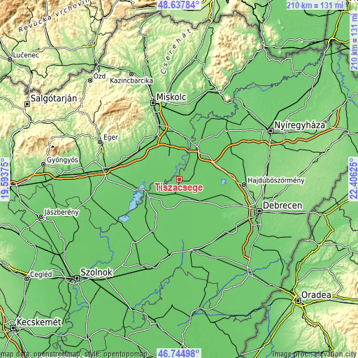
These maps also provides idea of topography and contour of this city, they are displayed at different zoom levels. More info about maps, scale and edge coordinates you can find below images.
| \ | Map #1 | Map #2 | Topo.Map |
| Scale [m] | 82..104 m | 78..108 m | × |
| Scale [ft] | 269..341 ft | 256..354 ft | × |
| Average | 88 m = 289 ft | 88 m = 289 ft | × |
| Width | 6.58 km = 4.1 mi | 13.15 km = 8.2 mi | 210.5 km = 130.8 mi |
| Height | 6.58 km = 4.1 mi | 13.15 km = 8.2 mi | 210.5 km = 130.8 mi |
| ↑Max Latitude | 47.729567° | 47.759118° | 48.63784° |
| Latitude at center | 47.7° | 47.7° | 47.7° |
| ↓Min Latitude | 47.670416° | 47.640815° | 46.74498° |
| ← Min Longitude | 20.956055° | 20.912109° | 19.59375° |
| Longitude center | 21° | 21° | 21° |
| →Max Longitude | 21.043945° | 21.087891° | 22.40625° |
Nearby cities:
Cities around Tiszacsege sort by population:
• Tiszaújváros elevation 89 m
26.7 km,  13°
13°
• Tiszafüred 86 m
19.8 km,  242°
242°
• Polgár 91 m
20.5 km,  25°
25°
• Mezőcsát 91 m
14.4 km,  334°
334°
• Egyek 86 m
10.5 km,  225°
225°
• Poroszló 91 m
25.6 km,  257°
257°
• Tiszakeszi 92 m
9.3 km,  0°
0°
• Szentistván 96 m
26 km,  286°
286°
• Görbeháza 89 m
22.9 km,  49°
49°
• Hejőbába 93 m
22.5 km,  350°
350°
• Tiszaszőlős 88 m
26.4 km, 232°
• Hortobágy 88 m
17.3 km,  139°
139°
Multilingual:
 En español:
Tiszacsege elevación 89 m.
 En France:
Tiszacsege élévation 89 m.
 Auf Deutsch:
Tiszacsege höhe über dem Meeresspiegel ist 89 m.

Sources and notes:
- [note 1] Map square and city borders are not equal. Map elevation data is calculated only from area inside that square.
- [src 1] Elevation data from geonames database provided with same terms of usage.
- [src 2] The elevation map of Tiszacsege is generated using elevation data from NASA's 3 arcsec (90m) resolution SRTM data.
- [src 3] Base (background) map © OpenStreetMap contributors tiles are generated by Geofabrik and OpenTopoMap.
Copyright & License:
This Tiszacsege Elevation Map is licensed under CC BY-SA. You may reuse any part from this page, if you give a proper credit by linking to this URL:
 More info on terms of use page.