Tiszafüred elevation
Tiszafüred (Jász-Nagykun-Szolnok), Hungary elevation is 86 meters and Tiszafüred elevation in feet is 282 ft above sea level [src 1]. Tiszafüred is a seat of a second-order administrative division (feature code) with elevation that is 43 meters (141 ft) smaller than average city elevation in Hungary.
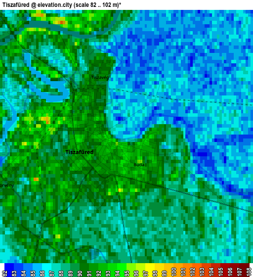
Below is the Elevation map of Tiszafüred, which displays elevation range with different colors. Scale of the first map is from 82 to 102 m (269 to 335 ft) with average elevation of 87.9 meters (=288 ft) [note 1]
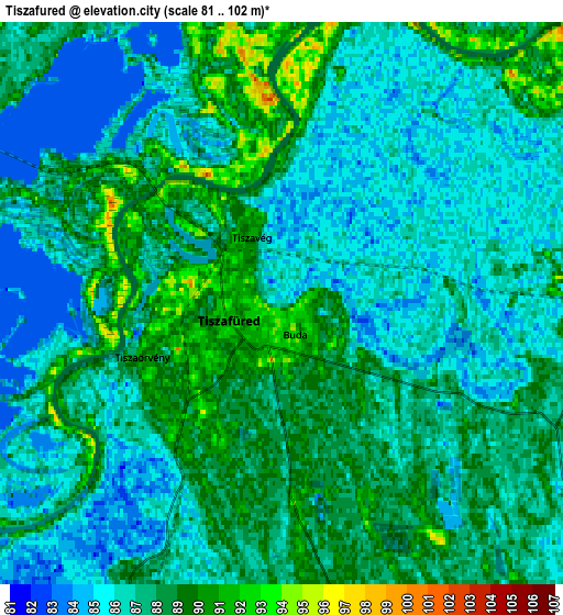
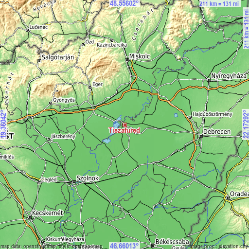
These maps also provides idea of topography and contour of this city, they are displayed at different zoom levels. More info about maps, scale and edge coordinates you can find below images.
| \ | Map #1 | Map #2 | Topo.Map |
| Scale [m] | 82..102 m | 81..102 m | × |
| Scale [ft] | 269..335 ft | 266..335 ft | × |
| Average | 87.9 m = 288 ft | 87 m = 285 ft | × |
| Width | 6.59 km = 4.1 mi | 13.18 km = 8.2 mi | 210.8 km = 131 mi |
| Height | 6.59 km = 4.1 mi | 13.18 km = 8.2 mi | 210.8 km = 131 mi |
| ↑Max Latitude | 47.646285° | 47.675882° | 48.55602° |
| Latitude at center | 47.61667° | 47.61667° | 47.61667° |
| ↓Min Latitude | 47.587039° | 47.55739° | 46.66013° |
| ← Min Longitude | 20.722725° | 20.678779° | 19.36042° |
| Longitude center | 20.76667° | 20.76667° | 20.76667° |
| →Max Longitude | 20.810615° | 20.854561° | 22.17292° |
Nearby cities:
Cities around Tiszafüred sort by population:
• Mezőcsát elevation 91 m
24.9 km,  26°
26°
• Kunmadaras 90 m
20.5 km,  173°
173°
• Egyek 86 m
10.2 km,  79°
79°
• Tiszacsege 89 m
19.8 km,  62°
62°
• Abádszalók 87 m
20.8 km,  216°
216°
• Mezőkeresztes 104 m
24.6 km,  348°
348°
• Kisköre 85 m
23.8 km,  237°
237°
• Poroszló 91 m
8.4 km,  296°
296°
• Szentistván 96 m
18.3 km,  335°
335°
• Tiszanána 84 m
18.4 km,  252°
252°
• Tiszaszentimre 88 m
15 km,  189°
189°
• Tiszaszőlős 88 m
7.5 km,  208°
208°
Multilingual:
 En español:
Tiszafüred elevación 86 m.
 En France:
Tiszafüred élévation 86 m.
 Auf Deutsch:
Tiszafüred höhe über dem Meeresspiegel ist 86 m.

Sources and notes:
- [note 1] Map square and city borders are not equal. Map elevation data is calculated only from area inside that square.
- [src 1] Elevation data from geonames database provided with same terms of usage.
- [src 2] The elevation map of Tiszafüred is generated using elevation data from NASA's 3 arcsec (90m) resolution SRTM data.
- [src 3] Base (background) map © OpenStreetMap contributors tiles are generated by Geofabrik and OpenTopoMap.
Copyright & License:
This Tiszafüred Elevation Map is licensed under CC BY-SA. You may reuse any part from this page, if you give a proper credit by linking to this URL:
 More info on terms of use page.