Verpelét elevation
Verpelét (Heves), Hungary elevation is 150 meters and Verpelét elevation in feet is 492 ft above sea level [src 1]. Verpelét is a populated place (feature code) with elevation that is 21 meters (69 ft) bigger than average city elevation in Hungary.
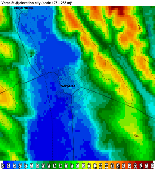
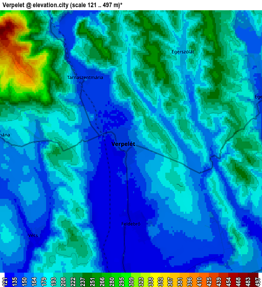
Below is the Elevation map of Verpelét, which displays elevation range with different colors. Scale of the first map is from 127 to 258 m (417 to 846 ft) with average elevation of 166.9 meters (=548 ft) [note 1]
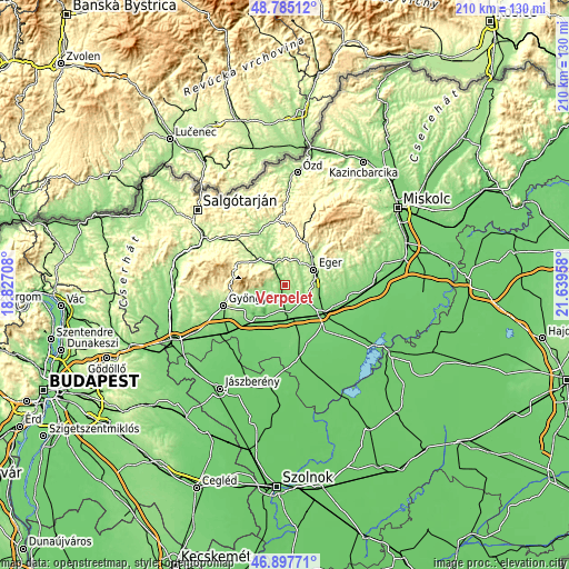
These maps also provides idea of topography and contour of this city, they are displayed at different zoom levels. More info about maps, scale and edge coordinates you can find below images.
| \ | Map #1 | Map #2 | Topo.Map |
| Scale [m] | 127..258 m | 121..497 m | × |
| Scale [ft] | 417..846 ft | 397..1631 ft | × |
| Average | 166.9 m = 548 ft | 185.2 m = 608 ft | × |
| Width | 6.56 km = 4.1 mi | 13.12 km = 8.2 mi | 209.9 km = 130.4 mi |
| Height | 6.56 km = 4.1 mi | 13.12 km = 8.2 mi | 209.8 km = 130.4 mi |
| ↑Max Latitude | 47.879482° | 47.908948° | 48.78512° |
| Latitude at center | 47.85° | 47.85° | 47.85° |
| ↓Min Latitude | 47.820501° | 47.790985° | 46.89771° |
| ← Min Longitude | 20.189385° | 20.145439° | 18.82708° |
| Longitude center | 20.23333° | 20.23333° | 20.23333° |
| →Max Longitude | 20.277275° | 20.321221° | 21.63958° |
Nearby cities:
Cities around Verpelét sort by population:
• Eger elevation 168 m
12 km,  60°
60°
• Kál 116 m
13.2 km,  169°
169°
• Recsk 171 m
12.7 km,  316°
316°
• Andornaktálya 172 m
13.7 km,  90°
90°
• Ostoros 158 m
15 km,  82°
82°
• Maklár 120 m
14.8 km,  112°
112°
• Mátraderecske 214 m
15.8 km,  314°
314°
• Kerecsend 142 m
10.3 km,  122°
122°
• Kompolt 114 m
13 km, 174°
• Domoszló 192 m
8.9 km,  257°
257°
• Sirok 173 m
9.6 km,  344°
344°
• Egerszalók 193 m
7.7 km, 76°
Multilingual:
 En español:
Verpelét elevación 150 m.
 En France:
Verpelét élévation 150 m.
 Auf Deutsch:
Verpelét höhe über dem Meeresspiegel ist 150 m.

Sources and notes:
- [note 1] Map square and city borders are not equal. Map elevation data is calculated only from area inside that square.
- [src 1] Elevation data from geonames database provided with same terms of usage.
- [src 2] The elevation map of Verpelét is generated using elevation data from NASA's 3 arcsec (90m) resolution SRTM data.
- [src 3] Base (background) map © OpenStreetMap contributors tiles are generated by Geofabrik and OpenTopoMap.
Copyright & License:
This Verpelét Elevation Map is licensed under CC BY-SA. You may reuse any part from this page, if you give a proper credit by linking to this URL:
 More info on terms of use page.