Jánoshalma elevation
Jánoshalma (Bács-Kiskun), Hungary elevation is 136 meters and Jánoshalma elevation in feet is 446 ft above sea level [src 1]. Jánoshalma is a seat of a second-order administrative division (feature code) with elevation that is 7 meters (23 ft) bigger than average city elevation in Hungary.
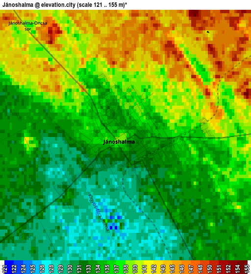
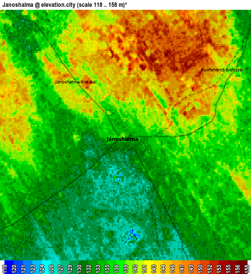
Below is the Elevation map of Jánoshalma, which displays elevation range with different colors. Scale of the first map is from 121 to 155 m (397 to 509 ft) with average elevation of 136.4 meters (=448 ft) [note 1]
These maps also provides idea of topography and contour of this city, they are displayed at different zoom levels. More info about maps, scale and edge coordinates you can find below images.
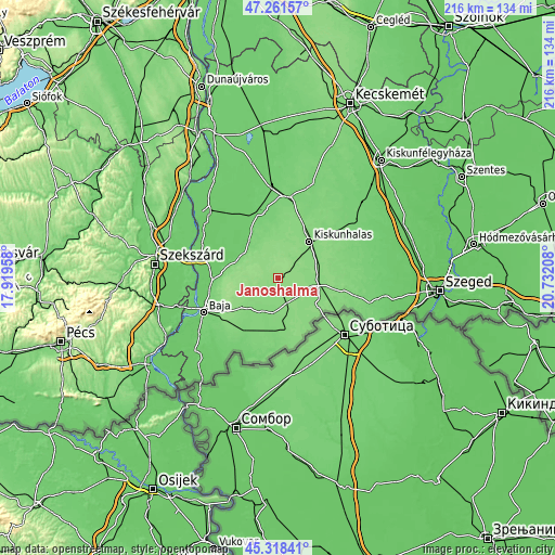
| \ | Map #1 | Map #2 | Topo.Map |
| Scale [m] | 121..155 m | 118..158 m | × |
| Scale [ft] | 397..509 ft | 387..518 ft | × |
| Average | 136.4 m = 448 ft | 137 m = 449 ft | × |
| Width | 6.75 km = 4.2 mi | 13.5 km = 8.4 mi | 216.1 km = 134.3 mi |
| Height | 6.75 km = 4.2 mi | 13.5 km = 8.4 mi | 216 km = 134.2 mi |
| ↑Max Latitude | 46.328963° | 46.3593° | 47.26157° |
| Latitude at center | 46.29861° | 46.29861° | 46.29861° |
| ↓Min Latitude | 46.26824° | 46.237853° | 45.31841° |
| ← Min Longitude | 19.281885° | 19.237939° | 17.91958° |
| Longitude center | 19.32583° | 19.32583° | 19.32583° |
| →Max Longitude | 19.369775° | 19.413721° | 20.73208° |
Nearby cities:
Cities around Jánoshalma sort by population:
• Kiskunhalas elevation 127 m
19.4 km,  39°
39°
• Bácsalmás 123 m
19.1 km,  178°
178°
• Mélykút 133 m
10.2 km,  155°
155°
• Tompa 131 m
19.4 km,  122°
122°
• Hajós 89 m
19.3 km,  305°
305°
• Bácsbokod 115 m
23.3 km,  214°
214°
• Kisszállás 130 m
12.7 km,  99°
99°
• Császártöltés 109 m
17.5 km,  321°
321°
• Kunfehértó 134 m
9.7 km, 44°
• Csávoly 130 m
18.4 km,  228°
228°
• Nemesnádudvar 91 m
21.6 km,  282°
282°
• Felsőszentiván 127 m
15.5 km,  223°
223°
Multilingual:
 En español:
Jánoshalma elevación 136 m.
 En France:
Jánoshalma élévation 136 m.
 Auf Deutsch:
Jánoshalma höhe über dem Meeresspiegel ist 136 m.

Sources and notes:
- [note 1] Map square and city borders are not equal. Map elevation data is calculated only from area inside that square.
- [src 1] Elevation data from geonames database provided with same terms of usage.
- [src 2] The elevation map of Jánoshalma is generated using elevation data from NASA's 3 arcsec (90m) resolution SRTM data.
- [src 3] Base (background) map © OpenStreetMap contributors tiles are generated by Geofabrik and OpenTopoMap.
Copyright & License:
This Jánoshalma Elevation Map is licensed under CC BY-SA. You may reuse any part from this page, if you give a proper credit by linking to this URL:
 More info on terms of use page.