Mélykút elevation
Mélykút (Bács-Kiskun), Hungary elevation is 133 meters and Mélykút elevation in feet is 436 ft above sea level [src 1]. Mélykút is a populated place (feature code) with elevation that is 4 meters (13 ft) bigger than average city elevation in Hungary.
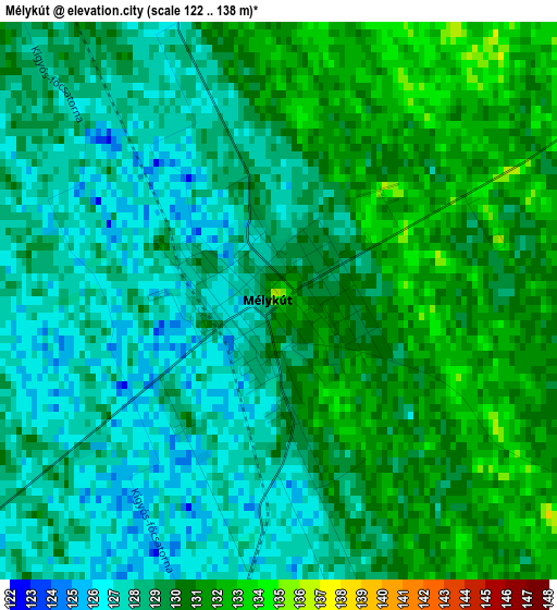
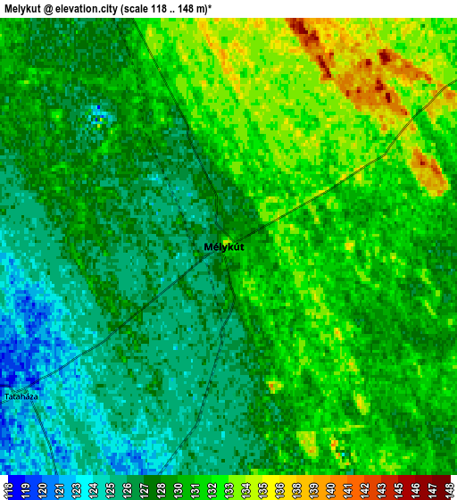
Below is the Elevation map of Mélykút, which displays elevation range with different colors. Scale of the first map is from 122 to 138 m (400 to 453 ft) with average elevation of 128.9 meters (=423 ft) [note 1]
These maps also provides idea of topography and contour of this city, they are displayed at different zoom levels. More info about maps, scale and edge coordinates you can find below images.
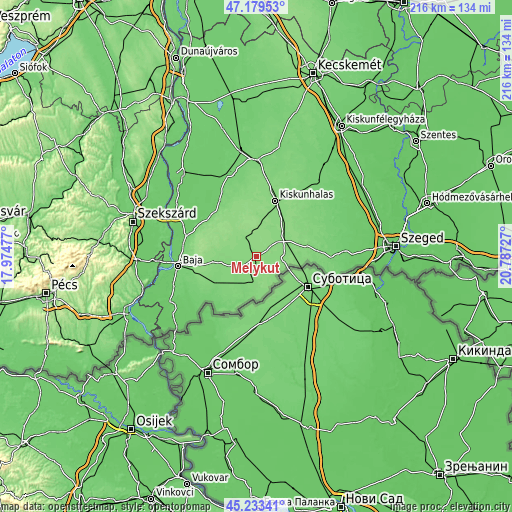
| \ | Map #1 | Map #2 | Topo.Map |
| Scale [m] | 122..138 m | 118..148 m | × |
| Scale [ft] | 400..453 ft | 387..486 ft | × |
| Average | 128.9 m = 423 ft | 129.2 m = 424 ft | × |
| Width | 6.76 km = 4.2 mi | 13.52 km = 8.4 mi | 216.4 km = 134.5 mi |
| Height | 6.76 km = 4.2 mi | 13.52 km = 8.4 mi | 216.4 km = 134.5 mi |
| ↑Max Latitude | 46.24549° | 46.275873° | 47.17953° |
| Latitude at center | 46.21509° | 46.21509° | 46.21509° |
| ↓Min Latitude | 46.184673° | 46.15424° | 45.23341° |
| ← Min Longitude | 19.337075° | 19.293129° | 17.97477° |
| Longitude center | 19.38102° | 19.38102° | 19.38102° |
| →Max Longitude | 19.424965° | 19.468911° | 20.78727° |
Nearby cities:
Cities around Mélykút sort by population:
• Kiskunhalas elevation 127 m
25.6 km,  18°
18°
• Jánoshalma 136 m
10.2 km,  335°
335°
• Bácsalmás 123 m
10.5 km,  200°
200°
• Tompa 131 m
12.2 km,  94°
94°
• Madaras 116 m
19.7 km,  207°
207°
• Bácsbokod 115 m
20 km,  239°
239°
• Kelebia 129 m
18.2 km,  96°
96°
• Kisszállás 130 m
11 km,  49°
49°
• Katymár 103 m
24.1 km, 213°
• Kunfehértó 134 m
16.4 km,  9°
9°
• Csávoly 130 m
18.3 km,  260°
260°
• Felsőszentiván 127 m
15.1 km, 262°
Multilingual:
 En español:
Mélykút elevación 133 m.
 En France:
Mélykút élévation 133 m.


Sources and notes:
- [note 1] Map square and city borders are not equal. Map elevation data is calculated only from area inside that square.
- [src 1] Elevation data from geonames database provided with same terms of usage.
- [src 2] The elevation map of Mélykút is generated using elevation data from NASA's 3 arcsec (90m) resolution SRTM data.
- [src 3] Base (background) map © OpenStreetMap contributors tiles are generated by Geofabrik and OpenTopoMap.
Copyright & License:
This Mélykút Elevation Map is licensed under CC BY-SA. You may reuse any part from this page, if you give a proper credit by linking to this URL:
 More info on terms of use page.