Lenti elevation
Lenti (Zala), Hungary elevation is 168 meters and Lenti elevation in feet is 551 ft above sea level [src 1]. Lenti is a seat of a second-order administrative division (feature code) with elevation that is 39 meters (128 ft) bigger than average city elevation in Hungary.
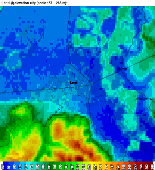
Below is the Elevation map of Lenti, which displays elevation range with different colors. Scale of the first map is from 157 to 266 m (515 to 873 ft) with average elevation of 178.3 meters (=585 ft) [note 1]
These maps also provides idea of topography and contour of this city, they are displayed at different zoom levels. More info about maps, scale and edge coordinates you can find below images.
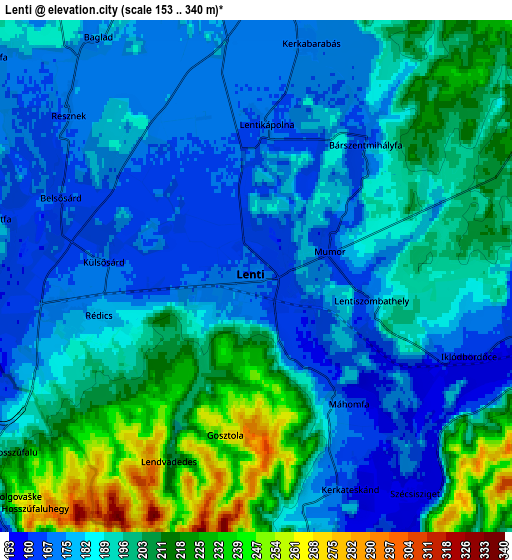
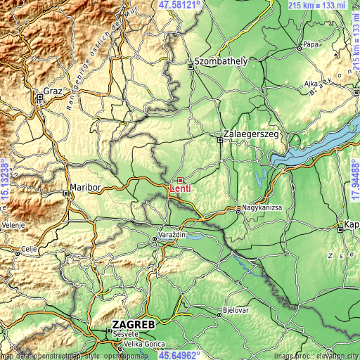
| \ | Map #1 | Map #2 | Topo.Map |
| Scale [m] | 157..266 m | 153..340 m | × |
| Scale [ft] | 515..873 ft | 502..1115 ft | × |
| Average | 178.3 m = 585 ft | 191.3 m = 628 ft | × |
| Width | 6.71 km = 4.2 mi | 13.42 km = 8.3 mi | 214.8 km = 133.5 mi |
| Height | 6.71 km = 4.2 mi | 13.42 km = 8.3 mi | 214.8 km = 133.5 mi |
| ↑Max Latitude | 46.654202° | 46.684358° | 47.58121° |
| Latitude at center | 46.62403° | 46.62403° | 46.62403° |
| ↓Min Latitude | 46.593841° | 46.563635° | 45.64962° |
| ← Min Longitude | 16.494685° | 16.450739° | 15.13238° |
| Longitude center | 16.53863° | 16.53863° | 16.53863° |
| →Max Longitude | 16.582575° | 16.626521° | 17.94488° |
Nearby cities:
Cities around Lenti sort by population:
• Zalaegerszeg elevation 152 m
33.4 km,  44°
44°
• Nagykanizsa 152 m
39.5 km,  118°
118°
• Körmend 192 m
43.3 km,  6°
6°
• Szentgotthárd 229 m
41.7 km,  331°
331°
• Vasvár 202 m
51.3 km,  22°
22°
• Letenye 148 m
25.6 km,  146°
146°
• Zalalövő 199 m
25.2 km, 8°
• Zalakomár 124 m
50 km,  101°
101°
• Becsehely 180 m
26.8 km,  137°
137°
• Murakeresztúr 135 m
39 km, 137°
• Pacsa 175 m
37.8 km,  73°
73°
• Sármellék 123 m
49.1 km,  78°
78°
Multilingual:
 En español:
Lenti elevación 168 m.
 En France:
Lenti élévation 168 m.


Sources and notes:
- [note 1] Map square and city borders are not equal. Map elevation data is calculated only from area inside that square.
- [src 1] Elevation data from geonames database provided with same terms of usage.
- [src 2] The elevation map of Lenti is generated using elevation data from NASA's 3 arcsec (90m) resolution SRTM data.
- [src 3] Base (background) map © OpenStreetMap contributors tiles are generated by Geofabrik and OpenTopoMap.
Copyright & License:
This Lenti Elevation Map is licensed under CC BY-SA. You may reuse any part from this page, if you give a proper credit by linking to this URL:
 More info on terms of use page.