Nagykáta elevation
Nagykáta (Pest), Hungary elevation is 112 meters and Nagykáta elevation in feet is 367 ft above sea level [src 1]. Nagykáta is a seat of a second-order administrative division (feature code) with elevation that is 17 meters (56 ft) smaller than average city elevation in Hungary.
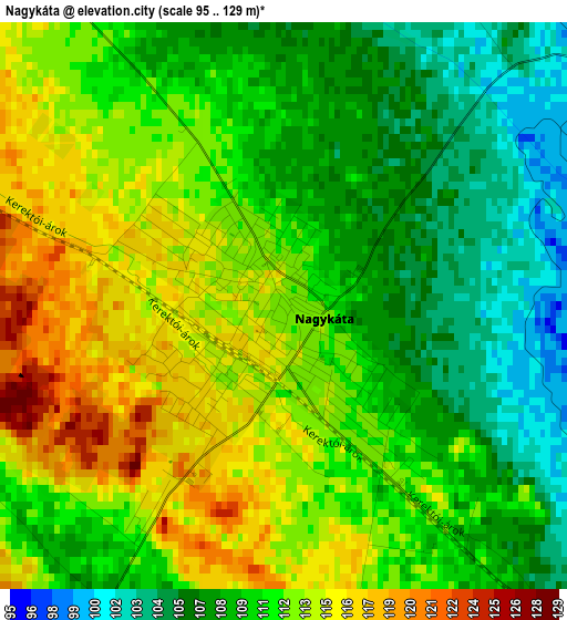
Below is the Elevation map of Nagykáta, which displays elevation range with different colors. Scale of the first map is from 95 to 129 m (312 to 423 ft) with average elevation of 110.8 meters (=364 ft) [note 1]
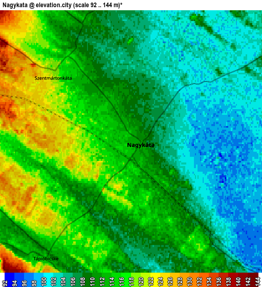
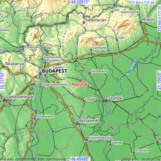
These maps also provides idea of topography and contour of this city, they are displayed at different zoom levels. More info about maps, scale and edge coordinates you can find below images.
| \ | Map #1 | Map #2 | Topo.Map |
| Scale [m] | 95..129 m | 92..144 m | × |
| Scale [ft] | 312..423 ft | 302..472 ft | × |
| Average | 110.8 m = 364 ft | 110.3 m = 362 ft | × |
| Width | 6.61 km = 4.1 mi | 13.23 km = 8.2 mi | 211.6 km = 131.5 mi |
| Height | 6.61 km = 4.1 mi | 13.23 km = 8.2 mi | 211.6 km = 131.5 mi |
| ↑Max Latitude | 47.444869° | 47.47458° | 48.35813° |
| Latitude at center | 47.41514° | 47.41514° | 47.41514° |
| ↓Min Latitude | 47.385395° | 47.355632° | 46.45495° |
| ← Min Longitude | 19.700155° | 19.656209° | 18.33785° |
| Longitude center | 19.7441° | 19.7441° | 19.7441° |
| →Max Longitude | 19.788045° | 19.831991° | 21.15035° |
Nearby cities:
Cities around Nagykáta sort by population:
• Tápiószecső elevation 137 m
10.9 km,  290°
290°
• Tápiószele 98 m
13.3 km,  131°
131°
• Tápiószentmárton 108 m
8.4 km,  178°
178°
• Szentmártonkáta 117 m
5.4 km,  323°
323°
• Kóka 145 m
14.7 km,  302°
302°
• Farmos 99 m
9.8 km, 128°
• Tápióbicske 113 m
7.4 km,  215°
215°
• Tóalmás 126 m
11.8 km,  330°
330°
• Tápióság 133 m
8.7 km,  260°
260°
• Forrópuszta 132 m
7.7 km,  305°
305°
• Pánd 134 m
10.7 km,  229°
229°
• Szentlőrinckáta 106 m
11.6 km,  3°
3°
Multilingual:
 En español:
Nagykáta elevación 112 m.
 En France:
Nagykáta élévation 112 m.
 Auf Deutsch:
Nagykáta höhe über dem Meeresspiegel ist 112 m.

Sources and notes:
- [note 1] Map square and city borders are not equal. Map elevation data is calculated only from area inside that square.
- [src 1] Elevation data from geonames database provided with same terms of usage.
- [src 2] The elevation map of Nagykáta is generated using elevation data from NASA's 3 arcsec (90m) resolution SRTM data.
- [src 3] Base (background) map © OpenStreetMap contributors tiles are generated by Geofabrik and OpenTopoMap.
Copyright & License:
This Nagykáta Elevation Map is licensed under CC BY-SA. You may reuse any part from this page, if you give a proper credit by linking to this URL:
 More info on terms of use page.