Pécs elevation
Pécs (Baranya), Hungary elevation is 193 meters and Pécs elevation in feet is 633 ft above sea level [src 1]. Pécs is a seat of a first-order administrative division (feature code) with elevation that is 64 meters (210 ft) bigger than average city elevation in Hungary.
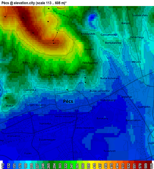
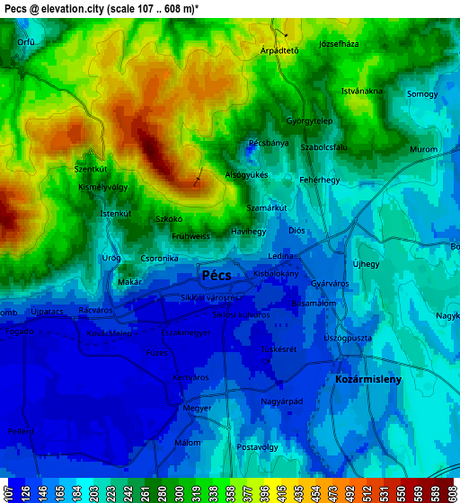
Below is the Elevation map of Pécs, which displays elevation range with different colors. Scale of the first map is from 113 to 608 m (371 to 1995 ft) with average elevation of 220.5 meters (=723 ft) [note 1]
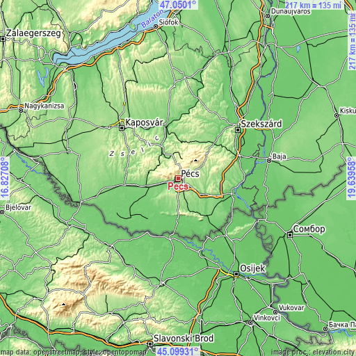
These maps also provides idea of topography and contour of this city, they are displayed at different zoom levels. More info about maps, scale and edge coordinates you can find below images.
| \ | Map #1 | Map #2 | Topo.Map |
| Scale [m] | 113..608 m | 107..608 m | × |
| Scale [ft] | 371..1995 ft | 351..1995 ft | × |
| Average | 220.5 m = 723 ft | 238.4 m = 782 ft | × |
| Width | 6.78 km = 4.2 mi | 13.56 km = 8.4 mi | 216.9 km = 134.8 mi |
| Height | 6.78 km = 4.2 mi | 13.56 km = 8.4 mi | 216.9 km = 134.8 mi |
| ↑Max Latitude | 46.113803° | 46.144258° | 47.0501° |
| Latitude at center | 46.08333° | 46.08333° | 46.08333° |
| ↓Min Latitude | 46.052841° | 46.022334° | 45.09931° |
| ← Min Longitude | 18.189385° | 18.145439° | 16.82708° |
| Longitude center | 18.23333° | 18.23333° | 18.23333° |
| →Max Longitude | 18.277275° | 18.321221° | 19.63958° |
Nearby cities:
Cities around Pécs sort by population:
• Komló elevation 246 m
12.4 km,  11°
11°
• Siklós 104 m
25.9 km,  168°
168°
• Szentlőrinc 119 m
19.6 km,  255°
255°
• Kozármisleny 161 m
7.5 km,  142°
142°
• Pécsvárad 216 m
17 km,  59°
59°
• Bóly 136 m
25.5 km,  120°
120°
• Sásd 134 m
21.4 km,  333°
333°
• Hosszúhetény 273 m
12.8 km,  45°
45°
• Szászvár 162 m
24.1 km,  27°
27°
• Pellérd 119 m
8.2 km,  228°
228°
• Mecseknádasd 181 m
24.1 km, 49°
• Bükkösd 149 m
19.1 km,  278°
278°
Multilingual:
 En español:
Pécs elevación 193 m.
 En France:
Pécs élévation 193 m.
 Auf Deutsch:
Fünfkirchen höhe über dem Meeresspiegel ist 193 m.

Sources and notes:
- [note 1] Map square and city borders are not equal. Map elevation data is calculated only from area inside that square.
- [src 1] Elevation data from geonames database provided with same terms of usage.
- [src 2] The elevation map of Pécs is generated using elevation data from NASA's 3 arcsec (90m) resolution SRTM data.
- [src 3] Base (background) map © OpenStreetMap contributors tiles are generated by Geofabrik and OpenTopoMap.
Copyright & License:
This Pécs Elevation Map is licensed under CC BY-SA. You may reuse any part from this page, if you give a proper credit by linking to this URL:
 More info on terms of use page.