Pétfürdő elevation
Pétfürdő (Veszprém), Hungary elevation is 138 meters and Pétfürdő elevation in feet is 453 ft above sea level [src 1]. Pétfürdő is a populated place (feature code) with elevation that is 9 meters (30 ft) bigger than average city elevation in Hungary.
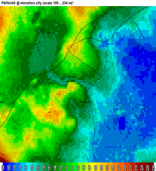
Below is the Elevation map of Pétfürdő, which displays elevation range with different colors. Scale of the first map is from 100 to 234 m (328 to 768 ft) with average elevation of 141.8 meters (=465 ft) [note 1]
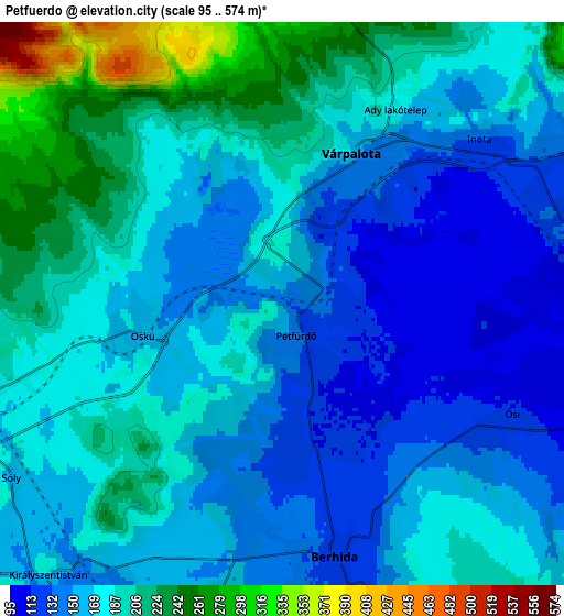
These maps also provides idea of topography and contour of this city, they are displayed at different zoom levels. More info about maps, scale and edge coordinates you can find below images.
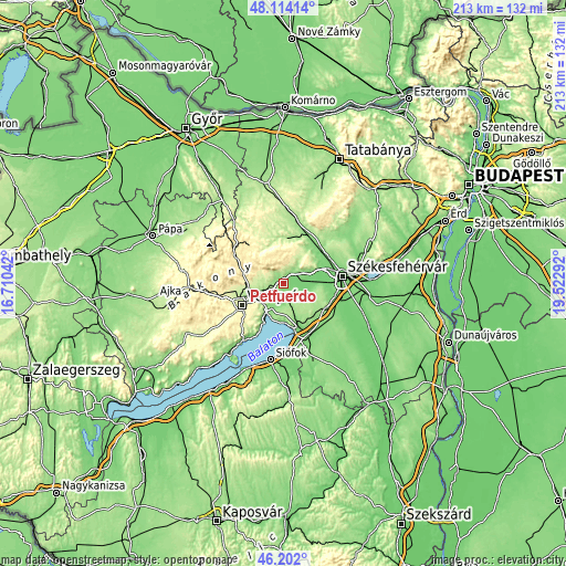
| \ | Map #1 | Map #2 | Topo.Map |
| Scale [m] | 100..234 m | 95..574 m | × |
| Scale [ft] | 328..768 ft | 312..1883 ft | × |
| Average | 141.8 m = 465 ft | 174.7 m = 573 ft | × |
| Width | 6.64 km = 4.1 mi | 13.29 km = 8.3 mi | 212.6 km = 132.1 mi |
| Height | 6.64 km = 4.1 mi | 13.29 km = 8.3 mi | 212.6 km = 132.1 mi |
| ↑Max Latitude | 47.196539° | 47.22639° | 48.11414° |
| Latitude at center | 47.16667° | 47.16667° | 47.16667° |
| ↓Min Latitude | 47.136785° | 47.106882° | 46.202° |
| ← Min Longitude | 18.072725° | 18.028779° | 16.71042° |
| Longitude center | 18.11667° | 18.11667° | 18.11667° |
| →Max Longitude | 18.160615° | 18.204561° | 19.52292° |
Nearby cities:
Cities around Pétfürdő sort by population:
• Veszprém elevation 265 m
17.5 km,  242°
242°
• Várpalota 158 m
4 km,  25°
25°
• Balatonalmádi 109 m
16.3 km,  206°
206°
• Berhida 130 m
6.2 km,  171°
171°
• Balatonkenese 127 m
14.1 km,  183°
183°
• Bakonycsernye 210 m
17.8 km,  349°
349°
• Sárszentmihály 108 m
16.9 km,  95°
95°
• Hajmáskér 167 m
7.7 km,  251°
251°
• Ősi 110 m
5.8 km,  111°
111°
• Szentkirályszabadja 265 m
16.4 km,  222°
222°
• Litér 209 m
11.2 km,  229°
229°
• Kincsesbánya 139 m
16.3 km,  48°
48°
Multilingual:
 En español:
Pétfürdő elevación 138 m.
 En France:
Pétfürdő élévation 138 m.
 Auf Deutsch:
Pétfürdő höhe über dem Meeresspiegel ist 138 m.

Sources and notes:
- [note 1] Map square and city borders are not equal. Map elevation data is calculated only from area inside that square.
- [src 1] Elevation data from geonames database provided with same terms of usage.
- [src 2] The elevation map of Pétfürdő is generated using elevation data from NASA's 3 arcsec (90m) resolution SRTM data.
- [src 3] Base (background) map © OpenStreetMap contributors tiles are generated by Geofabrik and OpenTopoMap.
Copyright & License:
This Pétfürdő Elevation Map is licensed under CC BY-SA. You may reuse any part from this page, if you give a proper credit by linking to this URL:
 More info on terms of use page.