Polgárdi elevation
Polgárdi (Fejér), Hungary elevation is 151 meters and Polgárdi elevation in feet is 495 ft above sea level [src 1]. Polgárdi is a seat of a second-order administrative division (feature code) with elevation that is 22 meters (72 ft) bigger than average city elevation in Hungary.
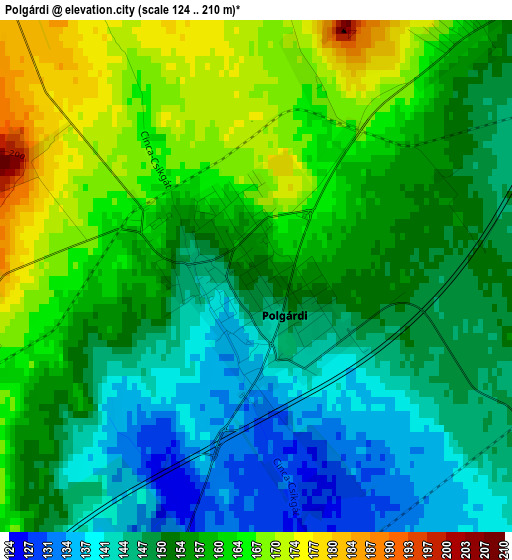
Below is the Elevation map of Polgárdi, which displays elevation range with different colors. Scale of the first map is from 124 to 210 m (407 to 689 ft) with average elevation of 154.4 meters (=507 ft) [note 1]
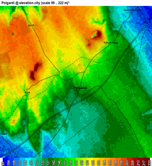
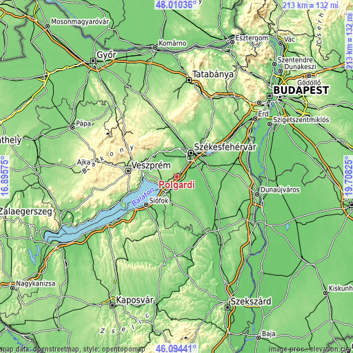
These maps also provides idea of topography and contour of this city, they are displayed at different zoom levels. More info about maps, scale and edge coordinates you can find below images.
| \ | Map #1 | Map #2 | Topo.Map |
| Scale [m] | 124..210 m | 99..222 m | × |
| Scale [ft] | 407..689 ft | 325..728 ft | × |
| Average | 154.4 m = 507 ft | 152.6 m = 501 ft | × |
| Width | 6.66 km = 4.1 mi | 13.31 km = 8.3 mi | 213 km = 132.4 mi |
| Height | 6.66 km = 4.1 mi | 13.31 km = 8.3 mi | 213 km = 132.4 mi |
| ↑Max Latitude | 47.090918° | 47.120829° | 48.01036° |
| Latitude at center | 47.06099° | 47.06099° | 47.06099° |
| ↓Min Latitude | 47.031045° | 47.001084° | 46.09441° |
| ← Min Longitude | 18.258055° | 18.214109° | 16.89575° |
| Longitude center | 18.302° | 18.302° | 18.302° |
| →Max Longitude | 18.345945° | 18.389891° | 19.70825° |
Nearby cities:
Cities around Polgárdi sort by population:
• Székesfehérvár elevation 117 m
16.5 km,  29°
29°
• Enying 127 m
15.2 km,  197°
197°
• Berhida 130 m
14.2 km,  293°
293°
• Szabadbattyán 110 m
8.2 km,  37°
37°
• Aba 109 m
17 km,  102°
102°
• Balatonkenese 127 m
15 km,  261°
261°
• Lepsény 110 m
9 km,  209°
209°
• Sárszentmihály 108 m
10.6 km,  15°
15°
• Kisláng 137 m
13.2 km,  150°
150°
• Káloz 112 m
18.1 km,  130°
130°
• Ősi 110 m
12.9 km,  318°
318°
• Soponya 104 m
12.6 km,  114°
114°
Multilingual:
 En español:
Polgárdi elevación 151 m.
 En France:
Polgárdi élévation 151 m.
 Auf Deutsch:
Polgárdi höhe über dem Meeresspiegel ist 151 m.

Sources and notes:
- [note 1] Map square and city borders are not equal. Map elevation data is calculated only from area inside that square.
- [src 1] Elevation data from geonames database provided with same terms of usage.
- [src 2] The elevation map of Polgárdi is generated using elevation data from NASA's 3 arcsec (90m) resolution SRTM data.
- [src 3] Base (background) map © OpenStreetMap contributors tiles are generated by Geofabrik and OpenTopoMap.
Copyright & License:
This Polgárdi Elevation Map is licensed under CC BY-SA. You may reuse any part from this page, if you give a proper credit by linking to this URL:
 More info on terms of use page.