Solt elevation
Solt (Bács-Kiskun), Hungary elevation is 87 meters and Solt elevation in feet is 285 ft above sea level [src 1]. Solt is a populated place (feature code) with elevation that is 42 meters (138 ft) smaller than average city elevation in Hungary.
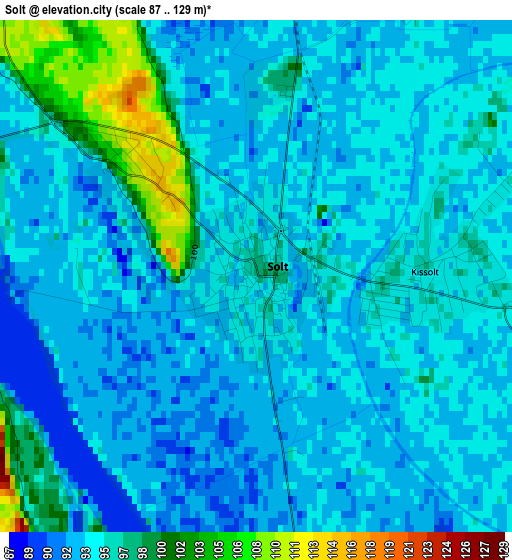
Below is the Elevation map of Solt, which displays elevation range with different colors. Scale of the first map is from 87 to 129 m (285 to 423 ft) with average elevation of 94.8 meters (=311 ft) [note 1]
These maps also provides idea of topography and contour of this city, they are displayed at different zoom levels. More info about maps, scale and edge coordinates you can find below images.
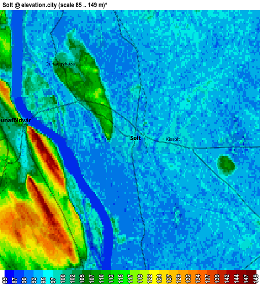
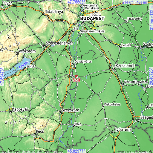
| \ | Map #1 | Map #2 | Topo.Map |
| Scale [m] | 87..129 m | 85..149 m | × |
| Scale [ft] | 285..423 ft | 279..489 ft | × |
| Average | 94.8 m = 311 ft | 98.5 m = 323 ft | × |
| Width | 6.69 km = 4.2 mi | 13.38 km = 8.3 mi | 214.1 km = 133 mi |
| Height | 6.69 km = 4.2 mi | 13.38 km = 8.3 mi | 214.1 km = 133 mi |
| ↑Max Latitude | 46.831084° | 46.861141° | 47.75503° |
| Latitude at center | 46.80101° | 46.80101° | 46.80101° |
| ↓Min Latitude | 46.77092° | 46.740812° | 45.82977° |
| ← Min Longitude | 18.957035° | 18.913089° | 17.59473° |
| Longitude center | 19.00098° | 19.00098° | 19.00098° |
| →Max Longitude | 19.044925° | 19.088871° | 20.40723° |
Nearby cities:
Cities around Solt sort by population:
• Dunaújváros elevation 146 m
18.8 km,  345°
345°
• Dunaföldvár 132 m
5.6 km,  276°
276°
• Szabadszállás 97 m
18.8 km,  63°
63°
• Dunavecse 119 m
12.9 km, 349°
• Harta 87 m
11.7 km,  168°
168°
• Dunapataj 94 m
17.5 km,  181°
181°
• Baracs 102 m
11.5 km,  321°
321°
• Bölcske 99 m
7.1 km,  200°
200°
• Előszállás 107 m
13.1 km, 284°
• Fülöpszállás 96 m
18.1 km,  83°
83°
• Apostag 97 m
9.5 km,  341°
341°
• Madocsa 95 m
13 km,  194°
194°
Multilingual:
 En español:
Solt elevación 87 m.
 En France:
Solt élévation 87 m.


Sources and notes:
- [note 1] Map square and city borders are not equal. Map elevation data is calculated only from area inside that square.
- [src 1] Elevation data from geonames database provided with same terms of usage.
- [src 2] The elevation map of Solt is generated using elevation data from NASA's 3 arcsec (90m) resolution SRTM data.
- [src 3] Base (background) map © OpenStreetMap contributors tiles are generated by Geofabrik and OpenTopoMap.
Copyright & License:
This Solt Elevation Map is licensed under CC BY-SA. You may reuse any part from this page, if you give a proper credit by linking to this URL:
 More info on terms of use page.