Szárliget elevation
Szárliget (Fejér), Hungary elevation is 236 meters and Szárliget elevation in feet is 774 ft above sea level [src 1]. Szárliget is a populated place (feature code) with elevation that is 107 meters (351 ft) bigger than average city elevation in Hungary.
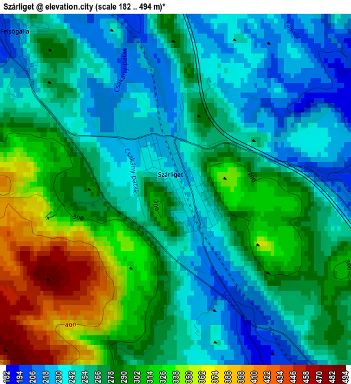
Below is the Elevation map of Szárliget, which displays elevation range with different colors. Scale of the first map is from 182 to 494 m (597 to 1621 ft) with average elevation of 274.4 meters (=900 ft) [note 1]
These maps also provides idea of topography and contour of this city, they are displayed at different zoom levels. More info about maps, scale and edge coordinates you can find below images.
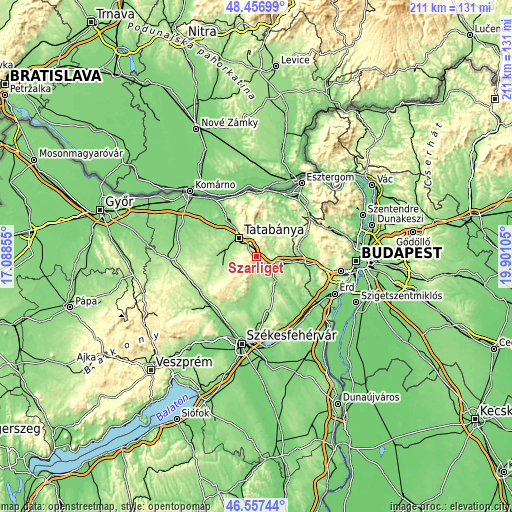
| \ | Map #1 | Topo.Map |
| Scale [m] | 182..494 m | × |
| Scale [ft] | 597..1621 ft | × |
| Average | 274.4 m = 900 ft | × |
| Width | 6.6 km = 4.1 mi | 211.2 km = 131.2 mi |
| Height | 6.6 km = 4.1 mi | 211.2 km = 131.2 mi |
| ↑Max Latitude | 47.545482° | 48.45699° |
| Latitude at center | 47.51581° | 47.51581° |
| ↓Min Latitude | 47.486122° | 46.55744° |
| ← Min Longitude | 18.450855° | 17.08855° |
| Longitude center | 18.4948° | 18.4948° |
| →Max Longitude | 18.538745° | 19.90105° |
Nearby cities:
Cities around Szárliget sort by population:
• Tatabánya elevation 146 m
10.8 km,  315°
315°
• Oroszlány 182 m
14.1 km,  256°
256°
• Bicske 164 m
11.7 km,  107°
107°
• Csákvár 143 m
14 km,  189°
189°
• Zsámbék 168 m
17.3 km,  78°
78°
• Környe 164 m
13.5 km,  284°
284°
• Tarján 194 m
10.6 km,  6°
6°
• Vértesszőlős 157 m
14.5 km, 323°
• Mány 184 m
12.3 km, 80°
• Bajna 199 m
17.2 km,  26°
26°
• Kecskéd 167 m
13.9 km,  273°
273°
• Tardos 304 m
16.7 km,  346°
346°
Multilingual:
 En español:
Szárliget elevación 236 m.
 En France:
Szárliget élévation 236 m.
 Auf Deutsch:
Szárliget höhe über dem Meeresspiegel ist 236 m.

Sources and notes:
- [note 1] Map square and city borders are not equal. Map elevation data is calculated only from area inside that square.
- [src 1] Elevation data from geonames database provided with same terms of usage.
- [src 2] The elevation map of Szárliget is generated using elevation data from NASA's 3 arcsec (90m) resolution SRTM data.
- [src 3] Base (background) map © OpenStreetMap contributors tiles are generated by Geofabrik and OpenTopoMap.
Copyright & License:
This Szárliget Elevation Map is licensed under CC BY-SA. You may reuse any part from this page, if you give a proper credit by linking to this URL:
 More info on terms of use page.