Szombathely elevation
Szombathely (Vas), Hungary elevation is 215 meters and Szombathely elevation in feet is 705 ft above sea level [src 1]. Szombathely is a seat of a first-order administrative division (feature code) with elevation that is 86 meters (282 ft) bigger than average city elevation in Hungary.
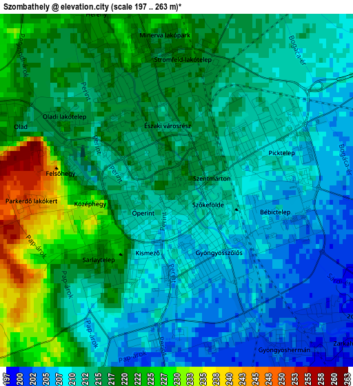
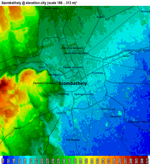
Below is the Elevation map of Szombathely, which displays elevation range with different colors. Scale of the first map is from 197 to 263 m (646 to 863 ft) with average elevation of 214.5 meters (=704 ft) [note 1]
These maps also provides idea of topography and contour of this city, they are displayed at different zoom levels. More info about maps, scale and edge coordinates you can find below images.
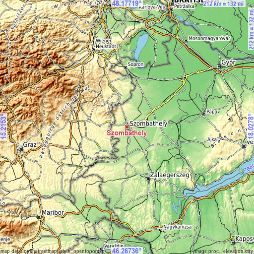
| \ | Map #1 | Map #2 | Topo.Map |
| Scale [m] | 197..263 m | 186..313 m | × |
| Scale [ft] | 646..863 ft | 610..1027 ft | × |
| Average | 214.5 m = 704 ft | 219.8 m = 721 ft | × |
| Width | 6.64 km = 4.1 mi | 13.27 km = 8.2 mi | 212.4 km = 132 mi |
| Height | 6.64 km = 4.1 mi | 13.27 km = 8.2 mi | 212.3 km = 131.9 mi |
| ↑Max Latitude | 47.260712° | 47.290528° | 48.17719° |
| Latitude at center | 47.23088° | 47.23088° | 47.23088° |
| ↓Min Latitude | 47.201031° | 47.171165° | 46.26736° |
| ← Min Longitude | 16.577605° | 16.533659° | 15.2153° |
| Longitude center | 16.62155° | 16.62155° | 16.62155° |
| →Max Longitude | 16.665495° | 16.709441° | 18.0278° |
Nearby cities:
Cities around Szombathely sort by population:
• Sárvár elevation 158 m
23.8 km,  83°
83°
• Körmend 192 m
24.5 km,  182°
182°
• Kőszeg 277 m
18.6 km,  340°
340°
• Celldömölk 136 m
40 km,  85°
85°
• Vasvár 202 m
24.3 km,  146°
146°
• Csepreg 180 m
20 km,  19°
19°
• Vép 191 m
7.6 km, 90°
• Bük 178 m
19.7 km,  29°
29°
• Répcelak 140 m
36.6 km,  54°
54°
• Gencsapáti 228 m
6.3 km, 342°
• Táplánszentkereszt 193 m
6.9 km,  125°
125°
• Ják 206 m
10.3 km,  197°
197°
Multilingual:
 En español:
Szombathely elevación 215 m.
 En France:
Szombathely élévation 215 m.
 Auf Deutsch:
Szombathely höhe über dem Meeresspiegel ist 215 m.

Sources and notes:
- [note 1] Map square and city borders are not equal. Map elevation data is calculated only from area inside that square.
- [src 1] Elevation data from geonames database provided with same terms of usage.
- [src 2] The elevation map of Szombathely is generated using elevation data from NASA's 3 arcsec (90m) resolution SRTM data.
- [src 3] Base (background) map © OpenStreetMap contributors tiles are generated by Geofabrik and OpenTopoMap.
Copyright & License:
This Szombathely Elevation Map is licensed under CC BY-SA. You may reuse any part from this page, if you give a proper credit by linking to this URL:
 More info on terms of use page.