Borgne elevation
Borgne (Nord, Arrondissement du Borgne), Haiti elevation is 10 meters and Borgne elevation in feet is 33 ft above sea level [src 1]. Borgne is a populated place (feature code) with elevation that is 133 meters (436 ft) smaller than average city elevation in Haiti.
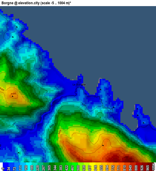
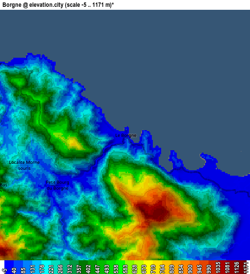
Below is the Elevation map of Borgne, which displays elevation range with different colors. Scale of the first map is from -5 to 1004 m (-16 to 3294 ft) with average elevation of 279.4 meters (=917 ft) [note 1]
These maps also provides idea of topography and contour of this city, they are displayed at different zoom levels. More info about maps, scale and edge coordinates you can find below images.
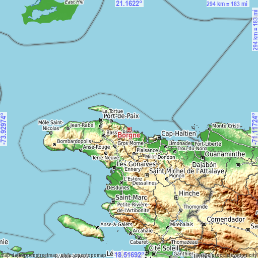
| \ | Map #1 | Map #2 | Topo.Map |
| Scale [m] | -5..1004 m | -5..1171 m | × |
| Scale [ft] | -16..3294 ft | -16..3842 ft | × |
| Average | 279.4 m = 917 ft | 321.9 m = 1056 ft | × |
| Width | 9.19 km = 5.7 mi | 18.38 km = 11.4 mi | 294.1 km = 182.7 mi |
| Height | 9.19 km = 5.7 mi | 18.38 km = 11.4 mi | 294.1 km = 182.7 mi |
| ↑Max Latitude | 19.8864° | 19.92772° | 21.1622° |
| Latitude at center | 19.84507° | 19.84507° | 19.84507° |
| ↓Min Latitude | 19.803729° | 19.762377° | 18.51692° |
| ← Min Longitude | -72.567435° | -72.611381° | -73.92974° |
| Longitude center | -72.52349° | -72.52349° | -72.52349° |
| →Max Longitude | -72.479545° | -72.435599° | -71.11724° |
Nearby cities:
Cities around Borgne sort by population:
• Port-de-Paix elevation 37 m
33.8 km,  288°
288°
• Okap 7 m
35.3 km,  105°
105°
• Ti Port-de-Paix 75 m
33.8 km, 286°
• Lenbe 34 m
19.9 km,  140°
140°
• Saint-Louis du Nord 10 m
22.9 km,  295°
295°
• Gros Morne 219 m
25.2 km,  219°
219°
• Pilate 276 m
20 km,  188°
188°
• Plaisance 387 m
28 km,  168°
168°
• Acul du Nord 61 m
28.1 km,  130°
130°
• Port-Margot 37 m
14.3 km, 136°
• Plaine du Nord 20 m
32.5 km, 125°
• Fond Bassin Bleu 142 m
29.4 km,  258°
258°
Multilingual:
 En español:
Borgne elevación 10 m.
 En France:
Borgne élévation 10 m.


Sources and notes:
- [note 1] Map square and city borders are not equal. Map elevation data is calculated only from area inside that square.
- [src 1] Elevation data from geonames database provided with same terms of usage.
- [src 2] The elevation map of Borgne is generated using elevation data from NASA's 3 arcsec (90m) resolution SRTM data.
- [src 3] Base (background) map © OpenStreetMap contributors tiles are generated by Geofabrik and OpenTopoMap.
Copyright & License:
This Borgne Elevation Map is licensed under CC BY-SA. You may reuse any part from this page, if you give a proper credit by linking to this URL:
 More info on terms of use page.