Port-de-Paix elevation
Port-de-Paix (Nord-Ouest, Arrondissement de Port-de-Paix), Haiti elevation is 37 meters and Port-de-Paix elevation in feet is 121 ft above sea level [src 1]. Port-de-Paix is a seat of a first-order administrative division (feature code) with elevation that is 106 meters (348 ft) smaller than average city elevation in Haiti.
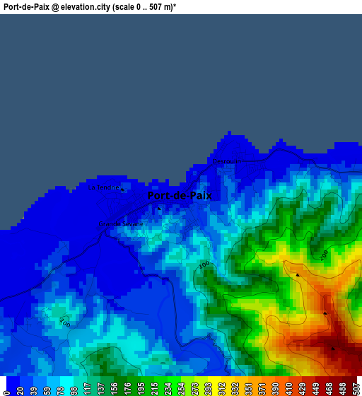
Below is the Elevation map of Port-de-Paix, which displays elevation range with different colors. Scale of the first map is from 0 to 507 m (0 to 1663 ft) with average elevation of 109.8 meters (=360 ft) [note 1]
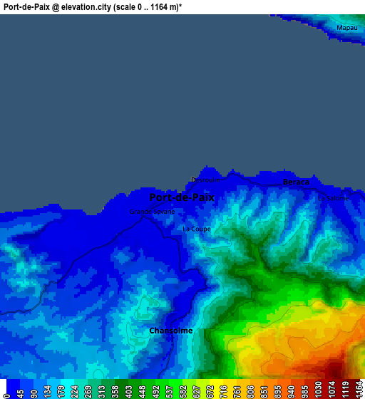
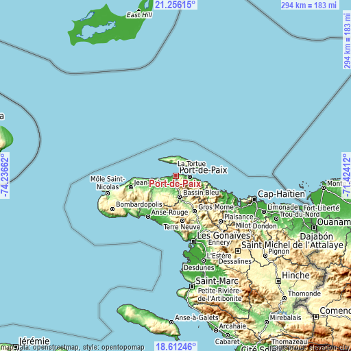
These maps also provides idea of topography and contour of this city, they are displayed at different zoom levels. More info about maps, scale and edge coordinates you can find below images.
| \ | Map #1 | Map #2 | Topo.Map |
| Scale [m] | 0..507 m | 0..1164 m | × |
| Scale [ft] | 0..1663 ft | 0..3819 ft | × |
| Average | 109.8 m = 360 ft | 229.2 m = 752 ft | × |
| Width | 9.19 km = 5.7 mi | 18.37 km = 11.4 mi | 294 km = 182.7 mi |
| Height | 9.19 km = 5.7 mi | 18.37 km = 11.4 mi | 294 km = 182.7 mi |
| ↑Max Latitude | 19.981145° | 20.02244° | 21.25615° |
| Latitude at center | 19.93984° | 19.93984° | 19.93984° |
| ↓Min Latitude | 19.898524° | 19.857197° | 18.61246° |
| ← Min Longitude | -72.874315° | -72.918261° | -74.23662° |
| Longitude center | -72.83037° | -72.83037° | -72.83037° |
| →Max Longitude | -72.786425° | -72.742479° | -71.42412° |
Nearby cities:
Cities around Port-de-Paix sort by population:
• Ti Port-de-Paix elevation 75 m
0.8 km,  203°
203°
• Saint-Louis du Nord 10 m
11.4 km,  93°
93°
• Gros Morne 219 m
33.9 km,  151°
151°
• Jean-Rabel 68 m
38.9 km,  255°
255°
• Anse Rouge 15 m
41.4 km,  214°
214°
• Borgne 10 m
33.8 km,  108°
108°
• Pilate 276 m
42 km,  136°
136°
• Arcahaie 189 m
16.4 km, 213°
• Port-Margot 37 m
46.8 km,  116°
116°
• Baie de Henne 8 m
50.2 km,  232°
232°
• Petite Anse 6 m
48.4 km,  224°
224°
• Fond Bassin Bleu 142 m
16.5 km,  168°
168°
Multilingual:
 En español:
Port-de-Paix elevación 37 m.
 En France:
Port-de-Paix élévation 37 m.
 Auf Deutsch:
Port-de-Paix höhe über dem Meeresspiegel ist 37 m.

Sources and notes:
- [note 1] Map square and city borders are not equal. Map elevation data is calculated only from area inside that square.
- [src 1] Elevation data from geonames database provided with same terms of usage.
- [src 2] The elevation map of Port-de-Paix is generated using elevation data from NASA's 3 arcsec (90m) resolution SRTM data.
- [src 3] Base (background) map © OpenStreetMap contributors tiles are generated by Geofabrik and OpenTopoMap.
Copyright & License:
This Port-de-Paix Elevation Map is licensed under CC BY-SA. You may reuse any part from this page, if you give a proper credit by linking to this URL:
 More info on terms of use page.