Lenbe elevation
Lenbe (Nord), Haiti elevation is 34 meters and Lenbe elevation in feet is 112 ft above sea level [src 1]. Lenbe is a populated place (feature code) with elevation that is 109 meters (358 ft) smaller than average city elevation in Haiti.
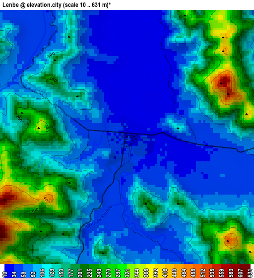
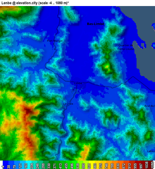
Below is the Elevation map of Lenbe, which displays elevation range with different colors. Scale of the first map is from 10 to 631 m (33 to 2070 ft) with average elevation of 125.4 meters (=411 ft) [note 1]
These maps also provides idea of topography and contour of this city, they are displayed at different zoom levels. More info about maps, scale and edge coordinates you can find below images.
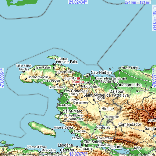
| \ | Map #1 | Map #2 | Topo.Map |
| Scale [m] | 10..631 m | -4..1080 m | × |
| Scale [ft] | 33..2070 ft | -13..3543 ft | × |
| Average | 125.4 m = 411 ft | 203.9 m = 669 ft | × |
| Width | 9.2 km = 5.7 mi | 18.4 km = 11.4 mi | 294.4 km = 182.9 mi |
| Height | 9.2 km = 5.7 mi | 18.4 km = 11.4 mi | 294.4 km = 182.9 mi |
| ↑Max Latitude | 19.747396° | 19.788752° | 21.02434° |
| Latitude at center | 19.70603° | 19.70603° | 19.70603° |
| ↓Min Latitude | 19.664653° | 19.623265° | 18.37676° |
| ← Min Longitude | -72.447305° | -72.491251° | -73.80961° |
| Longitude center | -72.40336° | -72.40336° | -72.40336° |
| →Max Longitude | -72.359415° | -72.315469° | -70.99711° |
Nearby cities:
Cities around Lenbe sort by population:
• Okap elevation 7 m
22.3 km,  74°
74°
• Milot 102 m
22.7 km,  118°
118°
• Dondon 427 m
26 km,  139°
139°
• Borgne 10 m
19.9 km,  320°
320°
• Pilate 276 m
16.2 km,  254°
254°
• Plaisance 387 m
13.9 km,  210°
210°
• Acul du Nord 61 m
9.2 km,  107°
107°
• Port-Margot 37 m
5.8 km,  331°
331°
• Plaine du Nord 20 m
14.4 km,  102°
102°
• Marmelade 747 m
21.4 km,  168°
168°
• Ennery 329 m
26.2 km,  199°
199°
• Quartier Morin 18 m
25.8 km,  92°
92°
Multilingual:
 En español:
Lenbe elevación 34 m.
 En France:
Lenbe élévation 34 m.


Sources and notes:
- [note 1] Map square and city borders are not equal. Map elevation data is calculated only from area inside that square.
- [src 1] Elevation data from geonames database provided with same terms of usage.
- [src 2] The elevation map of Lenbe is generated using elevation data from NASA's 3 arcsec (90m) resolution SRTM data.
- [src 3] Base (background) map © OpenStreetMap contributors tiles are generated by Geofabrik and OpenTopoMap.
Copyright & License:
This Lenbe Elevation Map is licensed under CC BY-SA. You may reuse any part from this page, if you give a proper credit by linking to this URL:
 More info on terms of use page.