Dondon elevation
Dondon (Nord, Arrondissement de Saint-Raphaël), Haiti elevation is 427 meters and Dondon elevation in feet is 1401 ft above sea level [src 1]. Dondon is a populated place (feature code) with elevation that is 284 meters (932 ft) bigger than average city elevation in Haiti.
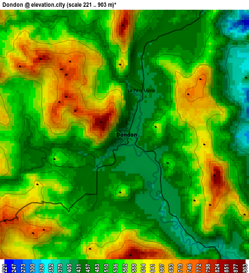
Below is the Elevation map of Dondon, which displays elevation range with different colors. Scale of the first map is from 221 to 903 m (725 to 2963 ft) with average elevation of 539.3 meters (=1769 ft) [note 1]
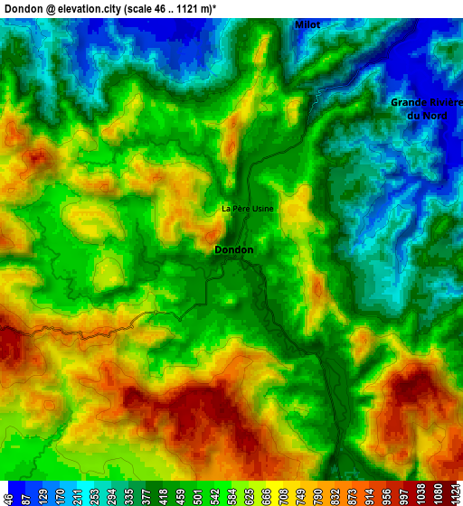
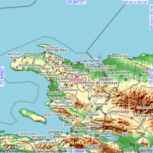
These maps also provides idea of topography and contour of this city, they are displayed at different zoom levels. More info about maps, scale and edge coordinates you can find below images.
| \ | Map #1 | Map #2 | Topo.Map |
| Scale [m] | 221..903 m | 46..1121 m | × |
| Scale [ft] | 725..2963 ft | 151..3678 ft | × |
| Average | 539.3 m = 1769 ft | 521.6 m = 1711 ft | × |
| Width | 9.21 km = 5.7 mi | 18.42 km = 11.4 mi | 294.7 km = 183.1 mi |
| Height | 9.21 km = 5.7 mi | 18.42 km = 11.4 mi | 294.7 km = 183.1 mi |
| ↑Max Latitude | 19.568752° | 19.610154° | 20.84717° |
| Latitude at center | 19.52734° | 19.52734° | 19.52734° |
| ↓Min Latitude | 19.485917° | 19.444483° | 18.19664° |
| ← Min Longitude | -72.287315° | -72.331261° | -73.64962° |
| Longitude center | -72.24337° | -72.24337° | -72.24337° |
| →Max Longitude | -72.199425° | -72.155479° | -70.83712° |
Nearby cities:
Cities around Dondon sort by population:
• Saint-Raphaël elevation 377 m
10.9 km,  154°
154°
• Trou du Nord 40 m
25 km,  66°
66°
• Grande Rivière du Nord 69 m
9.6 km,  54°
54°
• Milot 102 m
9.5 km,  19°
19°
• Plaisance 387 m
25 km,  288°
288°
• Limonade 20 m
20.2 km,  38°
38°
• Acul du Nord 61 m
18.8 km,  334°
334°
• Plaine du Nord 20 m
16.9 km,  350°
350°
• Marmelade 747 m
12.4 km,  264°
264°
• Bahon 119 m
14.9 km,  115°
115°
• Ranquitte 403 m
21.2 km,  126°
126°
• Quartier Morin 18 m
20.9 km,  25°
25°
Multilingual:
 En español:
Dondon elevación 427 m.
 En France:
Dondon élévation 427 m.


Sources and notes:
- [note 1] Map square and city borders are not equal. Map elevation data is calculated only from area inside that square.
- [src 1] Elevation data from geonames database provided with same terms of usage.
- [src 2] The elevation map of Dondon is generated using elevation data from NASA's 3 arcsec (90m) resolution SRTM data.
- [src 3] Base (background) map © OpenStreetMap contributors tiles are generated by Geofabrik and OpenTopoMap.
Copyright & License:
This Dondon Elevation Map is licensed under CC BY-SA. You may reuse any part from this page, if you give a proper credit by linking to this URL:
 More info on terms of use page.