Biskupija elevation
Biskupija (Šibensko-Kniniska), Croatia elevation is 344 meters and Biskupija elevation in feet is 1129 ft above sea level [src 1]. Biskupija is a seat of a second-order administrative division (feature code) with elevation that is 190 meters (623 ft) bigger than average city elevation in Croatia.
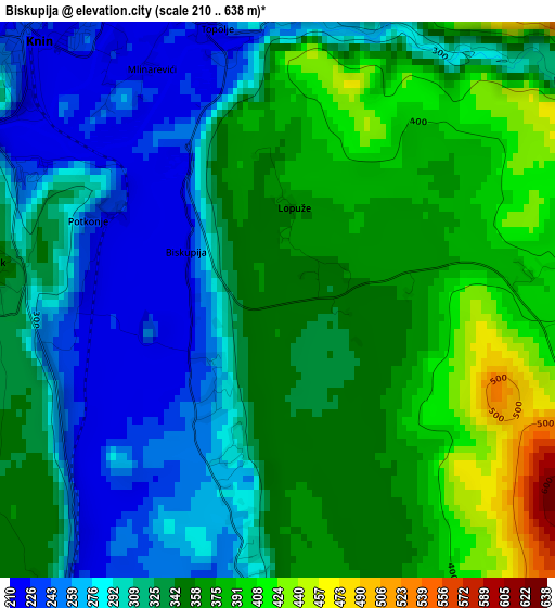
Below is the Elevation map of Biskupija, which displays elevation range with different colors. Scale of the first map is from 210 to 638 m (689 to 2093 ft) with average elevation of 330.1 meters (=1083 ft) [note 1]
These maps also provides idea of topography and contour of this city, they are displayed at different zoom levels. More info about maps, scale and edge coordinates you can find below images.
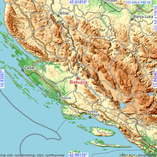
| \ | Map #1 | Topo.Map |
| Scale [m] | 210..638 m | × |
| Scale [ft] | 689..2093 ft | × |
| Average | 330.1 m = 1083 ft | × |
| Width | 7.03 km = 4.4 mi | 224.9 km = 139.7 mi |
| Height | 7.03 km = 4.4 mi | 224.9 km = 139.7 mi |
| ↑Max Latitude | 44.042987° | 45.01414° |
| Latitude at center | 44.01139° | 44.01139° |
| ↓Min Latitude | 43.979776° | 42.99139° |
| ← Min Longitude | 16.193275° | 14.83097° |
| Longitude center | 16.23722° | 16.23722° |
| →Max Longitude | 16.281165° | 17.64347° |
Nearby cities:
Cities around Biskupija sort by population:
• Knin elevation 230 m
4.6 km,  315°
315°
• Drniš 295 m
17.8 km,  201°
201°
• Kistanje 239 m
22 km,  261°
261°
• Skradin 2 m
32.9 km,  229°
229°
• Bilice 9 m
38.2 km, 229°
• Lišane Ostrovičke 154 m
37.3 km, 262°
• Unešić 358 m
30.4 km,  187°
187°
• Ervenik 132 m
25.3 km,  292°
292°
• Ružić 308 m
20.9 km,  175°
175°
• Civljane 382 m
14.7 km,  117°
117°
• Oklaj 261 m
14.1 km,  241°
241°
• Kijevo 479 m
10.3 km,  111°
111°
Multilingual:
 En español:
Biskupija elevación 344 m.
 En France:
Biskupija élévation 344 m.
 Auf Deutsch:
Biskupija höhe über dem Meeresspiegel ist 344 m.

Sources and notes:
- [note 1] Map square and city borders are not equal. Map elevation data is calculated only from area inside that square.
- [src 1] Elevation data from geonames database provided with same terms of usage.
- [src 2] The elevation map of Biskupija is generated using elevation data from NASA's 3 arcsec (90m) resolution SRTM data.
- [src 3] Base (background) map © OpenStreetMap contributors tiles are generated by Geofabrik and OpenTopoMap.
Copyright & License:
This Biskupija Elevation Map is licensed under CC BY-SA. You may reuse any part from this page, if you give a proper credit by linking to this URL:
 More info on terms of use page.