Ervenik elevation
Ervenik (Šibensko-Kniniska), Croatia elevation is 132 meters and Ervenik elevation in feet is 433 ft above sea level [src 1]. Ervenik is a seat of a second-order administrative division (feature code) with elevation that is 22 meters (72 ft) smaller than average city elevation in Croatia.
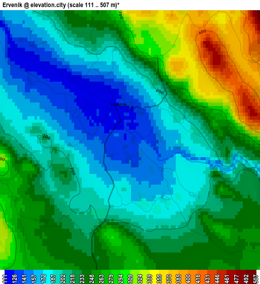
Below is the Elevation map of Ervenik, which displays elevation range with different colors. Scale of the first map is from 111 to 507 m (364 to 1663 ft) with average elevation of 228.3 meters (=749 ft) [note 1]
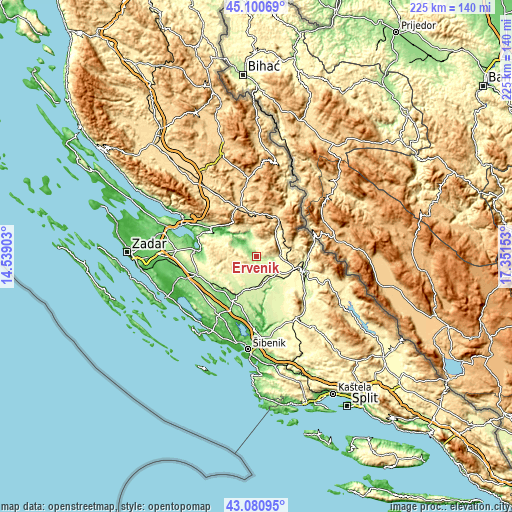
These maps also provides idea of topography and contour of this city, they are displayed at different zoom levels. More info about maps, scale and edge coordinates you can find below images.
| \ | Map #1 | Topo.Map |
| Scale [m] | 111..507 m | × |
| Scale [ft] | 364..1663 ft | × |
| Average | 228.3 m = 749 ft | × |
| Width | 7.02 km = 4.4 mi | 224.6 km = 139.6 mi |
| Height | 7.02 km = 4.4 mi | 224.6 km = 139.6 mi |
| ↑Max Latitude | 44.13099° | 45.10069° |
| Latitude at center | 44.09944° | 44.09944° |
| ↓Min Latitude | 44.067873° | 43.08095° |
| ← Min Longitude | 15.901335° | 14.53903° |
| Longitude center | 15.94528° | 15.94528° |
| →Max Longitude | 15.989225° | 17.35153° |
Nearby cities:
Cities around Ervenik sort by population:
• Knin elevation 230 m
21.1 km,  108°
108°
• Gračac 561 m
23.5 km,  340°
340°
• Benkovac 180 m
27.5 km,  254°
254°
• Kistanje 239 m
13.1 km,  173°
173°
• Gornji Karin 23 m
25.2 km,  279°
279°
• Kruševo 227 m
25.3 km,  291°
291°
• Obrovac 13 m
23.8 km,  298°
298°
• Skradin 2 m
31.1 km,  183°
183°
• Stankovci 286 m
28.8 km,  222°
222°
• Biskupija 344 m
25.3 km, 112°
• Lišane Ostrovičke 154 m
20 km, 223°
• Oklaj 261 m
19.8 km,  146°
146°
Multilingual:
 En español:
Ervenik elevación 132 m.
 En France:
Ervenik élévation 132 m.


Sources and notes:
- [note 1] Map square and city borders are not equal. Map elevation data is calculated only from area inside that square.
- [src 1] Elevation data from geonames database provided with same terms of usage.
- [src 2] The elevation map of Ervenik is generated using elevation data from NASA's 3 arcsec (90m) resolution SRTM data.
- [src 3] Base (background) map © OpenStreetMap contributors tiles are generated by Geofabrik and OpenTopoMap.
Copyright & License:
This Ervenik Elevation Map is licensed under CC BY-SA. You may reuse any part from this page, if you give a proper credit by linking to this URL:
 More info on terms of use page.