Benkovac elevation
Benkovac (Zadarska), Croatia elevation is 180 meters and Benkovac elevation in feet is 591 ft above sea level [src 1]. Benkovac is a seat of a second-order administrative division (feature code) with elevation that is 26 meters (85 ft) bigger than average city elevation in Croatia.
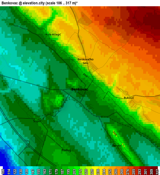
Below is the Elevation map of Benkovac, which displays elevation range with different colors. Scale of the first map is from 106 to 317 m (348 to 1040 ft) with average elevation of 200.9 meters (=659 ft) [note 1]
These maps also provides idea of topography and contour of this city, they are displayed at different zoom levels. More info about maps, scale and edge coordinates you can find below images.
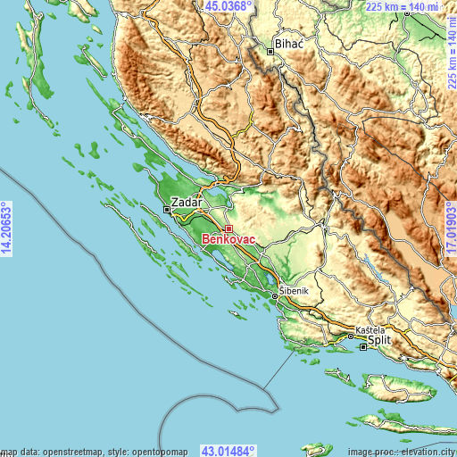
| \ | Map #1 | Topo.Map |
| Scale [m] | 106..317 m | × |
| Scale [ft] | 348..1040 ft | × |
| Average | 200.9 m = 659 ft | × |
| Width | 7.03 km = 4.4 mi | 224.8 km = 139.7 mi |
| Height | 7.03 km = 4.4 mi | 224.8 km = 139.7 mi |
| ↑Max Latitude | 44.066025° | 45.0368° |
| Latitude at center | 44.03444° | 44.03444° |
| ↓Min Latitude | 44.002838° | 43.01484° |
| ← Min Longitude | 15.568835° | 14.20653° |
| Longitude center | 15.61278° | 15.61278° |
| →Max Longitude | 15.656725° | 17.01903° |
Nearby cities:
Cities around Benkovac sort by population:
• Biograd na Moru elevation 17 m
16.4 km,  231°
231°
• Pakoštane 16 m
15.9 km,  211°
211°
• Sveti Filip i Jakov 44 m
16.5 km,  242°
242°
• Pridraga 85 m
15.2 km,  345°
345°
• Turanj 15 m
17.6 km,  246°
246°
• Gornji Karin 23 m
11.4 km,  8°
8°
• Polača 118 m
7.8 km,  256°
256°
• Kruševo 227 m
16.8 km, 10°
• Novigrad 60 m
17.3 km,  344°
344°
• Stankovci 286 m
15.5 km,  153°
153°
• Lišane Ostrovičke 154 m
14.8 km,  119°
119°
• Škabrnje 109 m
14.2 km,  296°
296°
Multilingual:
 En español:
Benkovac elevación 180 m.
 En France:
Benkovac élévation 180 m.
 Auf Deutsch:
Benkovac höhe über dem Meeresspiegel ist 180 m.

Sources and notes:
- [note 1] Map square and city borders are not equal. Map elevation data is calculated only from area inside that square.
- [src 1] Elevation data from geonames database provided with same terms of usage.
- [src 2] The elevation map of Benkovac is generated using elevation data from NASA's 3 arcsec (90m) resolution SRTM data.
- [src 3] Base (background) map © OpenStreetMap contributors tiles are generated by Geofabrik and OpenTopoMap.
Copyright & License:
This Benkovac Elevation Map is licensed under CC BY-SA. You may reuse any part from this page, if you give a proper credit by linking to this URL:
 More info on terms of use page.