Bistrinci elevation
Bistrinci (Osječko-Baranjska, Belišće), Croatia elevation is 93 meters and Bistrinci elevation in feet is 305 ft above sea level [src 1]. Bistrinci is a populated place (feature code) with elevation that is 61 meters (200 ft) smaller than average city elevation in Croatia.
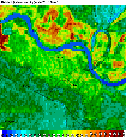
Below is the Elevation map of Bistrinci, which displays elevation range with different colors. Scale of the first map is from 78 to 108 m (256 to 354 ft) with average elevation of 89.9 meters (=295 ft) [note 1]
These maps also provides idea of topography and contour of this city, they are displayed at different zoom levels. More info about maps, scale and edge coordinates you can find below images.
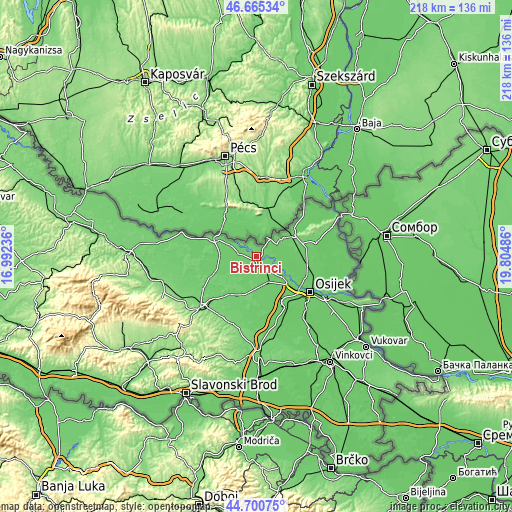
| \ | Map #1 | Topo.Map |
| Scale [m] | 78..108 m | × |
| Scale [ft] | 256..354 ft | × |
| Average | 89.9 m = 295 ft | × |
| Width | 6.83 km = 4.2 mi | 218.4 km = 135.7 mi |
| Height | 6.83 km = 4.2 mi | 218.4 km = 135.7 mi |
| ↑Max Latitude | 45.722358° | 46.66534° |
| Latitude at center | 45.69167° | 45.69167° |
| ↓Min Latitude | 45.660965° | 44.70075° |
| ← Min Longitude | 18.354665° | 16.99236° |
| Longitude center | 18.39861° | 18.39861° |
| →Max Longitude | 18.442555° | 19.80486° |
Nearby cities:
Cities around Bistrinci sort by population:
• Beli Manastir elevation 94 m
18.1 km,  61°
61°
• Valpovo 88 m
3.8 km,  155°
155°
• Belišće 89 m
1.4 km, 156°
• Josipovac 87 m
18.7 km,  130°
130°
• Petrijevci 89 m
13.8 km, 129°
• Bizovac 88 m
12 km, 156°
• Koška 95 m
18.5 km,  208°
208°
• Ladimirevci 86 m
8.3 km,  152°
152°
• Jagodnjak 88 m
13.9 km,  86°
86°
• Marjanci 95 m
8.7 km,  251°
251°
• Petlovac 91 m
12.5 km,  53°
53°
• Donji Miholjac 99 m
19.5 km,  293°
293°
Multilingual:
 En español:
Bistrinci elevación 93 m.
 En France:
Bistrinci élévation 93 m.
 Auf Deutsch:
Bistrinci höhe über dem Meeresspiegel ist 93 m.

Sources and notes:
- [note 1] Map square and city borders are not equal. Map elevation data is calculated only from area inside that square.
- [src 1] Elevation data from geonames database provided with same terms of usage.
- [src 2] The elevation map of Bistrinci is generated using elevation data from NASA's 3 arcsec (90m) resolution SRTM data.
- [src 3] Base (background) map © OpenStreetMap contributors tiles are generated by Geofabrik and OpenTopoMap.
Copyright & License:
This Bistrinci Elevation Map is licensed under CC BY-SA. You may reuse any part from this page, if you give a proper credit by linking to this URL:
 More info on terms of use page.