Perušić elevation
Perušić (Ličko-Senjska), Croatia elevation is 579 meters and Perušić elevation in feet is 1900 ft above sea level [src 1]. Perušić is a seat of a second-order administrative division (feature code) with elevation that is 425 meters (1394 ft) bigger than average city elevation in Croatia.
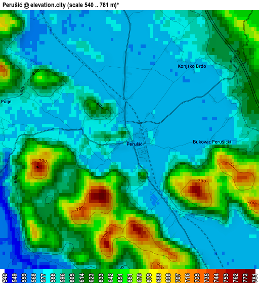
Below is the Elevation map of Perušić, which displays elevation range with different colors. Scale of the first map is from 540 to 781 m (1772 to 2562 ft) with average elevation of 605.3 meters (=1986 ft) [note 1]
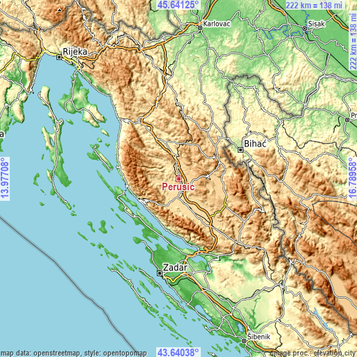
These maps also provides idea of topography and contour of this city, they are displayed at different zoom levels. More info about maps, scale and edge coordinates you can find below images.
| \ | Map #1 | Topo.Map |
| Scale [m] | 540..781 m | × |
| Scale [ft] | 1772..2562 ft | × |
| Average | 605.3 m = 1986 ft | × |
| Width | 6.95 km = 4.3 mi | 222.5 km = 138.3 mi |
| Height | 6.95 km = 4.3 mi | 222.5 km = 138.3 mi |
| ↑Max Latitude | 44.680695° | 45.64125° |
| Latitude at center | 44.64944° | 44.64944° |
| ↓Min Latitude | 44.618168° | 43.64038° |
| ← Min Longitude | 15.339385° | 13.97708° |
| Longitude center | 15.38333° | 15.38333° |
| →Max Longitude | 15.427275° | 16.78958° |
Nearby cities:
Cities around Perušić sort by population:
• Gospić elevation 563 m
11.5 km,  183°
183°
• Otočac 459 m
27 km,  334°
334°
• Popovača 601 m
16.2 km,  265°
265°
• Pag 18 m
34.4 km,  228°
228°
• Lički Osik 575 m
6 km,  147°
147°
• Stari Grad 18 m
35.3 km, 226°
• Karlobag 30 m
28 km,  241°
241°
• Kolan 113 m
37.6 km, 242°
• Lovinac 582 m
37.4 km,  140°
140°
• Udbina 827 m
33 km,  113°
113°
• Korenica 650 m
27.9 km,  67°
67°
• Vrhovine 726 m
22.7 km,  7°
7°
Multilingual:
 En español:
Perušić elevación 579 m.
 En France:
Perušić élévation 579 m.


Sources and notes:
- [note 1] Map square and city borders are not equal. Map elevation data is calculated only from area inside that square.
- [src 1] Elevation data from geonames database provided with same terms of usage.
- [src 2] The elevation map of Perušić is generated using elevation data from NASA's 3 arcsec (90m) resolution SRTM data.
- [src 3] Base (background) map © OpenStreetMap contributors tiles are generated by Geofabrik and OpenTopoMap.
Copyright & License:
This Perušić Elevation Map is licensed under CC BY-SA. You may reuse any part from this page, if you give a proper credit by linking to this URL:
 More info on terms of use page.