Ravna Gora elevation
Ravna Gora (Primorsko-Goranska), Croatia elevation is 792 meters and Ravna Gora elevation in feet is 2598 ft above sea level [src 1]. Ravna Gora is a seat of a second-order administrative division (feature code) with elevation that is 638 meters (2093 ft) bigger than average city elevation in Croatia.
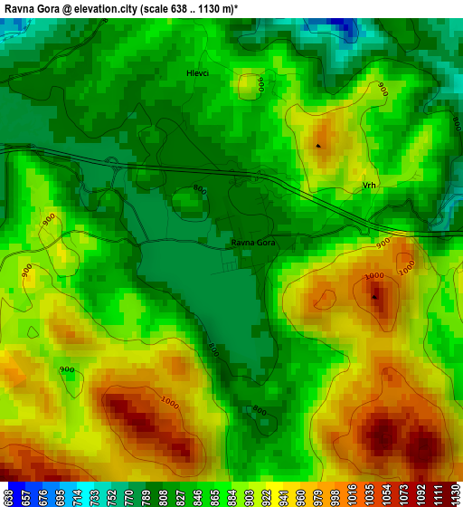
Below is the Elevation map of Ravna Gora, which displays elevation range with different colors. Scale of the first map is from 638 to 1130 m (2093 to 3707 ft) with average elevation of 875.2 meters (=2871 ft) [note 1]
These maps also provides idea of topography and contour of this city, they are displayed at different zoom levels. More info about maps, scale and edge coordinates you can find below images.
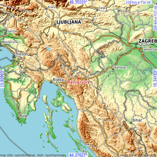
| \ | Map #1 | Topo.Map |
| Scale [m] | 638..1130 m | × |
| Scale [ft] | 2093..3707 ft | × |
| Average | 875.2 m = 2871 ft | × |
| Width | 6.87 km = 4.3 mi | 219.7 km = 136.5 mi |
| Height | 6.87 km = 4.3 mi | 219.7 km = 136.5 mi |
| ↑Max Latitude | 45.403643° | 46.35203° |
| Latitude at center | 45.37278° | 45.37278° |
| ↓Min Latitude | 45.3419° | 44.37627° |
| ← Min Longitude | 14.891335° | 13.52903° |
| Longitude center | 14.93528° | 14.93528° |
| →Max Longitude | 14.979225° | 16.34153° |
Nearby cities:
Cities around Ravna Gora sort by population:
• Ogulin elevation 323 m
25.8 km,  117°
117°
• Crikvenica 53 m
28.9 km,  221°
221°
• Delnice 699 m
11 km,  286°
286°
• Hreljin 290 m
28.1 km,  249°
249°
• Vrbovsko 439 m
11.2 km,  92°
92°
• Bribir 146 m
27.1 km,  209°
209°
• Mrkopalj 822 m
8.9 km, 224°
• Skrad 821 m
6.4 km,  342°
342°
• Fužine 721 m
18.7 km, 246°
• Bosiljevo 264 m
27.8 km,  83°
83°
• Lokve 743 m
14.7 km,  263°
263°
• Brod Moravice 610 m
10.7 km,  16°
16°
Multilingual:
 En español:
Ravna Gora elevación 792 m.
 En France:
Ravna Gora élévation 792 m.
 Auf Deutsch:
Ravna Gora höhe über dem Meeresspiegel ist 792 m.

Sources and notes:
- [note 1] Map square and city borders are not equal. Map elevation data is calculated only from area inside that square.
- [src 1] Elevation data from geonames database provided with same terms of usage.
- [src 2] The elevation map of Ravna Gora is generated using elevation data from NASA's 3 arcsec (90m) resolution SRTM data.
- [src 3] Base (background) map © OpenStreetMap contributors tiles are generated by Geofabrik and OpenTopoMap.
Copyright & License:
This Ravna Gora Elevation Map is licensed under CC BY-SA. You may reuse any part from this page, if you give a proper credit by linking to this URL:
 More info on terms of use page.