Crikvenica elevation
Crikvenica (Primorsko-Goranska, Grad Crikvenica), Croatia elevation is 53 meters and Crikvenica elevation in feet is 174 ft above sea level [src 1]. Crikvenica is a seat of a second-order administrative division (feature code) with elevation that is 101 meters (331 ft) smaller than average city elevation in Croatia.
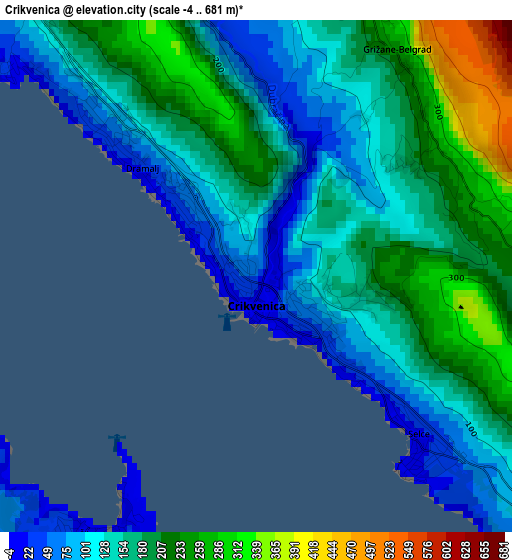
Below is the Elevation map of Crikvenica, which displays elevation range with different colors. Scale of the first map is from -4 to 681 m (-13 to 2234 ft) with average elevation of 163.7 meters (=537 ft) [note 1]
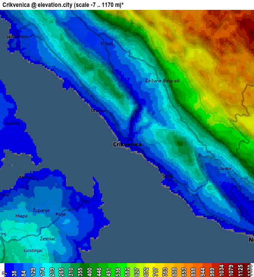
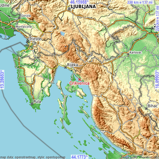
These maps also provides idea of topography and contour of this city, they are displayed at different zoom levels. More info about maps, scale and edge coordinates you can find below images.
| \ | Map #1 | Map #2 | Topo.Map |
| Scale [m] | -4..681 m | -7..1170 m | × |
| Scale [ft] | -13..2234 ft | -23..3839 ft | × |
| Average | 163.7 m = 537 ft | 306.2 m = 1005 ft | × |
| Width | 6.89 km = 4.3 mi | 13.78 km = 8.6 mi | 220.4 km = 136.9 mi |
| Height | 6.89 km = 4.3 mi | 13.78 km = 8.6 mi | 220.4 km = 136.9 mi |
| ↑Max Latitude | 45.208189° | 45.239142° | 46.15988° |
| Latitude at center | 45.17722° | 45.17722° | 45.17722° |
| ↓Min Latitude | 45.146234° | 45.115231° | 44.1773° |
| ← Min Longitude | 14.648835° | 14.604889° | 13.28653° |
| Longitude center | 14.69278° | 14.69278° | 14.69278° |
| →Max Longitude | 14.736725° | 14.780671° | 16.09903° |
Nearby cities:
Cities around Crikvenica sort by population:
• Novi Vinodolski elevation 33 m
9.3 km,  125°
125°
• Kraljevica 14 m
14.5 km,  317°
317°
• Hreljin 290 m
13.8 km,  327°
327°
• Omišalj 87 m
11.4 km,  289°
289°
• Bribir 146 m
5.9 km,  107°
107°
• Selce 12 m
3.2 km,  136°
136°
• Krasica 192 m
18.2 km, 323°
• Jadranovo 59 m
8.4 km, 315°
• Njivice 34 m
12.3 km,  260°
260°
• Vrbnik 20 m
11.4 km,  188°
188°
• Fužine 721 m
14.4 km,  7°
7°
• Dobrinj 179 m
9 km,  231°
231°
Multilingual:
 En español:
Crikvenica elevación 53 m.
 En France:
Crikvenica élévation 53 m.
 Auf Deutsch:
Crikvenica höhe über dem Meeresspiegel ist 53 m.

Sources and notes:
- [note 1] Map square and city borders are not equal. Map elevation data is calculated only from area inside that square.
- [src 1] Elevation data from geonames database provided with same terms of usage.
- [src 2] The elevation map of Crikvenica is generated using elevation data from NASA's 3 arcsec (90m) resolution SRTM data.
- [src 3] Base (background) map © OpenStreetMap contributors tiles are generated by Geofabrik and OpenTopoMap.
Copyright & License:
This Crikvenica Elevation Map is licensed under CC BY-SA. You may reuse any part from this page, if you give a proper credit by linking to this URL:
 More info on terms of use page.