Lokve elevation
Lokve (Primorsko-Goranska), Croatia elevation is 743 meters and Lokve elevation in feet is 2438 ft above sea level [src 1]. Lokve is a seat of a second-order administrative division (feature code) with elevation that is 589 meters (1932 ft) bigger than average city elevation in Croatia.
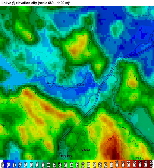
Below is the Elevation map of Lokve, which displays elevation range with different colors. Scale of the first map is from 689 to 1100 m (2260 to 3609 ft) with average elevation of 820.5 meters (=2692 ft) [note 1]
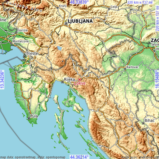
These maps also provides idea of topography and contour of this city, they are displayed at different zoom levels. More info about maps, scale and edge coordinates you can find below images.
| \ | Map #1 | Topo.Map |
| Scale [m] | 689..1100 m | × |
| Scale [ft] | 2260..3609 ft | × |
| Average | 820.5 m = 2692 ft | × |
| Width | 6.87 km = 4.3 mi | 219.7 km = 136.5 mi |
| Height | 6.87 km = 4.3 mi | 219.7 km = 136.5 mi |
| ↑Max Latitude | 45.38976° | 46.33839° |
| Latitude at center | 45.35889° | 45.35889° |
| ↓Min Latitude | 45.328003° | 44.36214° |
| ← Min Longitude | 14.704665° | 13.34236° |
| Longitude center | 14.74861° | 14.74861° |
| →Max Longitude | 14.792555° | 16.15486° |
Nearby cities:
Cities around Lokve sort by population:
• Delnice elevation 699 m
6.1 km,  40°
40°
• Kraljevica 14 m
17 km,  236°
236°
• Hreljin 290 m
14.4 km,  233°
233°
• Bakar 82 m
18 km,  251°
251°
• Cernik 277 m
19.3 km,  264°
264°
• Krasica 192 m
16 km, 250°
• Škrljevo 262 m
17.4 km, 255°
• Jadranovo 59 m
17.5 km,  215°
215°
• Mrkopalj 822 m
9.6 km,  120°
120°
• Skrad 821 m
14.8 km,  58°
58°
• Fužine 721 m
6.5 km,  203°
203°
• Ravna Gora 792 m
14.7 km,  83°
83°
Multilingual:
 En español:
Lokve elevación 743 m.
 En France:
Lokve élévation 743 m.


Sources and notes:
- [note 1] Map square and city borders are not equal. Map elevation data is calculated only from area inside that square.
- [src 1] Elevation data from geonames database provided with same terms of usage.
- [src 2] The elevation map of Lokve is generated using elevation data from NASA's 3 arcsec (90m) resolution SRTM data.
- [src 3] Base (background) map © OpenStreetMap contributors tiles are generated by Geofabrik and OpenTopoMap.
Copyright & License:
This Lokve Elevation Map is licensed under CC BY-SA. You may reuse any part from this page, if you give a proper credit by linking to this URL:
 More info on terms of use page.