Gualaco elevation
Gualaco (Olancho), Honduras elevation is 653 meters and Gualaco elevation in feet is 2142 ft above sea level [src 1]. Gualaco is a populated place (feature code) with elevation that is 110 meters (361 ft) bigger than average city elevation in Honduras.
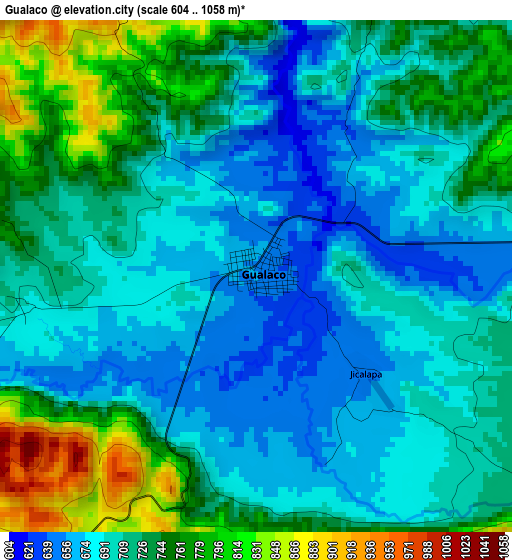
Below is the Elevation map of Gualaco, which displays elevation range with different colors. Scale of the first map is from 604 to 1058 m (1982 to 3471 ft) with average elevation of 715.7 meters (=2348 ft) [note 1]
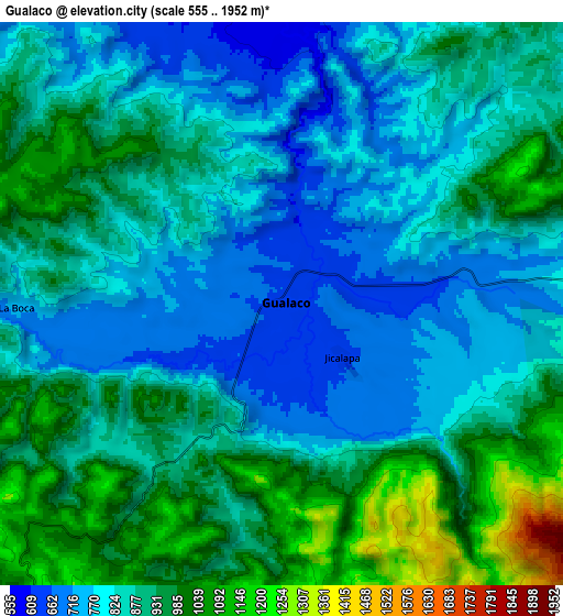
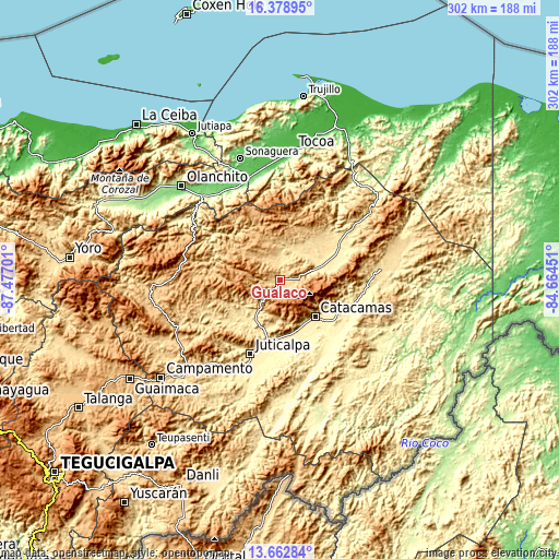
These maps also provides idea of topography and contour of this city, they are displayed at different zoom levels. More info about maps, scale and edge coordinates you can find below images.
| \ | Map #1 | Map #2 | Topo.Map |
| Scale [m] | 604..1058 m | 555..1952 m | × |
| Scale [ft] | 1982..3471 ft | 1821..6404 ft | × |
| Average | 715.7 m = 2348 ft | 873.7 m = 2866 ft | × |
| Width | 9.44 km = 5.9 mi | 18.88 km = 11.7 mi | 302 km = 187.7 mi |
| Height | 9.44 km = 5.9 mi | 18.88 km = 11.7 mi | 302 km = 187.7 mi |
| ↑Max Latitude | 15.067649° | 15.110079° | 16.37895° |
| Latitude at center | 15.02521° | 15.02521° | 15.02521° |
| ↓Min Latitude | 14.982763° | 14.940307° | 13.66284° |
| ← Min Longitude | -86.114705° | -86.158651° | -87.47701° |
| Longitude center | -86.07076° | -86.07076° | -86.07076° |
| →Max Longitude | -86.026815° | -85.982869° | -84.66451° |
Nearby cities:
Cities around Gualaco sort by population:
• San Francisco de la Paz elevation 667 m
19.7 km,  224°
224°
• Santa María del Real 337 m
31.5 km,  155°
155°
• Jutiquile 363 m
34.3 km,  182°
182°
• San Esteban 447 m
38.4 km,  57°
57°
• Punuare 323 m
34.3 km, 160°
• Arimís 713 m
27.9 km, 164°
• La Estancia 1132 m
30.1 km,  275°
275°
• El Guayabito 747 m
21.7 km,  169°
169°
• Guarizama 647 m
30.7 km,  246°
246°
• La Guata 934 m
34.2 km, 280°
• Laguna Seca 363 m
36.3 km, 184°
• Manto 658 m
35.7 km, 250°
Multilingual:
 En español:
Gualaco elevación 653 m.
 En France:
Gualaco élévation 653 m.


Sources and notes:
- [note 1] Map square and city borders are not equal. Map elevation data is calculated only from area inside that square.
- [src 1] Elevation data from geonames database provided with same terms of usage.
- [src 2] The elevation map of Gualaco is generated using elevation data from NASA's 3 arcsec (90m) resolution SRTM data.
- [src 3] Base (background) map © OpenStreetMap contributors tiles are generated by Geofabrik and OpenTopoMap.
Copyright & License:
This Gualaco Elevation Map is licensed under CC BY-SA. You may reuse any part from this page, if you give a proper credit by linking to this URL:
 More info on terms of use page.