San Esteban elevation
San Esteban (Olancho), Honduras elevation is 447 meters and San Esteban elevation in feet is 1467 ft above sea level [src 1]. San Esteban is a populated place (feature code) with elevation that is 96 meters (315 ft) smaller than average city elevation in Honduras.
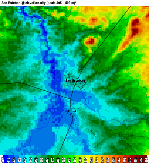
Below is the Elevation map of San Esteban, which displays elevation range with different colors. Scale of the first map is from 405 to 599 m (1329 to 1965 ft) with average elevation of 463 meters (=1519 ft) [note 1]
These maps also provides idea of topography and contour of this city, they are displayed at different zoom levels. More info about maps, scale and edge coordinates you can find below images.
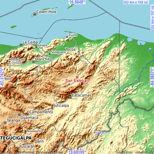
| \ | Map #1 | Topo.Map |
| Scale [m] | 405..599 m | × |
| Scale [ft] | 1329..1965 ft | × |
| Average | 463 m = 1519 ft | × |
| Width | 9.43 km = 5.9 mi | 301.7 km = 187.5 mi |
| Height | 9.43 km = 5.9 mi | 301.8 km = 187.5 mi |
| ↑Max Latitude | 15.254711° | 16.5648° |
| Latitude at center | 15.21231° | 15.21231° |
| ↓Min Latitude | 15.1699° | 13.85108° |
| ← Min Longitude | -85.813905° | -87.17621° |
| Longitude center | -85.76996° | -85.76996° |
| →Max Longitude | -85.726015° | -84.36371° |
Nearby cities:
Cities around San Esteban sort by population:
• San Francisco de la Paz elevation 667 m
57.8 km,  233°
233°
• Santa María del Real 337 m
53.2 km,  201°
201°
• Gualaco 653 m
38.4 km,  237°
237°
• Zamora 43 m
56.6 km,  325°
325°
• Dulce Nombre de Culmí 526 m
28.3 km,  116°
116°
• La Esperanza 442 m
46.8 km,  0°
0°
• Punuare 323 m
57.3 km, 201°
• Arimís 713 m
53.7 km,  207°
207°
• El Guayabito 747 m
50.8 km, 213°
• Taujica 36 m
56.5 km,  343°
343°
• Prieta 55 m
56.8 km,  316°
316°
• San José de Río Tinto 453 m
31.9 km,  166°
166°
Multilingual:
 En español:
San Esteban elevación 447 m.
 En France:
San Esteban élévation 447 m.
 Auf Deutsch:
San Esteban höhe über dem Meeresspiegel ist 447 m.

Sources and notes:
- [note 1] Map square and city borders are not equal. Map elevation data is calculated only from area inside that square.
- [src 1] Elevation data from geonames database provided with same terms of usage.
- [src 2] The elevation map of San Esteban is generated using elevation data from NASA's 3 arcsec (90m) resolution SRTM data.
- [src 3] Base (background) map © OpenStreetMap contributors tiles are generated by Geofabrik and OpenTopoMap.
Copyright & License:
This San Esteban Elevation Map is licensed under CC BY-SA. You may reuse any part from this page, if you give a proper credit by linking to this URL:
 More info on terms of use page.