San Francisco de la Paz elevation
San Francisco de la Paz (Olancho), Honduras elevation is 667 meters and San Francisco de la Paz elevation in feet is 2188 ft above sea level [src 1]. San Francisco de la Paz is a populated place (feature code) with elevation that is 124 meters (407 ft) bigger than average city elevation in Honduras.
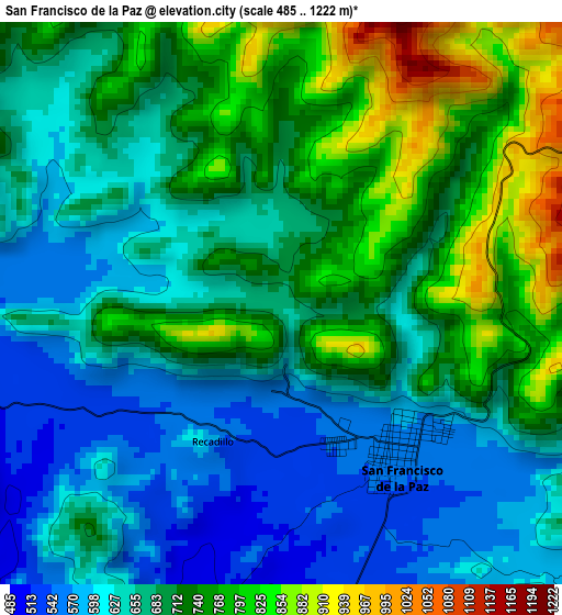
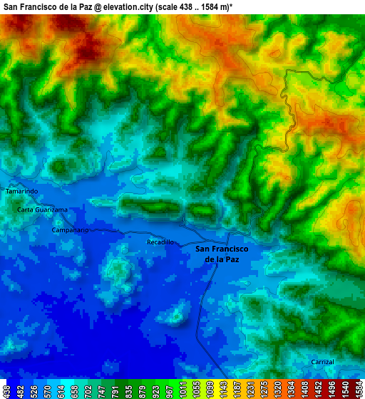
Below is the Elevation map of San Francisco de la Paz, which displays elevation range with different colors. Scale of the first map is from 485 to 1222 m (1591 to 4009 ft) with average elevation of 688.7 meters (=2260 ft) [note 1]
These maps also provides idea of topography and contour of this city, they are displayed at different zoom levels. More info about maps, scale and edge coordinates you can find below images.
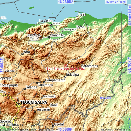
| \ | Map #1 | Map #2 | Topo.Map |
| Scale [m] | 485..1222 m | 438..1584 m | × |
| Scale [ft] | 1591..4009 ft | 1437..5197 ft | × |
| Average | 688.7 m = 2260 ft | 796.2 m = 2612 ft | × |
| Width | 9.44 km = 5.9 mi | 18.89 km = 11.7 mi | 302.2 km = 187.8 mi |
| Height | 9.44 km = 5.9 mi | 18.89 km = 11.7 mi | 302.2 km = 187.8 mi |
| ↑Max Latitude | 14.942464° | 14.984919° | 16.25456° |
| Latitude at center | 14.9° | 14.9° | 14.9° |
| ↓Min Latitude | 14.857528° | 14.815048° | 13.53686° |
| ← Min Longitude | -86.243945° | -86.287891° | -87.60625° |
| Longitude center | -86.2° | -86.2° | -86.2° |
| →Max Longitude | -86.156055° | -86.112109° | -84.79375° |
Nearby cities:
Cities around San Francisco de la Paz sort by population:
• Juticalpa elevation 391 m
26 km,  184°
184°
• Santa María del Real 337 m
30.7 km,  118°
118°
• Gualaco 653 m
19.7 km,  44°
44°
• Jutiquile 363 m
23.9 km,  148°
148°
• La Concepción 645 m
22.5 km,  189°
189°
• Arimís 713 m
25.1 km, 121°
• La Estancia 1132 m
23.2 km,  315°
315°
• El Guayabito 747 m
19.4 km,  112°
112°
• Guarizama 647 m
14.4 km,  277°
277°
• La Guata 934 m
28.3 km, 315°
• Laguna Seca 363 m
24.7 km, 154°
• Manto 658 m
19.8 km, 275°
Multilingual:
 En español:
San Francisco de la Paz elevación 667 m.
 En France:
San Francisco de la Paz élévation 667 m.
 Auf Deutsch:
San Francisco de la Paz höhe über dem Meeresspiegel ist 667 m.
 На русском:
San Francisco de la Paz высота над уровнем моря 667 м
Sources and notes:
- [note 1] Map square and city borders are not equal. Map elevation data is calculated only from area inside that square.
- [src 1] Elevation data from geonames database provided with same terms of usage.
- [src 2] The elevation map of San Francisco de la Paz is generated using elevation data from NASA's 3 arcsec (90m) resolution SRTM data.
- [src 3] Base (background) map © OpenStreetMap contributors tiles are generated by Geofabrik and OpenTopoMap.
Copyright & License:
This San Francisco de la Paz Elevation Map is licensed under CC BY-SA. You may reuse any part from this page, if you give a proper credit by linking to this URL:
 More info on terms of use page.