Jesús de Otoro elevation
Jesús de Otoro (Intibucá), Honduras elevation is 612 meters and Jesús de Otoro elevation in feet is 2008 ft above sea level [src 1]. Jesús de Otoro is a populated place (feature code) with elevation that is 69 meters (226 ft) bigger than average city elevation in Honduras.
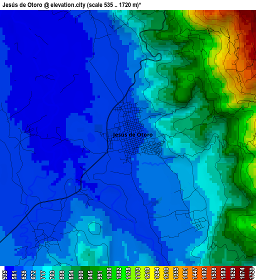
Below is the Elevation map of Jesús de Otoro, which displays elevation range with different colors. Scale of the first map is from 535 to 1720 m (1755 to 5643 ft) with average elevation of 736.7 meters (=2417 ft) [note 1]
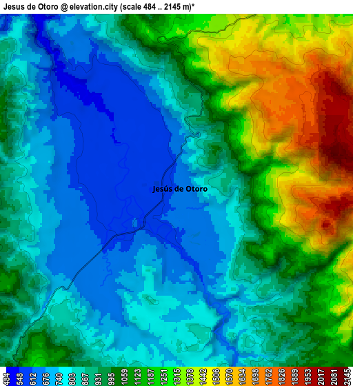
These maps also provides idea of topography and contour of this city, they are displayed at different zoom levels. More info about maps, scale and edge coordinates you can find below images.
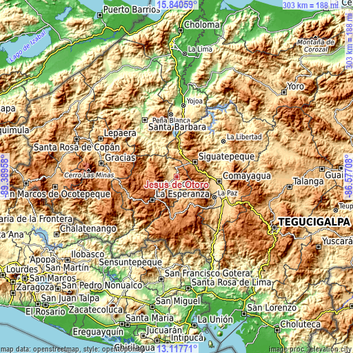
| \ | Map #1 | Map #2 | Topo.Map |
| Scale [m] | 535..1720 m | 484..2145 m | × |
| Scale [ft] | 1755..5643 ft | 1588..7037 ft | × |
| Average | 736.7 m = 2417 ft | 971.3 m = 3187 ft | × |
| Width | 9.46 km = 5.9 mi | 18.92 km = 11.8 mi | 302.8 km = 188.2 mi |
| Height | 9.46 km = 5.9 mi | 18.92 km = 11.8 mi | 302.8 km = 188.2 mi |
| ↑Max Latitude | 14.525875° | 14.568411° | 15.84059° |
| Latitude at center | 14.48333° | 14.48333° | 14.48333° |
| ↓Min Latitude | 14.440777° | 14.398216° | 13.11771° |
| ← Min Longitude | -88.027275° | -88.071221° | -89.38958° |
| Longitude center | -87.98333° | -87.98333° | -87.98333° |
| →Max Longitude | -87.939385° | -87.895439° | -86.57708° |
Nearby cities:
Cities around Jesús de Otoro sort by population:
• Siguatepeque elevation 1079 m
20.7 km,  51°
51°
• Intibucá 1692 m
27.1 km,  226°
226°
• Taulabé 571 m
24.2 km,  4°
4°
• Santiago Puringla 1036 m
17.3 km,  148°
148°
• El Rincón 1231 m
12.4 km,  25°
25°
• San José 1333 m
26.2 km,  172°
172°
• El Porvenir 1157 m
15.5 km,  44°
44°
• Potrerillos 1274 m
14.6 km,  59°
59°
• Ojos de Agua 1122 m
14 km,  22°
22°
• Aguas del Padre 1249 m
14.2 km, 49°
• El Socorro 1134 m
18.2 km, 23°
• San José de Comayagua 716 m
28.3 km,  349°
349°
Multilingual:
 En español:
Jesús de Otoro elevación 612 m.
 En France:
Jesús de Otoro élévation 612 m.
 Auf Deutsch:
Jesús de Otoro höhe über dem Meeresspiegel ist 612 m.

Sources and notes:
- [note 1] Map square and city borders are not equal. Map elevation data is calculated only from area inside that square.
- [src 1] Elevation data from geonames database provided with same terms of usage.
- [src 2] The elevation map of Jesús de Otoro is generated using elevation data from NASA's 3 arcsec (90m) resolution SRTM data.
- [src 3] Base (background) map © OpenStreetMap contributors tiles are generated by Geofabrik and OpenTopoMap.
Copyright & License:
This Jesús de Otoro Elevation Map is licensed under CC BY-SA. You may reuse any part from this page, if you give a proper credit by linking to this URL:
 More info on terms of use page.