La Ceiba elevation
La Ceiba (Atlántida), Honduras elevation is 14 meters and La Ceiba elevation in feet is 46 ft above sea level [src 1]. La Ceiba is a seat of a first-order administrative division (feature code) with elevation that is 529 meters (1736 ft) smaller than average city elevation in Honduras.
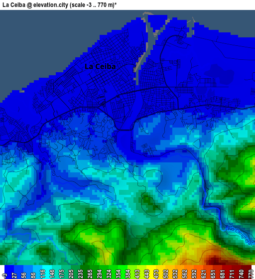
Below is the Elevation map of La Ceiba, which displays elevation range with different colors. Scale of the first map is from -3 to 770 m (-10 to 2526 ft) with average elevation of 110.4 meters (=362 ft) [note 1]
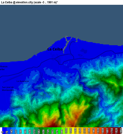
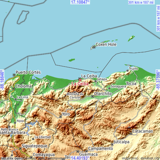
These maps also provides idea of topography and contour of this city, they are displayed at different zoom levels. More info about maps, scale and edge coordinates you can find below images.
| \ | Map #1 | Map #2 | Topo.Map |
| Scale [m] | -3..770 m | -3..1901 m | × |
| Scale [ft] | -10..2526 ft | -10..6237 ft | × |
| Average | 110.4 m = 362 ft | 332 m = 1089 ft | × |
| Width | 9.41 km = 5.8 mi | 18.81 km = 11.7 mi | 300.9 km = 187 mi |
| Height | 9.41 km = 5.8 mi | 18.81 km = 11.7 mi | 301 km = 187 mi |
| ↑Max Latitude | 15.801999° | 15.844279° | 17.10847° |
| Latitude at center | 15.75971° | 15.75971° | 15.75971° |
| ↓Min Latitude | 15.717412° | 15.675106° | 14.40193° |
| ← Min Longitude | -86.826155° | -86.870101° | -88.18846° |
| Longitude center | -86.78221° | -86.78221° | -86.78221° |
| →Max Longitude | -86.738265° | -86.694319° | -85.37596° |
Nearby cities:
Cities around La Ceiba sort by population:
• Olanchito elevation 158 m
38.1 km,  144°
144°
• La Masica 28 m
39.2 km,  246°
246°
• Santa Ana 25 m
32.8 km, 248°
• El Pino 32 m
17.5 km, 247°
• Jutiapa 12 m
28.4 km,  88°
88°
• San Francisco 27 m
31.2 km, 246°
• Sambo Creek 12 m
12.3 km,  59°
59°
• La Unión 3 m
23.8 km,  258°
258°
• El Porvenir 10 m
16.2 km,  266°
266°
• Corozal 8 m
8.3 km, 57°
• Nueva Armenia 9 m
30.6 km,  82°
82°
• Coyoles Central 199 m
41.9 km,  162°
162°
Multilingual:
 En español:
La Ceiba elevación 14 m.
 En France:
La Ceiba élévation 14 m.


Sources and notes:
- [note 1] Map square and city borders are not equal. Map elevation data is calculated only from area inside that square.
- [src 1] Elevation data from geonames database provided with same terms of usage.
- [src 2] The elevation map of La Ceiba is generated using elevation data from NASA's 3 arcsec (90m) resolution SRTM data.
- [src 3] Base (background) map © OpenStreetMap contributors tiles are generated by Geofabrik and OpenTopoMap.
Copyright & License:
This La Ceiba Elevation Map is licensed under CC BY-SA. You may reuse any part from this page, if you give a proper credit by linking to this URL:
 More info on terms of use page.