La Masica elevation
La Masica (Atlántida), Honduras elevation is 28 meters and La Masica elevation in feet is 92 ft above sea level [src 1]. La Masica is a populated place (feature code) with elevation that is 515 meters (1690 ft) smaller than average city elevation in Honduras.
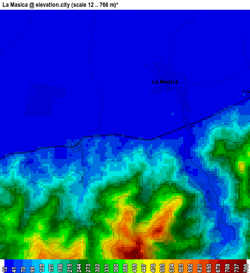
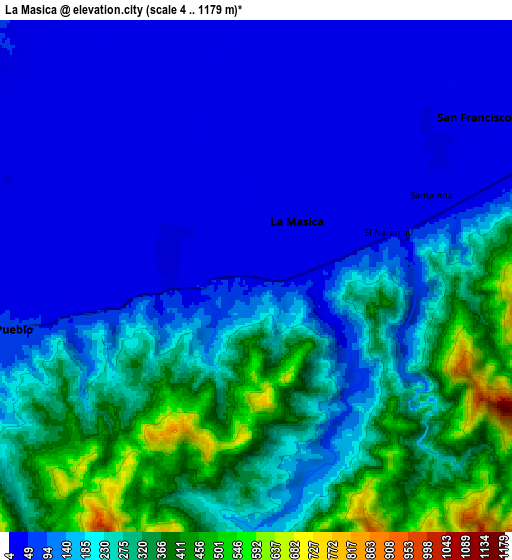
Below is the Elevation map of La Masica, which displays elevation range with different colors. Scale of the first map is from 12 to 766 m (39 to 2513 ft) with average elevation of 125 meters (=410 ft) [note 1]
These maps also provides idea of topography and contour of this city, they are displayed at different zoom levels. More info about maps, scale and edge coordinates you can find below images.
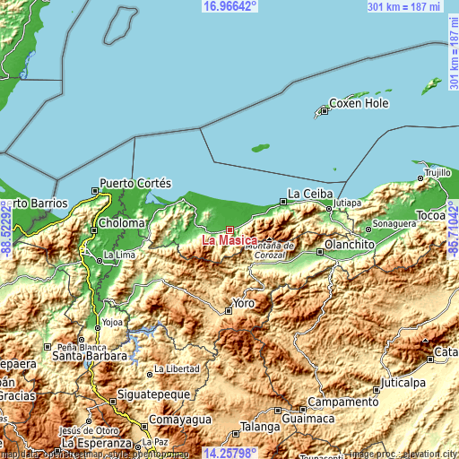
| \ | Map #1 | Map #2 | Topo.Map |
| Scale [m] | 12..766 m | 4..1179 m | × |
| Scale [ft] | 39..2513 ft | 13..3868 ft | × |
| Average | 125 m = 410 ft | 186.1 m = 611 ft | × |
| Width | 9.41 km = 5.8 mi | 18.82 km = 11.7 mi | 301.2 km = 187.2 mi |
| Height | 9.41 km = 5.8 mi | 18.82 km = 11.7 mi | 301.2 km = 187.2 mi |
| ↑Max Latitude | 15.658989° | 15.701299° | 16.96642° |
| Latitude at center | 15.61667° | 15.61667° | 15.61667° |
| ↓Min Latitude | 15.574343° | 15.532006° | 14.25798° |
| ← Min Longitude | -87.160615° | -87.204561° | -88.52292° |
| Longitude center | -87.11667° | -87.11667° | -87.11667° |
| →Max Longitude | -87.072725° | -87.028779° | -85.71042° |
Nearby cities:
Cities around La Masica sort by population:
• San Juan Pueblo elevation 171 m
13 km,  253°
253°
• Arizona 72 m
21.5 km,  274°
274°
• Santa Ana 25 m
6.5 km,  55°
55°
• El Pino 32 m
21.7 km, 64°
• San Francisco 27 m
8 km, 62°
• La Unión 3 m
16.7 km,  48°
48°
• El Porvenir 10 m
24.6 km, 52°
• San José 584 m
33.8 km,  189°
189°
• Atenas de San Cristóbal 21 m
22.7 km,  289°
289°
• San Antonio 577 m
31.7 km, 186°
• La Rosa 866 m
30.1 km,  169°
169°
• San Antonio 98 m
4 km,  242°
242°
Multilingual:
 En español:
La Masica elevación 28 m.
 En France:
La Masica élévation 28 m.
 Auf Deutsch:
La Masica höhe über dem Meeresspiegel ist 28 m.

Sources and notes:
- [note 1] Map square and city borders are not equal. Map elevation data is calculated only from area inside that square.
- [src 1] Elevation data from geonames database provided with same terms of usage.
- [src 2] The elevation map of La Masica is generated using elevation data from NASA's 3 arcsec (90m) resolution SRTM data.
- [src 3] Base (background) map © OpenStreetMap contributors tiles are generated by Geofabrik and OpenTopoMap.
Copyright & License:
This La Masica Elevation Map is licensed under CC BY-SA. You may reuse any part from this page, if you give a proper credit by linking to this URL:
 More info on terms of use page.