Olanchito elevation
Olanchito (Yoro), Honduras elevation is 158 meters and Olanchito elevation in feet is 518 ft above sea level [src 1]. Olanchito is a populated place (feature code) with elevation that is 385 meters (1263 ft) smaller than average city elevation in Honduras.
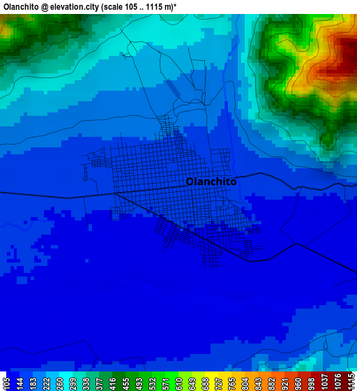
Below is the Elevation map of Olanchito, which displays elevation range with different colors. Scale of the first map is from 105 to 1115 m (344 to 3658 ft) with average elevation of 220.8 meters (=724 ft) [note 1]
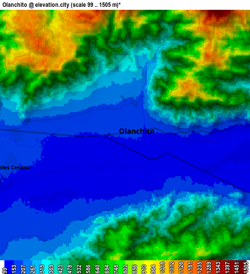
These maps also provides idea of topography and contour of this city, they are displayed at different zoom levels. More info about maps, scale and edge coordinates you can find below images.
| \ | Map #1 | Map #2 | Topo.Map |
| Scale [m] | 105..1115 m | 99..1505 m | × |
| Scale [ft] | 344..3658 ft | 325..4938 ft | × |
| Average | 220.8 m = 724 ft | 428.9 m = 1407 ft | × |
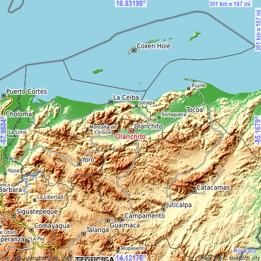
| Width | 9.42 km = 5.9 mi | 18.84 km = 11.7 mi | 301.3 km = 187.2 mi |
| Height | 9.42 km = 5.9 mi | 18.84 km = 11.7 mi | 301.4 km = 187.3 mi |
| ↑Max Latitude | 15.523657° | 15.565994° | 16.83198° |
| Latitude at center | 15.48131° | 15.48131° | 15.48131° |
| ↓Min Latitude | 15.438955° | 15.396591° | 14.12176° |
| ← Min Longitude | -86.618095° | -86.662041° | -87.9804° |
| Longitude center | -86.57415° | -86.57415° | -86.57415° |
| →Max Longitude | -86.530205° | -86.486259° | -85.1679° |
Nearby cities:
Cities around Olanchito sort by population:
• Elíxir elevation 90 m
29.4 km,  89°
89°
• El Ocote 581 m
7.2 km,  173°
173°
• Arenal 642 m
31.4 km,  242°
242°
• Tepusteca 456 m
28.5 km,  104°
104°
• Armenia 108 m
22.3 km, 94°
• Bálsamo Oriental 88 m
25.8 km, 89°
• El Juncal 135 m
15.5 km, 102°
• Nombre de Jesús 473 m
18.7 km,  218°
218°
• Coyoles Central 199 m
13.4 km,  227°
227°
• Teguajinal 904 m
13 km,  192°
192°
• Carbajales 378 m
24.3 km,  80°
80°
• Trojas 321 m
19.9 km, 222°
Multilingual:
 En español:
Olanchito elevación 158 m.
 En France:
Olanchito élévation 158 m.
 Auf Deutsch:
Olanchito höhe über dem Meeresspiegel ist 158 m.

Sources and notes:
- [note 1] Map square and city borders are not equal. Map elevation data is calculated only from area inside that square.
- [src 1] Elevation data from geonames database provided with same terms of usage.
- [src 2] The elevation map of Olanchito is generated using elevation data from NASA's 3 arcsec (90m) resolution SRTM data.
- [src 3] Base (background) map © OpenStreetMap contributors tiles are generated by Geofabrik and OpenTopoMap.
Copyright & License:
This Olanchito Elevation Map is licensed under CC BY-SA. You may reuse any part from this page, if you give a proper credit by linking to this URL:
 More info on terms of use page.