Río Chiquito elevation
Río Chiquito (Cortés), Honduras elevation is 24 meters and Río Chiquito elevation in feet is 79 ft above sea level [src 1]. Río Chiquito is a populated place (feature code) with elevation that is 519 meters (1703 ft) smaller than average city elevation in Honduras.
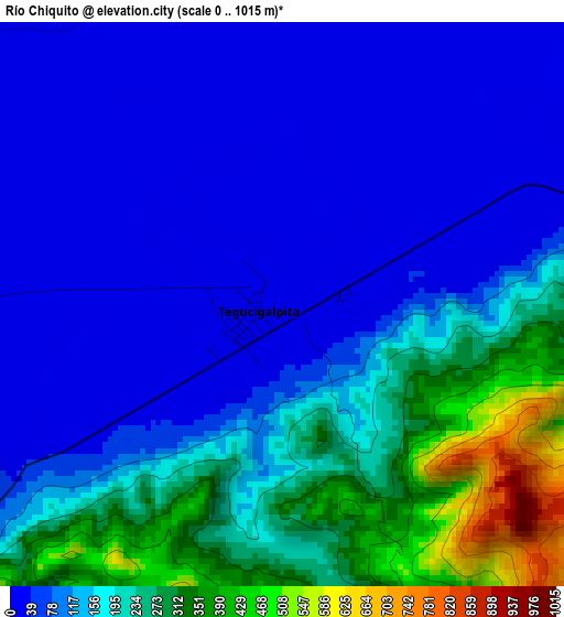
Below is the Elevation map of Río Chiquito, which displays elevation range with different colors. Scale of the first map is from 0 to 1015 m (0 to 3330 ft) with average elevation of 143.5 meters (=471 ft) [note 1]
These maps also provides idea of topography and contour of this city, they are displayed at different zoom levels. More info about maps, scale and edge coordinates you can find below images.
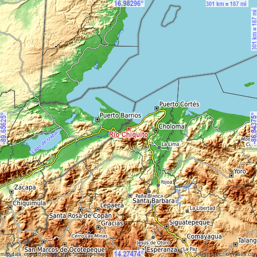
| \ | Map #1 | Topo.Map |
| Scale [m] | 0..1015 m | × |
| Scale [ft] | 0..3330 ft | × |
| Average | 143.5 m = 471 ft | × |
| Width | 9.41 km = 5.8 mi | 301.1 km = 187.1 mi |
| Height | 9.41 km = 5.8 mi | 301.1 km = 187.1 mi |
| ↑Max Latitude | 15.675645° | 16.98296° |
| Latitude at center | 15.63333° | 15.63333° |
| ↓Min Latitude | 15.591006° | 14.27474° |
| ← Min Longitude | -88.293945° | -89.65625° |
| Longitude center | -88.25° | -88.25° |
| →Max Longitude | -88.206055° | -86.84375° |
Nearby cities:
Cities around Río Chiquito sort by population:
• San Pedro Sula elevation 92 m
28.1 km,  120°
120°
• Cofradía 111 m
28.1 km,  157°
157°
• Cuyamel 17 m
6.5 km,  55°
55°
• Omoa 54 m
27.5 km, 57°
• La Jutosa 156 m
26.8 km,  90°
90°
• Naco 144 m
28.7 km,  165°
165°
• Peña Blanca 256 m
24.1 km, 117°
• Armenta 191 m
26.1 km, 124°
• El Zapotal del Norte 179 m
25 km, 121°
• Santa Elena 89 m
30.5 km, 155°
• Potrerillos 8 m
5.4 km,  270°
270°
• Chivana 222 m
31.4 km,  65°
65°
Multilingual:
 En español:
Río Chiquito elevación 24 m.
 En France:
Río Chiquito élévation 24 m.
 Auf Deutsch:
Río Chiquito höhe über dem Meeresspiegel ist 24 m.

Sources and notes:
- [note 1] Map square and city borders are not equal. Map elevation data is calculated only from area inside that square.
- [src 1] Elevation data from geonames database provided with same terms of usage.
- [src 2] The elevation map of Río Chiquito is generated using elevation data from NASA's 3 arcsec (90m) resolution SRTM data.
- [src 3] Base (background) map © OpenStreetMap contributors tiles are generated by Geofabrik and OpenTopoMap.
Copyright & License:
This Río Chiquito Elevation Map is licensed under CC BY-SA. You may reuse any part from this page, if you give a proper credit by linking to this URL:
 More info on terms of use page.