Naco elevation
Naco (Santa Bárbara), Honduras elevation is 144 meters and Naco elevation in feet is 472 ft above sea level [src 1]. Naco is a populated place (feature code) with elevation that is 399 meters (1309 ft) smaller than average city elevation in Honduras.
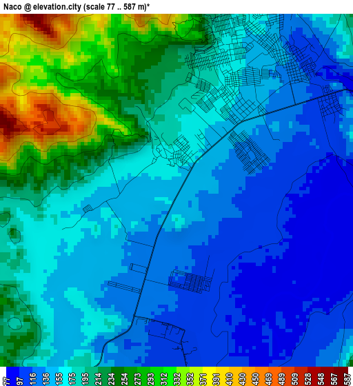
Below is the Elevation map of Naco, which displays elevation range with different colors. Scale of the first map is from 77 to 587 m (253 to 1926 ft) with average elevation of 178.4 meters (=585 ft) [note 1]
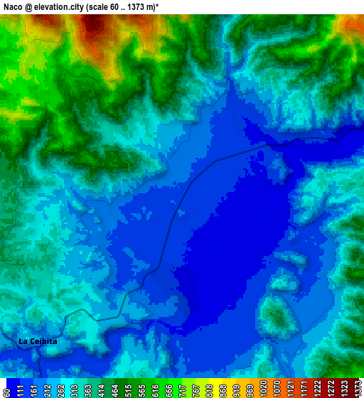
These maps also provides idea of topography and contour of this city, they are displayed at different zoom levels. More info about maps, scale and edge coordinates you can find below images.
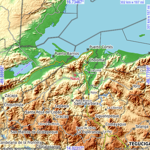
| \ | Map #1 | Map #2 | Topo.Map |
| Scale [m] | 77..587 m | 60..1373 m | × |
| Scale [ft] | 253..1926 ft | 197..4505 ft | × |
| Average | 178.4 m = 585 ft | 321.7 m = 1055 ft | × |
| Width | 9.42 km = 5.9 mi | 18.84 km = 11.7 mi | 301.5 km = 187.3 mi |
| Height | 9.42 km = 5.9 mi | 18.84 km = 11.7 mi | 301.5 km = 187.3 mi |
| ↑Max Latitude | 15.425697° | 15.468054° | 16.73467° |
| Latitude at center | 15.38333° | 15.38333° | 15.38333° |
| ↓Min Latitude | 15.340955° | 15.298571° | 14.02317° |
| ← Min Longitude | -88.227275° | -88.271221° | -89.58958° |
| Longitude center | -88.18333° | -88.18333° | -88.18333° |
| →Max Longitude | -88.139385° | -88.095439° | -86.77708° |
Nearby cities:
Cities around Naco sort by population:
• San Pedro Sula elevation 92 m
21.6 km,  51°
51°
• Villanueva 151 m
21 km,  110°
110°
• Cofradía 111 m
4 km,  62°
62°
• Pueblo Nuevo 116 m
21 km,  121°
121°
• Armenta 191 m
19.3 km, 47°
• El Zapotal del Norte 179 m
20.6 km,  43°
43°
• Nuevo Chamelecón 361 m
17.9 km,  90°
90°
• El Marañón 140 m
14.4 km,  82°
82°
• Laguna Verde 848 m
20.5 km,  174°
174°
• Santa Elena 89 m
5.4 km, 90°
• Camalote 201 m
17 km,  250°
250°
• Petoa 270 m
16.8 km,  219°
219°
Multilingual:
 En español:
Naco elevación 144 m.
 En France:
Naco élévation 144 m.


Sources and notes:
- [note 1] Map square and city borders are not equal. Map elevation data is calculated only from area inside that square.
- [src 1] Elevation data from geonames database provided with same terms of usage.
- [src 2] The elevation map of Naco is generated using elevation data from NASA's 3 arcsec (90m) resolution SRTM data.
- [src 3] Base (background) map © OpenStreetMap contributors tiles are generated by Geofabrik and OpenTopoMap.
Copyright & License:
This Naco Elevation Map is licensed under CC BY-SA. You may reuse any part from this page, if you give a proper credit by linking to this URL:
 More info on terms of use page.