Salamá elevation
Salamá (Olancho), Honduras elevation is 670 meters and Salamá elevation in feet is 2198 ft above sea level [src 1]. Salamá is a populated place (feature code) with elevation that is 127 meters (417 ft) bigger than average city elevation in Honduras.
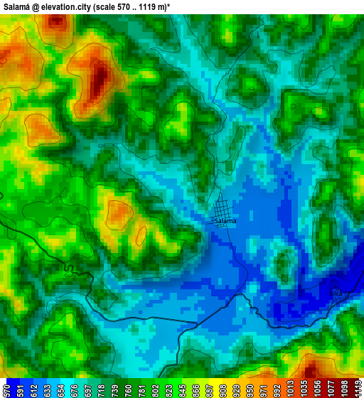
Below is the Elevation map of Salamá, which displays elevation range with different colors. Scale of the first map is from 570 to 1119 m (1870 to 3671 ft) with average elevation of 745.9 meters (=2447 ft) [note 1]
These maps also provides idea of topography and contour of this city, they are displayed at different zoom levels. More info about maps, scale and edge coordinates you can find below images.
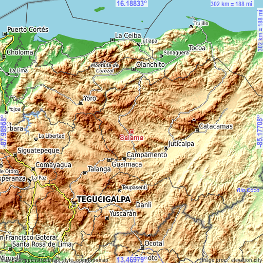
| \ | Map #1 | Topo.Map |
| Scale [m] | 570..1119 m | × |
| Scale [ft] | 1870..3671 ft | × |
| Average | 745.9 m = 2447 ft | × |
| Width | 9.45 km = 5.9 mi | 302.3 km = 187.8 mi |
| Height | 9.45 km = 5.9 mi | 302.3 km = 187.8 mi |
| ↑Max Latitude | 14.875807° | 16.18833° |
| Latitude at center | 14.83333° | 14.83333° |
| ↓Min Latitude | 14.790845° | 13.46979° |
| ← Min Longitude | -86.627275° | -87.98958° |
| Longitude center | -86.58333° | -86.58333° |
| →Max Longitude | -86.539385° | -85.17708° |
Nearby cities:
Cities around Salamá sort by population:
• Guaimaca elevation 884 m
41.7 km,  216°
216°
• Campamento 713 m
32.3 km,  192°
192°
• San Francisco de la Paz 667 m
41.9 km,  79°
79°
• La Concepción 645 m
40.4 km,  111°
111°
• Guayape 925 m
29.8 km,  244°
244°
• La Estancia 1132 m
34.8 km,  46°
46°
• Guarizama 647 m
28.4 km,  70°
70°
• Concordia 712 m
25.1 km,  196°
196°
• Mangulile 1099 m
34.9 km,  318°
318°
• La Guata 934 m
35.1 km,  37°
37°
• Silca 790 m
5.4 km,  90°
90°
• Manto 658 m
23.4 km, 66°
Multilingual:
 En español:
Salamá elevación 670 m.
 En France:
Salamá élévation 670 m.


Sources and notes:
- [note 1] Map square and city borders are not equal. Map elevation data is calculated only from area inside that square.
- [src 1] Elevation data from geonames database provided with same terms of usage.
- [src 2] The elevation map of Salamá is generated using elevation data from NASA's 3 arcsec (90m) resolution SRTM data.
- [src 3] Base (background) map © OpenStreetMap contributors tiles are generated by Geofabrik and OpenTopoMap.
Copyright & License:
This Salamá Elevation Map is licensed under CC BY-SA. You may reuse any part from this page, if you give a proper credit by linking to this URL:
 More info on terms of use page.