Sabá elevation
Sabá (Colón), Honduras elevation is 390 meters and Sabá elevation in feet is 1280 ft above sea level [src 1]. Sabá is a populated place (feature code) with elevation that is 153 meters (502 ft) smaller than average city elevation in Honduras.
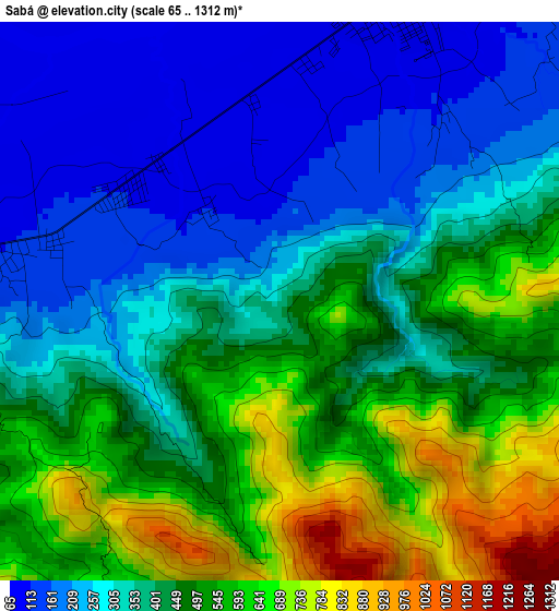
Below is the Elevation map of Sabá, which displays elevation range with different colors. Scale of the first map is from 65 to 1312 m (213 to 4304 ft) with average elevation of 408.1 meters (=1339 ft) [note 1]
These maps also provides idea of topography and contour of this city, they are displayed at different zoom levels. More info about maps, scale and edge coordinates you can find below images.
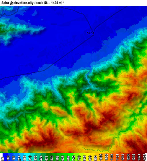
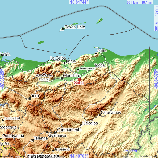
| \ | Map #1 | Map #2 | Topo.Map |
| Scale [m] | 65..1312 m | 56..1424 m | × |
| Scale [ft] | 213..4304 ft | 184..4672 ft | × |
| Average | 408.1 m = 1339 ft | 494 m = 1621 ft | × |
| Width | 9.42 km = 5.9 mi | 18.84 km = 11.7 mi | 301.4 km = 187.3 mi |
| Height | 9.42 km = 5.9 mi | 18.84 km = 11.7 mi | 301.4 km = 187.3 mi |
| ↑Max Latitude | 15.50902° | 15.55136° | 16.81744° |
| Latitude at center | 15.46667° | 15.46667° | 15.46667° |
| ↓Min Latitude | 15.424312° | 15.381945° | 14.10703° |
| ← Min Longitude | -86.293945° | -86.337891° | -87.65625° |
| Longitude center | -86.25° | -86.25° | -86.25° |
| →Max Longitude | -86.206055° | -86.162109° | -84.84375° |
Nearby cities:
Cities around Sabá sort by population:
• Tocoa elevation 37 m
36 km,  48°
48°
• Olanchito 158 m
34.8 km,  272°
272°
• Elíxir 90 m
5.7 km,  289°
289°
• Zamora 43 m
27 km, 46°
• El Ocote 581 m
34.4 km,  260°
260°
• Tepusteca 456 m
9.1 km,  232°
232°
• Armenia 108 m
12.5 km, 270°
• Bálsamo Oriental 88 m
9.1 km,  281°
281°
• El Juncal 135 m
19.7 km, 264°
• Teguajinal 904 m
39.1 km,  253°
253°
• Prieta 55 m
17.5 km,  43°
43°
• Carbajales 378 m
12.1 km,  297°
297°
Multilingual:
 En español:
Sabá elevación 390 m.
 En France:
Sabá élévation 390 m.


Sources and notes:
- [note 1] Map square and city borders are not equal. Map elevation data is calculated only from area inside that square.
- [src 1] Elevation data from geonames database provided with same terms of usage.
- [src 2] The elevation map of Sabá is generated using elevation data from NASA's 3 arcsec (90m) resolution SRTM data.
- [src 3] Base (background) map © OpenStreetMap contributors tiles are generated by Geofabrik and OpenTopoMap.
Copyright & License:
This Sabá Elevation Map is licensed under CC BY-SA. You may reuse any part from this page, if you give a proper credit by linking to this URL:
 More info on terms of use page.