Tocoa elevation
Tocoa (Colón), Honduras elevation is 37 meters and Tocoa elevation in feet is 121 ft above sea level [src 1]. Tocoa is a populated place (feature code) with elevation that is 506 meters (1660 ft) smaller than average city elevation in Honduras.
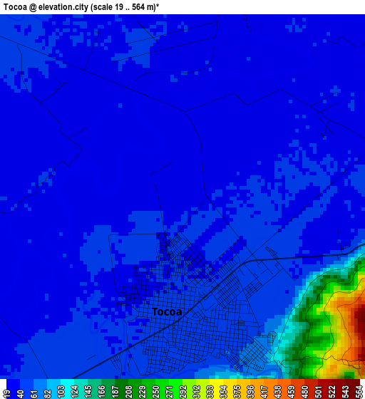
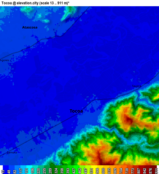
Below is the Elevation map of Tocoa, which displays elevation range with different colors. Scale of the first map is from 19 to 564 m (62 to 1850 ft) with average elevation of 54.3 meters (=178 ft) [note 1]
These maps also provides idea of topography and contour of this city, they are displayed at different zoom levels. More info about maps, scale and edge coordinates you can find below images.
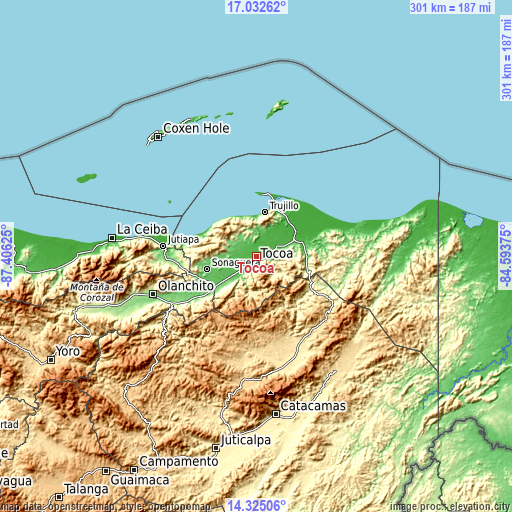
| \ | Map #1 | Map #2 | Topo.Map |
| Scale [m] | 19..564 m | 13..911 m | × |
| Scale [ft] | 62..1850 ft | 43..2989 ft | × |
| Average | 54.3 m = 178 ft | 120.9 m = 397 ft | × |
| Width | 9.41 km = 5.8 mi | 18.82 km = 11.7 mi | 301.1 km = 187.1 mi |
| Height | 9.41 km = 5.8 mi | 18.82 km = 11.7 mi | 301.1 km = 187.1 mi |
| ↑Max Latitude | 15.725635° | 15.767931° | 17.03262° |
| Latitude at center | 15.68333° | 15.68333° | 15.68333° |
| ↓Min Latitude | 15.641016° | 15.598694° | 14.32506° |
| ← Min Longitude | -86.043945° | -86.087891° | -87.40625° |
| Longitude center | -86° | -86° | -86° |
| →Max Longitude | -85.956055° | -85.912109° | -84.59375° |
Nearby cities:
Cities around Tocoa sort by population:
• Sabá elevation 390 m
36 km,  228°
228°
• Trujillo 35 m
26.4 km,  10°
10°
• Bonito Oriental 32 m
29.2 km,  75°
75°
• Zamora 43 m
9 km, 232°
• Corocito 50 m
24.3 km,  72°
72°
• Quebrada de Arena 31 m
12.9 km,  43°
43°
• Jericó 10 m
29.9 km, 6°
• La Esperanza 442 m
25.6 km,  102°
102°
• Salamá 25 m
8.2 km,  25°
25°
• Taujica 36 m
9.1 km, 78°
• Prieta 55 m
18.6 km, 232°
• La Brea 45 m
13.5 km,  15°
15°
Multilingual:
 En español:
Tocoa elevación 37 m.
 En France:
Tocoa élévation 37 m.


Sources and notes:
- [note 1] Map square and city borders are not equal. Map elevation data is calculated only from area inside that square.
- [src 1] Elevation data from geonames database provided with same terms of usage.
- [src 2] The elevation map of Tocoa is generated using elevation data from NASA's 3 arcsec (90m) resolution SRTM data.
- [src 3] Base (background) map © OpenStreetMap contributors tiles are generated by Geofabrik and OpenTopoMap.
Copyright & License:
This Tocoa Elevation Map is licensed under CC BY-SA. You may reuse any part from this page, if you give a proper credit by linking to this URL:
 More info on terms of use page.