Bonito Oriental elevation
Bonito Oriental (Colón), Honduras elevation is 32 meters and Bonito Oriental elevation in feet is 105 ft above sea level [src 1]. Bonito Oriental is a populated place (feature code) with elevation that is 511 meters (1677 ft) smaller than average city elevation in Honduras.
Below is the Elevation map of Bonito Oriental, which displays elevation range with different colors. Scale of the first map is from 8 to 536 m (26 to 1759 ft) with average elevation of 80.8 meters (=265 ft) [note 1]
These maps also provides idea of topography and contour of this city, they are displayed at different zoom levels. More info about maps, scale and edge coordinates you can find below images.
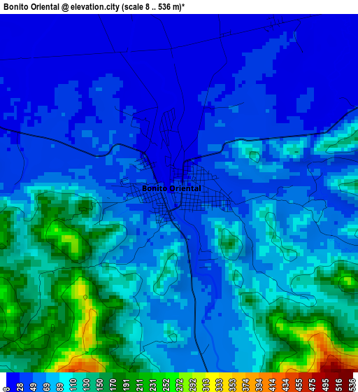
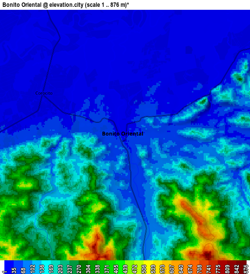
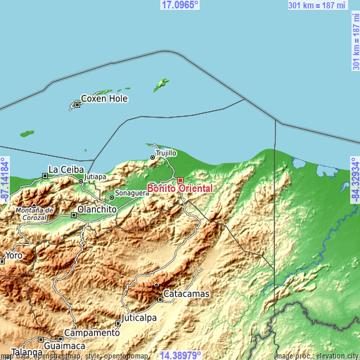
| \ | Map #1 | Map #2 | Topo.Map |
| Scale [m] | 8..536 m | 1..876 m | × |
| Scale [ft] | 26..1759 ft | 3..2874 ft | × |
| Average | 80.8 m = 265 ft | 130.2 m = 427 ft | × |
| Width | 9.41 km = 5.8 mi | 18.81 km = 11.7 mi | 301 km = 187 mi |
| Height | 9.41 km = 5.8 mi | 18.81 km = 11.7 mi | 301 km = 187 mi |
| ↑Max Latitude | 15.789941° | 15.832224° | 17.0965° |
| Latitude at center | 15.74765° | 15.74765° | 15.74765° |
| ↓Min Latitude | 15.70535° | 15.663041° | 14.38979° |
| ← Min Longitude | -85.779535° | -85.823481° | -87.14184° |
| Longitude center | -85.73559° | -85.73559° | -85.73559° |
| →Max Longitude | -85.691645° | -85.647699° | -84.32934° |
Nearby cities:
Cities around Bonito Oriental sort by population:
• Tocoa elevation 37 m
29.2 km,  255°
255°
• Trujillo 35 m
30 km,  308°
308°
• Zamora 43 m
37.7 km,  250°
250°
• Corocito 50 m
5.1 km,  272°
272°
• Quebrada de Arena 31 m
19.5 km,  276°
276°
• Jericó 10 m
33.4 km, 312°
• La Esperanza 442 m
13.1 km,  194°
194°
• Salamá 25 m
24.7 km, 270°
• Francia 4 m
19.9 km,  55°
55°
• Santa Rosa de Aguán 3 m
22.6 km,  5°
5°
• Taujica 36 m
20.1 km, 254°
• La Brea 45 m
25.4 km, 283°
Multilingual:
 En español:
Bonito Oriental elevación 32 m.
 En France:
Bonito Oriental élévation 32 m.
 Auf Deutsch:
Bonito Oriental höhe über dem Meeresspiegel ist 32 m.

Sources and notes:
- [note 1] Map square and city borders are not equal. Map elevation data is calculated only from area inside that square.
- [src 1] Elevation data from geonames database provided with same terms of usage.
- [src 2] The elevation map of Bonito Oriental is generated using elevation data from NASA's 3 arcsec (90m) resolution SRTM data.
- [src 3] Base (background) map © OpenStreetMap contributors tiles are generated by Geofabrik and OpenTopoMap.
Copyright & License:
This Bonito Oriental Elevation Map is licensed under CC BY-SA. You may reuse any part from this page, if you give a proper credit by linking to this URL:
 More info on terms of use page.