Zunil elevation
Zunil (Quetzaltenango), Guatemala elevation is 2200 meters and Zunil elevation in feet is 7218 ft above sea level [src 1]. Zunil is a seat of a second-order administrative division (feature code) with elevation that is 933 meters (3061 ft) bigger than average city elevation in Guatemala.
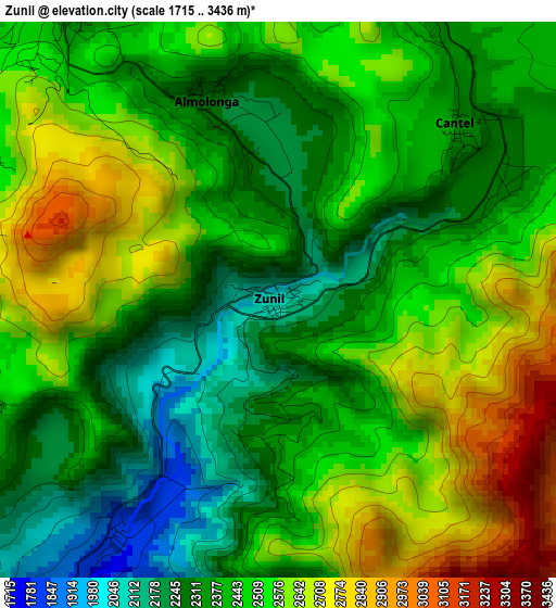
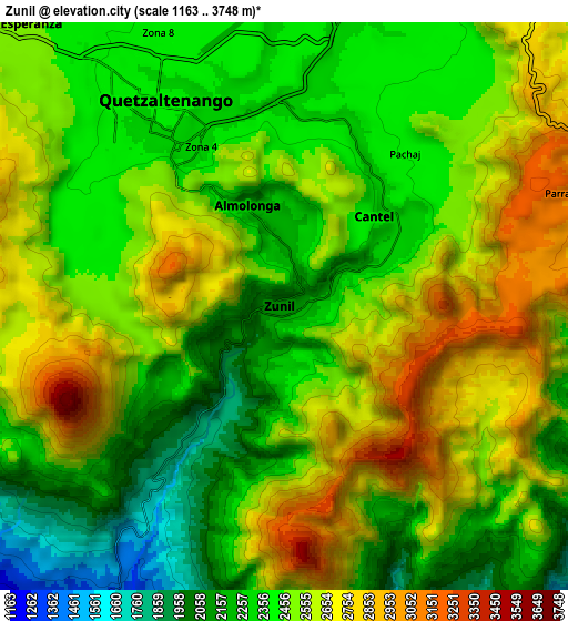
Below is the Elevation map of Zunil, which displays elevation range with different colors. Scale of the first map is from 1715 to 3436 m (5627 to 11273 ft) with average elevation of 2473.9 meters (=8116 ft) [note 1]
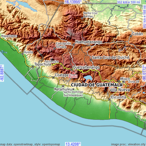
These maps also provides idea of topography and contour of this city, they are displayed at different zoom levels. More info about maps, scale and edge coordinates you can find below images.
| \ | Map #1 | Map #2 | Topo.Map |
| Scale [m] | 1715..3436 m | 1163..3748 m | × |
| Scale [ft] | 5627..11273 ft | 3816..12297 ft | × |
| Average | 2473.9 m = 8116 ft | 2487.5 m = 8161 ft | × |
| Width | 9.45 km = 5.9 mi | 18.9 km = 11.7 mi | 302.3 km = 187.8 mi |
| Height | 9.45 km = 5.9 mi | 18.9 km = 11.7 mi | 302.4 km = 187.9 mi |
| ↑Max Latitude | 14.827116° | 14.869594° | 16.13995° |
| Latitude at center | 14.78463° | 14.78463° | 14.78463° |
| ↓Min Latitude | 14.742135° | 14.699633° | 13.4208° |
| ← Min Longitude | -91.527395° | -91.571341° | -92.8897° |
| Longitude center | -91.48345° | -91.48345° | -91.48345° |
| →Max Longitude | -91.439505° | -91.395559° | -90.0772° |
Nearby cities:
Cities around Zunil sort by population:
• Quetzaltenango elevation 2344 m
6.7 km,  326°
326°
• Cantel 2296 m
4.3 km,  45°
45°
• La Esperanza 2455 m
12.8 km,  319°
319°
• Santa Catarina Ixtahuacán 2198 m
13.5 km,  83°
83°
• San Andrés Xecul 2420 m
13.4 km,  0°
0°
• Salcajá 2349 m
10.9 km,  15°
15°
• Almolonga 2322 m
3.7 km,  340°
340°
• San Mateo 2576 m
14.1 km,  305°
305°
• San Cristóbal Totonicapán 2397 m
15.4 km, 17°
• Pueblo Nuevo 974 m
16.4 km,  201°
201°
• San Francisco la Unión 2749 m
16.7 km, 337°
• Olintepeque 2384 m
11.8 km, 343°
Multilingual:
 En español:
Zunil elevación 2200 m.
 En France:
Zunil élévation 2200 m.


Sources and notes:
- [note 1] Map square and city borders are not equal. Map elevation data is calculated only from area inside that square.
- [src 1] Elevation data from geonames database provided with same terms of usage.
- [src 2] The elevation map of Zunil is generated using elevation data from NASA's 3 arcsec (90m) resolution SRTM data.
- [src 3] Base (background) map © OpenStreetMap contributors tiles are generated by Geofabrik and OpenTopoMap.
Copyright & License:
This Zunil Elevation Map is licensed under CC BY-SA. You may reuse any part from this page, if you give a proper credit by linking to this URL:
 More info on terms of use page.