Santa Catarina Ixtahuacán elevation
Santa Catarina Ixtahuacán (Sololá), Guatemala elevation is 2198 meters and Santa Catarina Ixtahuacán elevation in feet is 7211 ft above sea level [src 1]. Santa Catarina Ixtahuacán is a seat of a second-order administrative division (feature code) with elevation that is 931 meters (3054 ft) bigger than average city elevation in Guatemala.
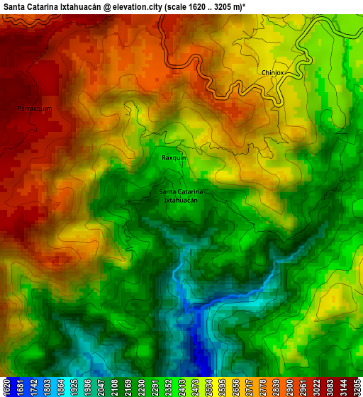
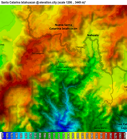
Below is the Elevation map of Santa Catarina Ixtahuacán, which displays elevation range with different colors. Scale of the first map is from 1620 to 3205 m (5315 to 10515 ft) with average elevation of 2483.2 meters (=8147 ft) [note 1]
These maps also provides idea of topography and contour of this city, they are displayed at different zoom levels. More info about maps, scale and edge coordinates you can find below images.
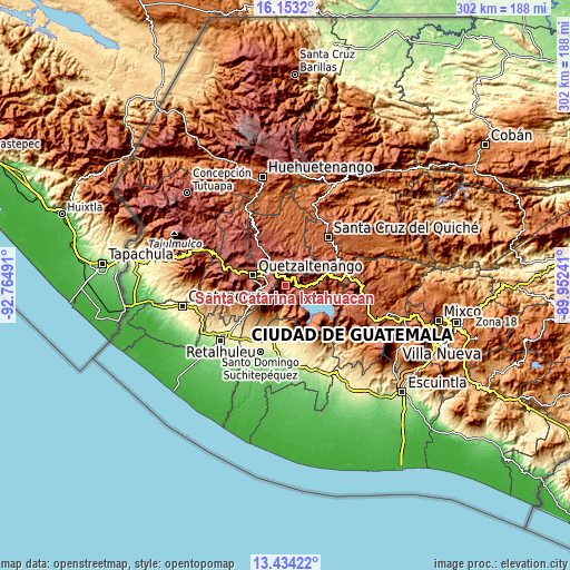
| \ | Map #1 | Map #2 | Topo.Map |
| Scale [m] | 1620..3205 m | 1206..3449 m | × |
| Scale [ft] | 5315..10515 ft | 3957..11316 ft | × |
| Average | 2483.2 m = 8147 ft | 2520.6 m = 8270 ft | × |
| Width | 9.45 km = 5.9 mi | 18.9 km = 11.7 mi | 302.3 km = 187.8 mi |
| Height | 9.45 km = 5.9 mi | 18.9 km = 11.7 mi | 302.3 km = 187.8 mi |
| ↑Max Latitude | 14.840454° | 14.882929° | 16.1532° |
| Latitude at center | 14.79797° | 14.79797° | 14.79797° |
| ↓Min Latitude | 14.755478° | 14.712978° | 13.43422° |
| ← Min Longitude | -91.402605° | -91.446551° | -92.76491° |
| Longitude center | -91.35866° | -91.35866° | -91.35866° |
| →Max Longitude | -91.314715° | -91.270769° | -89.95241° |
Nearby cities:
Cities around Santa Catarina Ixtahuacán sort by population:
• Totonicapán elevation 2499 m
12.6 km,  358°
358°
• Nahualá 2482 m
6.6 km,  41°
41°
• Cantel 2296 m
10.5 km,  278°
278°
• Salcajá 2349 m
13.9 km,  310°
310°
• Almolonga 2322 m
14.8 km, 277°
• Zunil 2200 m
13.5 km,  263°
263°
• San Pablo La Laguna 1621 m
12.6 km,  132°
132°
• Santa Clara La Laguna 2075 m
11 km,  147°
147°
• San Juan La Laguna 1578 m
13.9 km, 146°
• San Marcos La Laguna 1723 m
13.5 km, 126°
• Santa María Visitación 2010 m
10.5 km, 148°
• Santa Lucía Utatlán 2576 m
10.3 km,  106°
106°
Multilingual:
 En español:
Santa Catarina Ixtaguacán elevación 2198 m.
 En France:
Santa Catarina Ixtahuacán élévation 2198 m.
 Auf Deutsch:
Santa Catarina Ixtahuacán höhe über dem Meeresspiegel ist 2198 m.
 На русском:
Santa Catarina Ixtahuacán высота над уровнем моря 2198 м
Sources and notes:
- [note 1] Map square and city borders are not equal. Map elevation data is calculated only from area inside that square.
- [src 1] Elevation data from geonames database provided with same terms of usage.
- [src 2] The elevation map of Santa Catarina Ixtahuacán is generated using elevation data from NASA's 3 arcsec (90m) resolution SRTM data.
- [src 3] Base (background) map © OpenStreetMap contributors tiles are generated by Geofabrik and OpenTopoMap.
Copyright & License:
This Santa Catarina Ixtahuacán Elevation Map is licensed under CC BY-SA. You may reuse any part from this page, if you give a proper credit by linking to this URL:
 More info on terms of use page.