Spárti elevation
Spárti (Peloponnese, Nomós Lakonías), Greece elevation is 206 meters and Spárti elevation in feet is 676 ft above sea level [src 1]. Spárti is a seat of a second-order administrative division (feature code) with elevation that is 55 meters (180 ft) bigger than average city elevation in Greece.
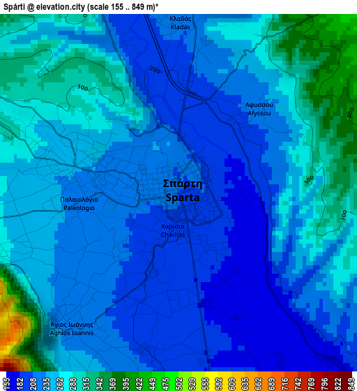
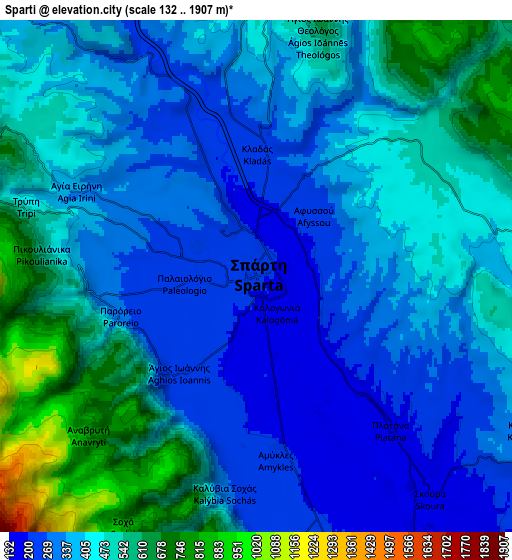
Below is the Elevation map of Spárti, which displays elevation range with different colors. Scale of the first map is from 155 to 849 m (509 to 2785 ft) with average elevation of 246.1 meters (=807 ft) [note 1]
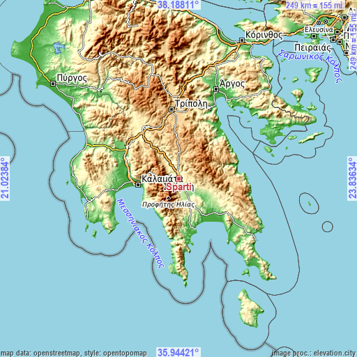
These maps also provides idea of topography and contour of this city, they are displayed at different zoom levels. More info about maps, scale and edge coordinates you can find below images.
| \ | Map #1 | Map #2 | Topo.Map |
| Scale [m] | 155..849 m | 132..1907 m | × |
| Scale [ft] | 509..2785 ft | 433..6257 ft | × |
| Average | 246.1 m = 807 ft | 413.1 m = 1355 ft | × |
| Width | 7.8 km = 4.8 mi | 15.59 km = 9.7 mi | 249.5 km = 155 mi |
| Height | 7.8 km = 4.8 mi | 15.59 km = 9.7 mi | 249.5 km = 155 mi |
| ↑Max Latitude | 37.109514° | 37.144551° | 38.18811° |
| Latitude at center | 37.07446° | 37.07446° | 37.07446° |
| ↓Min Latitude | 37.03939° | 37.004304° | 35.94421° |
| ← Min Longitude | 22.386145° | 22.342199° | 21.02384° |
| Longitude center | 22.43009° | 22.43009° | 22.43009° |
| →Max Longitude | 22.474035° | 22.517981° | 23.83634° |
Nearby cities:
Cities around Spárti sort by population:
• Kalamata elevation 26 m
28.4 km,  262°
262°
• Skála 14 m
32.6 km,  139°
139°
• Vlachiótis 29 m
34.3 km,  133°
133°
• Paralía Vérgas 26 m
25.4 km,  252°
252°
• Magoúla 239 m
2.3 km,  285°
285°
• Krokeés 309 m
23.7 km,  154°
154°
• Geráki 360 m
26.2 km,  110°
110°
• Thouría 25 m
33.8 km,  271°
271°
• Arfará 90 m
35.3 km,  284°
284°
• Karyés 894 m
24.9 km,  14°
14°
• Sperchógeia 54 m
32.6 km, 269°
• Kardamýli 15 m
27.1 km,  220°
220°
Multilingual:
 En español:
Esparta elevación 206 m.
 En France:
Sparte élévation 206 m.
 Auf Deutsch:
Lakedaimon höhe über dem Meeresspiegel ist 206 m.

Sources and notes:
- [note 1] Map square and city borders are not equal. Map elevation data is calculated only from area inside that square.
- [src 1] Elevation data from geonames database provided with same terms of usage.
- [src 2] The elevation map of Spárti is generated using elevation data from NASA's 3 arcsec (90m) resolution SRTM data.
- [src 3] Base (background) map © OpenStreetMap contributors tiles are generated by Geofabrik and OpenTopoMap.
Copyright & License:
This Spárti Elevation Map is licensed under CC BY-SA. You may reuse any part from this page, if you give a proper credit by linking to this URL:
 More info on terms of use page.