Skála elevation
Skála (Peloponnese, Nomós Lakonías), Greece elevation is 14 meters and Skála elevation in feet is 46 ft above sea level [src 1]. Skála is a seat of a third-order administrative division (feature code) with elevation that is 137 meters (449 ft) smaller than average city elevation in Greece.
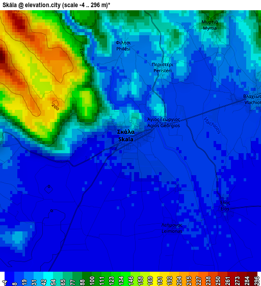
Below is the Elevation map of Skála, which displays elevation range with different colors. Scale of the first map is from -4 to 296 m (-13 to 971 ft) with average elevation of 41.4 meters (=136 ft) [note 1]
These maps also provides idea of topography and contour of this city, they are displayed at different zoom levels. More info about maps, scale and edge coordinates you can find below images.
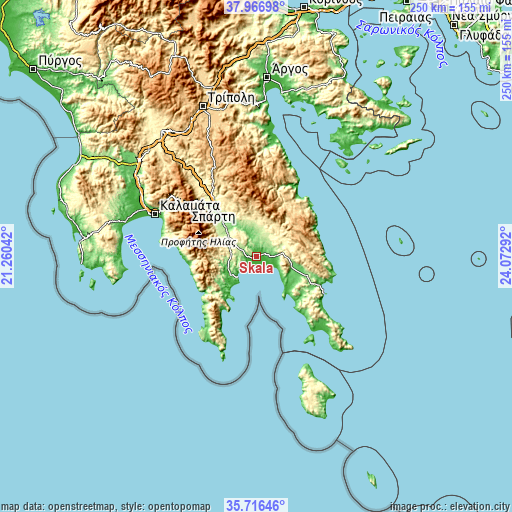
| \ | Map #1 | Topo.Map |
| Scale [m] | -4..296 m | × |
| Scale [ft] | -13..971 ft | × |
| Average | 41.4 m = 136 ft | × |
| Width | 7.82 km = 4.9 mi | 250.2 km = 155.5 mi |
| Height | 7.82 km = 4.9 mi | 250.2 km = 155.5 mi |
| ↑Max Latitude | 36.885157° | 37.96698° |
| Latitude at center | 36.85° | 36.85° |
| ↓Min Latitude | 36.814827° | 35.71646° |
| ← Min Longitude | 22.622725° | 21.26042° |
| Longitude center | 22.66667° | 22.66667° |
| →Max Longitude | 22.710615° | 24.07292° |
Nearby cities:
Cities around Skála sort by population:
• Spárti elevation 206 m
32.6 km,  319°
319°
• Gýtheio 168 m
14 km,  220°
220°
• Moláoi 208 m
17.1 km,  106°
106°
• Vlachiótis 29 m
3.9 km,  71°
71°
• Káto Glykóvrysi 39 m
10.1 km,  104°
104°
• Magoúla 239 m
34.6 km, 317°
• Krokeés 309 m
11.3 km,  288°
288°
• Geráki 360 m
16.2 km,  12°
12°
• Géfyra 21 m
37.5 km,  118°
118°
• Asopós 51 m
21.4 km,  128°
128°
• Sykiá 167 m
26.4 km, 111°
• Kardamýli 15 m
38.8 km,  276°
276°
Multilingual:
 En español:
Skála elevación 14 m.
 En France:
Skála élévation 14 m.


Sources and notes:
- [note 1] Map square and city borders are not equal. Map elevation data is calculated only from area inside that square.
- [src 1] Elevation data from geonames database provided with same terms of usage.
- [src 2] The elevation map of Skála is generated using elevation data from NASA's 3 arcsec (90m) resolution SRTM data.
- [src 3] Base (background) map © OpenStreetMap contributors tiles are generated by Geofabrik and OpenTopoMap.
Copyright & License:
This Skála Elevation Map is licensed under CC BY-SA. You may reuse any part from this page, if you give a proper credit by linking to this URL:
 More info on terms of use page.