Akim Swedru elevation
Akim Swedru (Eastern, Birim South), Ghana elevation is 140 meters and Akim Swedru elevation in feet is 459 ft above sea level [src 1]. Akim Swedru is a seat of a second-order administrative division (feature code) with elevation that is 30 meters (98 ft) smaller than average city elevation in Ghana.
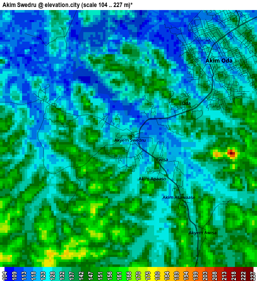
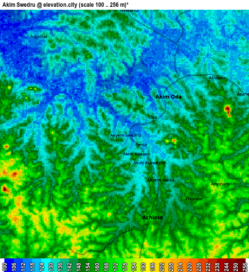
Below is the Elevation map of Akim Swedru, which displays elevation range with different colors. Scale of the first map is from 104 to 227 m (341 to 745 ft) with average elevation of 133.5 meters (=438 ft) [note 1]
These maps also provides idea of topography and contour of this city, they are displayed at different zoom levels. More info about maps, scale and edge coordinates you can find below images.
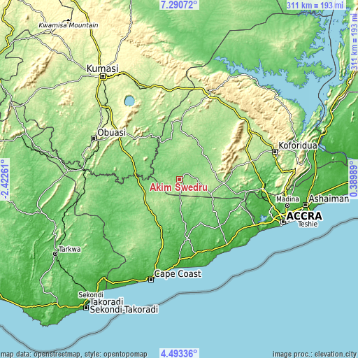
| \ | Map #1 | Map #2 | Topo.Map |
| Scale [m] | 104..227 m | 100..256 m | × |
| Scale [ft] | 341..745 ft | 328..840 ft | × |
| Average | 133.5 m = 438 ft | 143 m = 469 ft | × |
| Width | 9.72 km = 6 mi | 19.44 km = 12.1 mi | 311 km = 193.2 mi |
| Height | 9.72 km = 6 mi | 19.44 km = 12.1 mi | 311.1 km = 193.3 mi |
| ↑Max Latitude | 5.937511° | 5.981219° | 7.29072° |
| Latitude at center | 5.8938° | 5.8938° | 5.8938° |
| ↓Min Latitude | 5.850085° | 5.806367° | 4.49336° |
| ← Min Longitude | -1.060305° | -1.104251° | -2.42261° |
| Longitude center | -1.01636° | -1.01636° | -1.01636° |
| →Max Longitude | -0.972415° | -0.928469° | 0.38989° |
Nearby cities:
Cities around Akim Swedru sort by population:
• Akim Oda elevation 132 m
5 km,  42°
42°
• Swedru 74 m
52.9 km,  138°
138°
• Suhum 182 m
64.7 km,  75°
75°
• Nsawam 61 m
74.3 km,  97°
97°
• Winneba 25 m
74.4 km, 144°
• Asamankese 147 m
39.2 km, 95°
• Akwatia 138 m
28.1 km,  54°
54°
• Apam 12 m
74.4 km,  155°
155°
• Foso 148 m
36.8 km,  234°
234°
• Mumford 33 m
75.8 km, 157°
• Kibi 318 m
59.4 km,  59°
59°
• Odumase Krobo 214 m
74.5 km,  17°
17°
Multilingual:
 En español:
Akim Swedru elevación 140 m.
 En France:
Akim Swedru élévation 140 m.
 Auf Deutsch:
Akim Swedru höhe über dem Meeresspiegel ist 140 m.

Sources and notes:
- [note 1] Map square and city borders are not equal. Map elevation data is calculated only from area inside that square.
- [src 1] Elevation data from geonames database provided with same terms of usage.
- [src 2] The elevation map of Akim Swedru is generated using elevation data from NASA's 3 arcsec (90m) resolution SRTM data.
- [src 3] Base (background) map © OpenStreetMap contributors tiles are generated by Geofabrik and OpenTopoMap.
Copyright & License:
This Akim Swedru Elevation Map is licensed under CC BY-SA. You may reuse any part from this page, if you give a proper credit by linking to this URL:
 More info on terms of use page.