Akwatia elevation
Akwatia (Eastern), Ghana elevation is 138 meters and Akwatia elevation in feet is 453 ft above sea level [src 1]. Akwatia is a populated place (feature code) with elevation that is 32 meters (105 ft) smaller than average city elevation in Ghana.
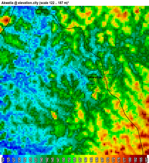
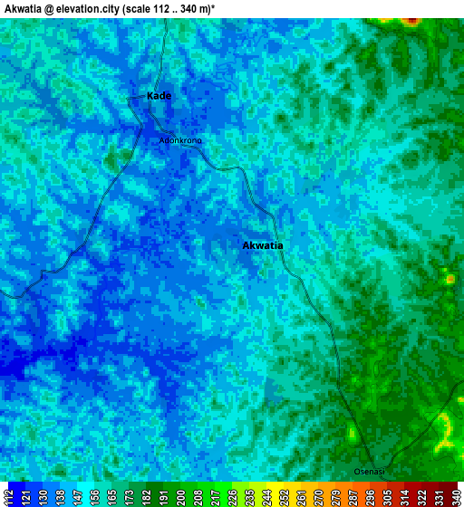
Below is the Elevation map of Akwatia, which displays elevation range with different colors. Scale of the first map is from 122 to 187 m (400 to 614 ft) with average elevation of 144.7 meters (=475 ft) [note 1]
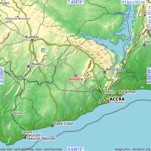
These maps also provides idea of topography and contour of this city, they are displayed at different zoom levels. More info about maps, scale and edge coordinates you can find below images.
| \ | Map #1 | Map #2 | Topo.Map |
| Scale [m] | 122..187 m | 112..340 m | × |
| Scale [ft] | 400..614 ft | 367..1115 ft | × |
| Average | 144.7 m = 475 ft | 154.1 m = 506 ft | × |
| Width | 9.72 km = 6 mi | 19.44 km = 12.1 mi | 311 km = 193.2 mi |
| Height | 9.72 km = 6 mi | 19.44 km = 12.1 mi | 311 km = 193.2 mi |
| ↑Max Latitude | 6.08394° | 6.127636° | 7.43674° |
| Latitude at center | 6.04024° | 6.04024° | 6.04024° |
| ↓Min Latitude | 5.996537° | 5.95283° | 4.64013° |
| ← Min Longitude | -0.852705° | -0.896651° | -2.21501° |
| Longitude center | -0.80876° | -0.80876° | -0.80876° |
| →Max Longitude | -0.764815° | -0.720869° | 0.59749° |
Nearby cities:
Cities around Akwatia sort by population:
• Koforidua elevation 172 m
61.1 km,  84°
84°
• Akim Oda 132 m
23.3 km,  237°
237°
• Swedru 74 m
57.2 km,  167°
167°
• Suhum 182 m
39.7 km,  89°
89°
• Nsawam 61 m
56.9 km,  116°
116°
• Asamankese 147 m
25.7 km,  141°
141°
• Begoro 460 m
61.3 km,  51°
51°
• Foso 148 m
64.9 km,  234°
234°
• Akim Swedru 140 m
28.1 km, 234°
• Kibi 318 m
31.4 km,  63°
63°
• Mpraeso 477 m
62 km,  7°
7°
• Odumase Krobo 214 m
54.8 km,  359°
359°
Multilingual:
 En español:
Akwatia elevación 138 m.
 En France:
Akwatia élévation 138 m.


Sources and notes:
- [note 1] Map square and city borders are not equal. Map elevation data is calculated only from area inside that square.
- [src 1] Elevation data from geonames database provided with same terms of usage.
- [src 2] The elevation map of Akwatia is generated using elevation data from NASA's 3 arcsec (90m) resolution SRTM data.
- [src 3] Base (background) map © OpenStreetMap contributors tiles are generated by Geofabrik and OpenTopoMap.
Copyright & License:
This Akwatia Elevation Map is licensed under CC BY-SA. You may reuse any part from this page, if you give a proper credit by linking to this URL:
 More info on terms of use page.